Boigneville

Last updated • 1 min readFrom Wikipedia, The Free Encyclopedia
Boigneville
Boigneville IMG 5127.jpg
The town hall of Boigneville
Location of Boigneville
Boigneville
France location map-Regions and departements-2016.svg
Red pog.svg
Boigneville
Ile-de-France region location map.svg
Red pog.svg
Boigneville
Coordinates: 48°20′06″N2°22′15″E / 48.3351°N 2.3707°E / 48.3351; 2.3707
Country France
Region Île-de-France
Department Essonne
Arrondissement Évry
Canton Mennecy
Government
  Mayor (20202026) Jean-Jacques Boussaingault [1]
Area
1
15.80 km2 (6.10 sq mi)
Population
 (2021) [2]
383
  Density24/km2 (63/sq mi)
Time zone UTC+01:00 (CET)
  Summer (DST) UTC+02:00 (CEST)
INSEE/Postal code
91069 /91720
Elevation67–143 m (220–469 ft)
1 French Land Register data, which excludes lakes, ponds, glaciers > 1 km2 (0.386 sq mi or 247 acres) and river estuaries.

Boigneville (French pronunciation: [bwaɲvil] ) is a commune in the Essonne department in Île-de-France in northern France.

Contents

Inhabitants of Boigneville are known as Boignevillois.

Geography

Climate

Boigneville has an oceanic climate (Köppen climate classification Cfb). The average annual temperature in Boigneville is 11.5 °C (52.7 °F). The average annual rainfall is 615.6 mm (24.24 in) with May as the wettest month. The temperatures are highest on average in July, at around 19.9 °C (67.8 °F), and lowest in January, at around 4.3 °C (39.7 °F). The highest temperature ever recorded in Boigneville was 40.9 °C (105.6 °F) on 25 July 2019; the coldest temperature ever recorded was −18.1 °C (−0.6 °F) on 16 January 1985.

Climate data for Boigneville (1991−2020 normals, extremes 1979−present)
MonthJanFebMarAprMayJunJulAugSepOctNovDecYear
Record high °C (°F)15.5
(59.9)
21.4
(70.5)
25.5
(77.9)
28.4
(83.1)
31.6
(88.9)
37.2
(99.0)
40.9
(105.6)
39.7
(103.5)
34.7
(94.5)
30.3
(86.5)
21.8
(71.2)
17.2
(63.0)
40.9
(105.6)
Mean daily maximum °C (°F)6.9
(44.4)
8.2
(46.8)
12.3
(54.1)
15.9
(60.6)
19.4
(66.9)
22.9
(73.2)
26.0
(78.8)
25.8
(78.4)
21.4
(70.5)
16.1
(61.0)
10.5
(50.9)
7.2
(45.0)
16.1
(61.0)
Daily mean °C (°F)4.3
(39.7)
4.8
(40.6)
7.8
(46.0)
10.6
(51.1)
14.0
(57.2)
17.3
(63.1)
19.9
(67.8)
19.6
(67.3)
15.9
(60.6)
12.0
(53.6)
7.4
(45.3)
4.6
(40.3)
11.5
(52.7)
Mean daily minimum °C (°F)1.7
(35.1)
1.4
(34.5)
3.3
(37.9)
5.3
(41.5)
8.7
(47.7)
11.7
(53.1)
13.6
(56.5)
13.4
(56.1)
10.4
(50.7)
7.9
(46.2)
4.4
(39.9)
2.1
(35.8)
7.0
(44.6)
Record low °C (°F)−18.1
(−0.6)
−12.6
(9.3)
−11.6
(11.1)
−4.3
(24.3)
−0.1
(31.8)
1.4
(34.5)
4.0
(39.2)
4.6
(40.3)
2.0
(35.6)
−3.3
(26.1)
−10.7
(12.7)
−11.5
(11.3)
−18.1
(−0.6)
Average precipitation mm (inches)47.6
(1.87)
44.0
(1.73)
43.0
(1.69)
46.9
(1.85)
62.5
(2.46)
50.0
(1.97)
51.0
(2.01)
49.7
(1.96)
49.8
(1.96)
58.1
(2.29)
54.0
(2.13)
59.0
(2.32)
615.6
(24.24)
Average precipitation days (≥ 1.0 mm)11.39.58.99.09.48.37.67.37.69.810.611.8111.2
Source: Météo-France [3]

See also

Related Research Articles

<span class="mw-page-title-main">Athis-Mons</span> Commune in Île-de-France, France

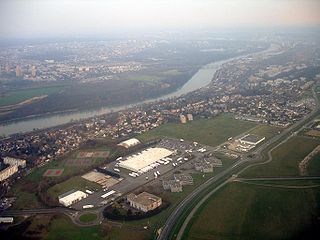
Athis-Mons is a commune in the southern suburbs of Paris, France. It is located 16.5 km (10.3 mi) from the center of Paris.

<span class="mw-page-title-main">Épinay-sur-Orge</span> Commune in Île-de-France, France

Épinay-sur-Orge is a commune in the Essonne department in Île-de-France in northern France.

<span class="mw-page-title-main">Montmélian</span> Commune in Auvergne-Rhône-Alpes, France

Montmélian is a commune in the Savoie department in the Auvergne-Rhône-Alpes region in south-eastern France. Montmélian station has rail connections to Grenoble, Modane, Bourg-Saint-Maurice and Chambéry.

Vestric-et-Candiac is a commune in the Gard department in southern France.

<span class="mw-page-title-main">Gometz-le-Châtel</span> Commune in Île-de-France, France

Gometz-le-Châtel is a commune in the Essonne department of France. It is a southern suburb of Paris, 25 km from the center of Paris.

<span class="mw-page-title-main">Lanleff</span> Commune in Brittany, France

Lanleff is a commune in the Côtes-d'Armor department of Brittany in northwestern France.

<span class="mw-page-title-main">Quetigny</span> Commune in Bourgogne-Franche-Comté, France

Quetigny is a commune in the Côte-d'Or department in eastern France.

<span class="mw-page-title-main">Champlan</span> Commune in Île-de-France, France

Champlan is a commune located 16 kilometres (10 mi) to the southwest of Paris, in the Essonne department in Île-de-France in northern France.

<span class="mw-page-title-main">Congerville-Thionville</span> Commune in Île-de-France, France

Congerville-Thionville is a commune in the Essonne department in Île-de-France in northern France.

<span class="mw-page-title-main">Courdimanche-sur-Essonne</span> Commune in Île-de-France, France

Courdimanche-sur-Essonne is a commune in the Essonne department in Île-de-France in northern France.

<span class="mw-page-title-main">Prades-le-Lez</span> Commune in Occitania, France

Prades-le-Lez is a commune in the Hérault department in the Occitanie region in southern France.

<span class="mw-page-title-main">Fontenay-lès-Briis</span> Commune in Île-de-France, France

Fontenay-lès-Briis is a commune in the Essonne department in Île-de-France in northern France.

<span class="mw-page-title-main">Nainville-les-Roches</span> Commune in Île-de-France, France

Nainville-les-Roches is a commune in the Essonne department in Île-de-France in northern France.

<span class="mw-page-title-main">Giromagny</span> Commune in Bourgogne-Franche-Comté, France

Giromagny is a commune in the Territoire de Belfort department in Bourgogne-Franche-Comté in northeastern France.

<span class="mw-page-title-main">Saint-Colomban-des-Villards</span> Commune in Auvergne-Rhône-Alpes, France

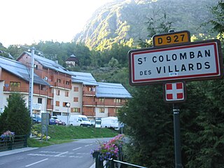
Saint-Colomban-des-Villards is a commune in the Savoie department in the Auvergne-Rhône-Alpes region in south-eastern France.

<span class="mw-page-title-main">Palluau</span> Commune in Pays de la Loire, France

Palluau is a commune in the Vendée department in the Pays de la Loire region in western France.

<span class="mw-page-title-main">Le Perrier</span> Commune in Pays de la Loire, France

Le Perrier is a commune in the Vendée department in the Pays de la Loire region in western France.

<span class="mw-page-title-main">Val Buëch-Méouge</span> Commune in Provence-Alpes-Côte dAzur, France

Val Buëch-Méouge is a commune in the Hautes-Alpes department of southeastern France. The municipality was established on 1 January 2016 and consists of the former communes of Ribiers, Châteauneuf-de-Chabre and Antonaves.

<span class="mw-page-title-main">Les Belleville</span> Commune in Auvergne-Rhône-Alpes, France

Les Belleville is a commune in the Savoie department of southeastern France. The municipality was established on 1 January 2016 by the merger of the former communes of Saint-Martin-de-Belleville and Villarlurin. On 1 January 2019, the former commune Saint-Jean-de-Belleville was merged into Les Belleville.

<span class="mw-page-title-main">Le Mérévillois</span> Commune in Île-de-France, France

Le Mérévillois is a commune in the department of Essonne.

References

  1. "Répertoire national des élus: les maires" (in French). data.gouv.fr, Plateforme ouverte des données publiques françaises. 13 September 2022.
  2. "Populations légales 2021" (in French). The National Institute of Statistics and Economic Studies. 28 December 2023.
  3. "Fiche Climatologique Statistiques 1991-2020 et records" (PDF) (in French). Météo-France . Retrieved August 30, 2022.