Bonifacio Avenue LRT station

Last updated
 Bonifacio Avenue 
Manila Light Rail Transit System
Location Ortigas Avenue Extension, Santo Domingo, Cainta, Rizal
Owned by Light Rail Transit Authority
Line(s) LRT-4
PlatformsIsland platform
Tracks2
Construction
Structure typeElevated
Disabled accessYes

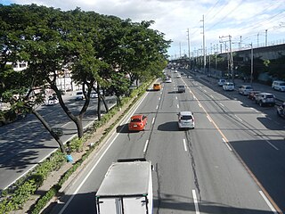
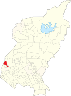
Bonifacio Avenue LRT station, also Cainta LRT station, is a proposed station along the planned Manila Light Rail Transit System Line 4 (LRT-4) in Cainta, Rizal, Philippines. It will be located at the intersection of Ortigas Avenue Extension with Bonifacio Avenue and Felix Avenue in the Cainta barangay of Santo Domingo adjacent to Robinsons Place Cainta shopping mall. Under the current proposal, the station will be the first LRT-4 station outside Metro Manila and the fourth station heading east along Ortigas Avenue towards Taytay from the LRT-4 terminus at EDSA. [1]

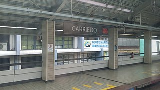
The Manila Light Rail Transit System Line 4 is a proposed rapid transit line to be built in Metro Manila and Rizal in the Philippines. When completed, it will be the second rapid transit line serving the province of Rizal after the extension of Line 2 to Antipolo.

Rizal Province in Calabarzon, Philippines

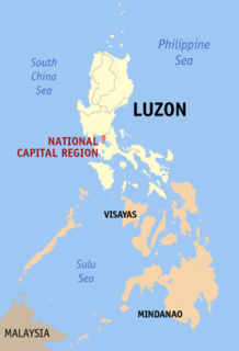
Rizal, officially known as the Province of Rizal, is a province in the Philippines located in the Calabarzon region, 16 kilometres (9.9 mi) east of Manila. The province is named after José Rizal, one of the main national heroes of the Philippines. Rizal is bordered by Metro Manila to the west, Bulacan to the north, Quezon to the east and Laguna to the southeast. The province also lies on the northern shores of Laguna de Bay, the largest lake in the country. Rizal is a mountainous province perched on the western slopes of the southern portion of the Sierra Madre mountain range.

Philippines Republic in Southeast Asia

The Philippines, officially the Republic of the Philippines, is an archipelagic country in Southeast Asia. Situated in the western Pacific Ocean, it consists of about 7,641 islands that are categorized broadly under three main geographical divisions from north to south: Luzon, Visayas, and Mindanao. The capital city of the Philippines is Manila and the most populous city is Quezon City, both part of Metro Manila. Bounded by the South China Sea on the west, the Philippine Sea on the east and the Celebes Sea on the southwest, the Philippines shares maritime borders with Taiwan to the north, Vietnam to the west, Palau to the east, and Malaysia and Indonesia to the south.

When built, the station will serve the poblacion (municipal proper) of Cainta and the following destinations: Cainta Municipal Hall, Our Lady of Light Parish Church, Cainta Public Market and Rockbuilt manufacturing complex. It will also be located near a terminal for buses and jeepneys bound for Taytay, Antipolo, Angono and other municipalities along the Manila East Road.

Poblacion or población is the common term used for the central, downtown, old town or central business district area of a Philippine city or municipality, which may take up the area of a single barangay or multiple barangays. It is sometimes shortened to Pob.

Our Lady of Light Parish Church Church in Rizal, Philippines

Diocesan Shrine and Parish of Our Lady of Light, popularly known as Cainta Church, is a Roman Catholic parish church located along Andres Bonifacio Avenue in Barangay San Andres, Cainta, Rizal in the Philippines. The church also operates a neighboring school, Cainta Catholic College. From its time of erection as a parish in 1760 until 1983, it belonged to the Archdiocese of Manila. It was placed under the newly created Diocese of Antipolo in 1983, which is now headed by Most Rev. Francisco M. De Leon. It belongs to the Vicariate of Our Lady of Light.

Antipolo Component City in Calabarzon, Philippines

Antipolo, officially the City of Antipolo,, or simply known as Antipolo City, is a 1st class city and the capital of the province of Rizal, Philippines. According to the 2015 census, it has a population of 776,386 people.

Related Research Articles

Cainta Municipality in Calabarzon, Philippines

Cainta, officially the Municipality of Cainta,, is a 1st class municipality in the province of Rizal, Philippines. According to the 2015 census, it has a population of 322,128 people.

Monumento LRT station station on the Manila LRT Yellow Line (LRT-1)

Monumento LRT station is a station on the Manila LRT (LRT-1). Like all other LRT-1 stations, Monumento is above-ground. The station serves the southern portion of Caloocan, and is named after the most famous landmark of Caloocan, the Monumento Circle, which houses the Bonifacio Monument, a famous monument to Andrés Bonifacio. The name Monumento itself is derived from the Spanish word for monument. Being a former terminal in LRT-1, it is called Monumento Terminal.

Central Terminal LRT station station on the Manila LRT Yellow Line (LRT-1)

Central Terminal station, sometimes called Central or Arroceros LRT station, is a Manila Light Rail Transit System in Manila, Philippines. It serves Line 1 (LRT-1). Like all other LRT-1 stations, Central Terminal is above-ground. It is located in Ermita in Manila. A popular name for the station is Arroceros, having been given its name because the station lies in Arroceros Street. The site where the train station now stands was a former site of an ice processing plant that was prominent during the American occupation.

Carriedo LRT station station on the Manila LRT Yellow Line (LRT-1)

Carriedo LRT station is a station on the Manila LRT (LRT-1). Like all other LRT-1 stations, Carriedo station is above-ground. The station is located in Santa Cruz in Manila. The station is named after Carriedo Street, which is near the station. It is the only station in the entire LRT system with a canopy roof.

Manila Light Rail Transit System Line 1 The first rapid transit line of Metro Manila.

The Manila Light Rail Transit System Line 1 is the first metro line of the Manila Light Rail Transit System. Presently, the line contains twenty stations and runs on 19.65 kilometers (12.21 mi) of fully elevated route. The line is colored yellow (old) and green (new) on all railway maps.

Balintawak LRT station station on the Manila LRT Yellow Line (LRT-1)

Balintawak LRT station is a station on the Manila LRT Line 1, and has been constructed during the Line 1 North Extension Project. It opened on March 22, 2010. This station, along with the proposed Malvar station will serve passengers going to and from the northern parts of Luzon using the North Luzon Expressway.

Marikina–Infanta Highway road in the Philippines

The Marikina–Infanta Highway, also known as the Marcos Highway or MARILAQUE Highway, is a scenic mountain 110-kilometer highway that connects Metro Manila with Infanta, Quezon in the Philippines.

The public transportation system in Metro Manila, Philippines is woefully inadequate to accommodate the mobility and other basic needs of an overpopulated metropolis, the result of many factors and problems that the government has failed to provide or address. Metro Manila exists in a state of near-permanent gridlock, with people and goods trapped by the very transportation system that is supposed to move them quickly and efficiently. Because of the insufficient public transportation network, car ownership has risen dramatically, contributing further to the congestion that occurs at all times of day on the road. Filipinos view cars as tools to get them to where they need to go; they also believe that their car is an important symbol of the success they have achieved in life. In recent years, however, the Philippine government has been pushing to improve the system through various infrastructure projects, hoping to solve the interlinked problems of transportation, land use and environment.

Emerald station is an under construction station on the Manila Light Rail Transit System Line 2 in the Philippines. It is part of the Line 2 East Extension. This station would be the first Line 2 station to be located outside of Metro Manila.

Masinag station is an under construction station of the Manila Light Rail Transit System Line 2 located in the city of Antipolo, on the Philippine province of Rizal.

The Manila Light Rail Transit System Line 6or Line 6 of the Manila Light Rail Transit System Line 1, was a proposed rapid transit line planned to link the suburban city of Dasmariñas to the future Manila Line 1 extension at Niog station in Bacoor. Its path would have run along a north-south axis over a length of 19 kilometres (12 mi). Its proposed right-of-way alignment is along Aguinaldo Highway from Niog in Bacoor to Governor's Drive in Dasmariñas.

The Congressional Avenue LRT station is a proposed stop on the Manila Light Rail Transit System Line 6 (LRT-6) in the Philippines. The station will be located at the boundaries of Pasong Lawin and Barangay Zone IV in Dasmariñas, Cavite at the intersection of Aguinaldo Highway with Gov. Dominador Mangubat Avenue and Isidro Mangubat Street. Like most stations of the planned Manila LRT-1 south extension from Baclaran to Niog, the station will be above ground. It will be the fifth stop on the LRT-6 from Niog station and the first for trains heading north from the proposed southern terminus at Governor's Drive.

Meralco LRT station is a proposed station along the planned Manila Light Rail Transit System Line 4 in Pasig, Metro Manila, Philippines. It will be located near the intersection of Ortigas Avenue and Meralco Avenue in Ugong and will be adjacent to the Manila Electric Company (Meralco) Center building. Under the current proposal, the station will be the second heading east from its interchange with Ortigas MRT station on EDSA towards suburban Taytay along busy Ortigas Avenue.

Julia Vargas LRT station is a proposed station along the planned Manila Light Rail Transit System Line 4 (LRT-4) in Quezon City, Metro Manila, Philippines. It will be located at the intersection of Doña Julia Vargas Avenue and ADB Avenue in Ugong Norte adjacent to the Podium.

Pasig LRT station is a proposed station along the planned Manila Light Rail Transit System Line 4 in Pasig, Metro Manila, Philippines. It will be located at the intersection of Ortigas Avenue and Dr. Sixto Antonio Avenue in the Pasig barangay of Rosario, at the foot of the Marikina River crossing of Rosario Bridge from Eulogio Rodriguez Jr. Avenue (C-5).

L. Wood LRT station is a proposed station along the planned Manila Light Rail Transit System Line 4 in Taytay, Rizal, Philippines. It will be located at the Tikling Junction which is the intersection of Ortigas Avenue Extension with Leonard Wood Road and Taytay Diversion Road in the Taytay poblacion of Dolores.

Taytay LRT station is one of two proposed stations along the planned Manila Light Rail Transit System Line 4 in Taytay, Rizal, Philippines. It will be located in Dolores, the poblacion of Taytay, by the SM City Taytay shopping mall on Taytay Diversion Road. It will be the eastern terminus station of LRT-4.

Index of Metro Manila-related articles

The following is an alphabetical list of articles related to the Philippine capital region of Metro Manila.

Balingasa Barangay in National Capital Region, Philippines

Balingasa, more commonly known as Balintawak and Cloverleaf, is one of many barangays located in the west portion of Quezon City sharing a boundary with Caloocan City.

References

  1. "LRT Line 6 Project Construction, Operation and Maintenance". Public-Private Partnership Center. Retrieved 9 July 2015.