San Andres railway station

Last updated

 San Andres 
Philippine National Railways
PNR San Andres.jpg
Trackbed and platform area of San Andres station
Location South Luzon Expressway cor. San Andres St.
San Andres, Manila
Coordinates 14°34′22.60″N120°59′58.65″E / 14.5729444°N 120.9996250°E / 14.5729444; 120.9996250 Coordinates: 14°34′22.60″N120°59′58.65″E / 14.5729444°N 120.9996250°E / 14.5729444; 120.9996250
Owned by Philippine National Railways
Line(s) PNR Southrail
PlatformsSide platforms
Tracks2
Construction
Structure typeAt grade
Disabled accessYes
Other information
Station codeSAN
History
OpenedMarch 24, 2010
Services
Preceding station  PNR  Following station
toward  Tutuban
Metro South Commuter
toward  Calamba
PNR Metro Commuter
North-South Commuter Line
BSicon exKBHFa orange.svg
Valenzuela
BSicon dWASSERq.svgBSicon hKRZWae orange.svgBSicon dWASSERq.svg
BSicon GRZq.svg
BSicon exSTR orange.svg
BSicon ACC orange.svg
BSicon exSTR orange.svg
Governor Pascual
BSicon GRZq.svg
BSicon STR orange.svg
BSicon HSTACC orange.svg
Caloocan
BSicon ABZg+l orange.svgBSicon KDSTeq orange.svg
Caloocan Depot
BSicon HSTACC orange.svg
10th Avenue
BSicon HSTACC orange.svg
5th Avenue
BSicon GRZq.svg
BSicon STR orange.svg
BSicon HSTACC orange.svg
Solis
BSicon uexhCONTg.svgBSicon STR orange.svg
 
Arrow Blue Up 001.svgPier 4
BSicon uexhSTR.svgBSicon KDSTa orange.svgBSicon STR orange.svg
Tutuban Railyard (Tayuman Locomotive Shed)
BSicon HUBaq.svg
BSicon uexhINTACC.svg
BSicon HUBeq.svg
BSicon KINTACCaq orange.svg
BSicon STRl orange.svg
BSicon STRr orange.svg
BSicon STRq orange.svg
BSicon STR+r orange.svg
BSicon ABZgr orange.svg
BSicon exSUBWAY.svg
Tutuban
  2  
BSicon uhSTR.svgBSicon fhCONTgq.svg
BSicon INTACC orange.svg
BSicon fhINTACCq.svg
BSicon fhCONTfq.svgBSicon TRAM.svg
Blumentritt
  1  
BSicon uhSTR.svgBSicon STR orange.svg
Arrow Blue Left 001.svgBaclaran - Niog
Roosevelt - North AvenueArrow Blue Right 001.svg
BSicon uhSTR.svgBSicon HSTACC orange.svg
Laong Laan
BSicon uhSTR.svgBSicon INTACC orange.svgBSicon exhCONTgq.svgBSicon exhINTACCq.svgBSicon exhCONTfq.svgBSicon exSUBWAY.svg
España
  8  
BSicon uhSTR.svgBSicon STR orange.svg
Arrow Blue Left 001.svgLerma - University AvenueArrow Blue Right 001.svg
 
BSicon uhSTRl.svgBSicon uhINTACCq.svgBSicon uhCONTfq.svgBSicon INTACC orange.svgBSicon SUBWAY.svg
Santa Mesa
  2  
BSicon STR orange.svg
Santolan - MasinagArrow Blue Right 001.svg
 
BSicon dWASSERq.svgBSicon hKRZWae orange.svgBSicon dWASSERq.svg
Estero de Pandacan
BSicon HSTACC orange.svg
Pandacan
BSicon dWASSERq.svgBSicon hKRZWae orange.svgBSicon dWASSERq.svg
Estero de Pandacan
BSicon HSTACC orange.svg
Paco
BSicon HSTACC orange.svg
San Andres
BSicon HSTACC orange.svg
Vito Cruz
BSicon GRZq.svg
BSicon STR orange.svg
BSicon eHSTACC orange.svg
Buendia
BSicon HSTACC orange.svg
Dela Rosa
BSicon HSTACC orange.svg
Pasay Road
BSicon dWASSERq.svgBSicon hKRZWae orange.svgBSicon dWASSERq.svg
Estero de Tripa de Gallina
BSicon INTACC orange.svgBSicon hCONTgq yellow.svgBSicon hINTACCq yellow.svgBSicon hCONTfq yellow.svgBSicon TRAM.svg
EDSA
  3  
BSicon STR orange.svg
Arrow Blue Left 001.svgNorth Avenue - Taft AvenueArrow Blue Right 001.svg
 
BSicon GRZq.svg
BSicon STR orange.svg
Makati
 
BSicon dWASSERq.svgBSicon hKRZWae orange.svgBSicon dWASSERq.svg
Estero de Tripa de Gallina
BSicon GRZq.svg
BSicon STR orange.svg
BSicon extSTR+l.svgBSicon extCONTfq.svg
 
Taguig
BSicon HUBaq.svg
BSicon INTACC orange.svg
BSicon HUBeq.svg
BSicon extINTACC.svg
BSicon FLUG.svgBSicon exSUBWAY.svg
Nichols
BSicon FLUG.svg   9  
BSicon extCONTgq.svg
BSicon extSTRq.svg
BSicon extSTR+l.svg
BSicon STR orange.svg
BSicon extSTRq.svg
BSicon extSTRr.svg
Arrow Blue Left 001.svgNAIA Terminal 3 - Quirino HighwayArrow Blue Right 001.svg
 
BSicon HUBaq.svg
BSicon extKINTACCe.svg
BSicon HUBeq.svg
BSicon INTACC orange.svg
BSicon exBUS2.svgBSicon exSUBWAY.svg
FTI
  9  
BSicon GRZq.svg
BSicon STR orange.svg
BSicon HSTACC orange.svg
Bicutan
BSicon GRZq.svg
BSicon STR orange.svg
BSicon HSTACC orange.svg
Sucat
BSicon dWASSERq.svgBSicon hKRZWae orange.svgBSicon dWASSERq.svg
Sucat River
BSicon dWASSERq.svgBSicon hKRZWae orange.svgBSicon dWASSERq.svg
BSicon ACC orange.svgBSicon BUS2.svg
Alabang
BSicon dWASSERq.svgBSicon hKRZWae orange.svgBSicon dWASSERq.svg
Bayanan Creek
BSicon dWASSERq.svgBSicon hKRZWae orange.svgBSicon dWASSERq.svg
Poblacion River
BSicon HSTACC orange.svg
Muntinlupa
BSicon dWASSERq.svgBSicon hKRZWae orange.svgBSicon dWASSERq.svg
Magdaong River
BSicon eHST orange.svg
Tunasan
BSicon GRZq.svg
BSicon STR orange.svg
BSicon dWASSERq.svgBSicon hKRZWae orange.svgBSicon dWASSERq.svg
Tunasan River
BSicon GRZq.svg
BSicon STR orange.svg
BSicon dWASSERq.svgBSicon hKRZWae orange.svgBSicon dWASSERq.svg
San Isidro River
BSicon HSTACC orange.svg
San Pedro
BSicon exSTR+l orange.svg
BSicon STR orange.svg
BSicon exSTRr orange.svg
BSicon GRZq.svg
BSicon exSTR orange.svg
BSicon STR orange.svg
BSicon exKBHFe orange.svgBSicon STR orange.svg
Carmona
BSicon HST orange.svg
Pacita MG
BSicon GRZq.svg
BSicon STR orange.svg
BSicon HST orange.svg
Golden City 1
BSicon HSTACC orange.svg
Biñan
BSicon dWASSERq.svgBSicon hKRZWae orange.svgBSicon dWASSERq.svg
Biñan River
BSicon GRZq.svg
BSicon STR orange.svg
BSicon dWASSERq.svgBSicon hKRZWae orange.svgBSicon dWASSERq.svg
Silang-Sta. Rosa River
BSicon HSTACC orange.svg
Santa Rosa
BSicon eHST orange.svg
Golden City 2
BSicon GRZq.svg
BSicon STR orange.svg
BSicon dWASSERq.svgBSicon hKRZWae orange.svgBSicon dWASSERq.svg
Cabuyao River System
BSicon HSTACC orange.svg
Cabuyao
BSicon eHST orange.svg
Gulod
BSicon dWASSERq.svgBSicon hKRZWae orange.svgBSicon dWASSERq.svg
Cabuyao River System
BSicon ACC orange.svg
Mamatid
BSicon eHST orange.svg
Banlic
BSicon GRZq.svg
BSicon STR orange.svg
BSicon dWASSERq.svgBSicon hKRZWae orange.svgBSicon dWASSERq.svg
BSicon KACCe orange.svg
Calamba

San Andres station is a station of the South Main Line ("Southrail") of the Philippine National Railways. Like all PNR stations, this station is at grade. It is located at the intersection of Aviadores Street, San Andres Street and the South Luzon Expressway in San Andres, Manila.

Philippine National Railways Railway company in the Philippines

The Philippine National Railways (PNR) is a state-owned railway company in the Philippines, operating a single line of track on Luzon. As of 2016, it operates one commuter rail service in Metro Manila and local services between Sipocot, Naga City and Legazpi City in the Bicol Region. PNR began operations on November 24, 1892 as the Ferrocarril de Manila-Dagupan, during the Spanish colonial period, and later becoming the Manila Railroad Company (MRR) during the American colonial period. It became the Philippine National Railways on June 20, 1964 by virtue of Republic Act No. 4156. The PNR is an agency of the Department of Transportation.

South Luzon Expressway major controlled-access highway in the Philippines

The South Luzon Expressway, formerly known as the South Superhighway (SSH), Manila South Diversion Road (MSDR), and Manila South Expressway (MSEX), is a network of two expressways that connects Metro Manila to the provinces of the Calabarzon region in the Philippines. The first expressway is the Skyway, operated jointly by the Skyway Operation and Management Corporation (SomCo) and Citra Metro Manila Tollways Corporation (CMMTC). The second expressway, the South Luzon Tollway or Alabang–Calamba–Santo Tomas Expressway (ACTEx), is jointly operated by the South Luzon Tollway Corporation, a joint venture of the Philippine National Construction Corporation and the San Miguel Corporation-backed Citra group of Indonesia via the Manila Toll Expressway Systems, Inc. (MATES).

San Andres, Manila Place in National Capital Region, Philippines

San Andres is a district of Manila, Philippines. San Andres shares the Estero Tripa de Gallina as its western and northern border with the districts of Malate and Paco, respectively and Pedro Gil and Tejeron streets to the east with the district of Santa Ana. It borders the cities of Pasay and Makati in the south. The area is under the jurisdiction of the Fifth Congressional District of Manila, and includes the Manila South Cemetery, an exclave of the city.

Contents

San Andres station is the seventh station southbound from Tutuban.

Tutuban railway station a station of the Philippine National Railways (PNR)

Tutuban station commonly as Manila railway Station or Divisoria railway Station is the main train station of the Philippine National Railways (PNR) and the main train station of the city of Manila in the Philippines. It was formerly known as the Manila Railroad Company (MRRCo). The name refers to two stations: the original Tutuban station, which today forms part of the Tutuban Centermall, and the PNR Executive Building, which houses PNR offices and serves as the current terminus of all PNR services.

History

The original San Andres station was opened around 1929 as a flagstop on the defunct Naic Line and closed in 1936.

A new San Andres station on the Main Line South was opened on March 24, 2010 for commuter services.

Nearby landmarks

The station is near the Singalong sub-district of San Andres, the Dagonoy Public Market and the St. Anthony's School, Manila. Further away from the station are the Br. Andrew Gonzalez Hall of De La Salle University, the Bureau of Plant Industry, Ermita, Puregold(Osmeña Highway) and the Manila Zoological and Botanical Garden.

Br. Andrew Gonzalez Hall

The Br. Andrew Gonzalez Hall is a 20 storey academic complex designed by Philip H. Recto Architects for De La Salle University. It is located on a 1,700-square-meter lot between Taft Avenue and Fidel Reyes St. and in front of the Enrique M. Razon Sports Center. Rising to a height of 90 meters, it is said to be the highest educational structure in the Philippines. The building houses the General Education Department, the College of Education and the Asia-Pacific Center for Teachers’ Education and Development (ACTED). The building was formerly referred to as the GE/CED/ACTED Building before being named in honor of Br. Andrew Gonzalez FSC on September 28, 2005. The building was formally inaugurated on March 1, 2007 in celebration of Br. Andrew's 67th birthday. The building was opened for use in May 2006 for the first trimester despite not being completely finished at the time.

De La Salle University Roman Catholic, Lasallian research university in Taft Avenue, Malate, Manila, Philippines

De La Salle University, also known as La Salle and abbreviated DLSU, is a leading private, Catholic research university run by De La Salle Brothers located in Taft Avenue, Malate, Manila, Philippines. It was established in 1911 as the De La Salle College in Nozaleda Street, Paco, Manila with Br. Blimond Pierre serving as first director. The educational institution moved to its present location on September 21 to facilitate the increase in enrollment. The college was granted university status in February 1975 and is the oldest constituent of De La Salle Philippines (DLSP), a network of 17 Lasallian institutions established in 2006 to replace the De La Salle University System.

Bureau of Plant Industry (Philippines)

The Philippines' Bureau of Plant Industry, is an agency of the Philippine government under the Department of Agriculture responsible for serving and supporting the Philippine plant industry sector.

San Andres station is accessible by jeepneys plying the San Andres route, as well as buses plying routes on the South Luzon Expressway. A LRT-1 station, Quirino Avenue, is located further up San Andres Street on the intersection with Taft Avenue.

Manila Light Rail Transit System Line 1 The first rapid transit line of Metro Manila.

The Manila Light Rail Transit System Line 1 is the first metro line of the Manila Light Rail Transit System. Presently, the line contains twenty stations and runs on 19.65 kilometers (12.21 mi) of fully elevated route. The line is colored yellow (old) and green (new) on all railway maps.

Taft Avenue major street in Metro Manila, Philippines

Taft Avenue is a major road in the south of Metro Manila. It passes through three cities in the metropolis: Manila, Pasay and Parañaque. The road was named after the former Governor-General of the Philippines and U.S President, William Howard Taft. The Philippines was a former commonwealth territory of the United States in the first half of the twentieth century. It is a component of National Route 170 (N170), a secondary road in the Philippine highway network and anchors R-2 of the Manila arterial road network.

Station Layout

L1
Platforms
Side platform, doors will open on the right
Platform A PNR Metro Commuter towards Tutuban (←)
Platform B PNR Metro Commuter towards Alabang (→)
Side platform, doors will open on the right
L1Concourse/
Street Level
Ticket Booths, Station Control, Shops,Dagonoy Public Market, St. Anthony's School-Manila,

Related Research Articles

EDSA (road) road in the Philippines

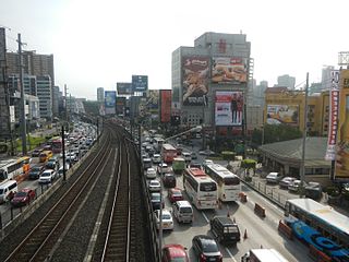
Epifanio de los Santos Avenue, commonly referred to by its acronym EDSA, is a limited-access circumferential highway around Manila, the capital of the Philippines. It is the main thoroughfare in Metro Manila passing through 6 of the capital region's 17 local government units, namely, from north to south, Caloocan, Quezon City, San Juan, Mandaluyong, Makati and Pasay.

North Luzon Expressway major controlled-access highway in the Philippines

The North Luzon Expressway, formerly known as the North Diversion Road and Manila North Expressway (MNEX), is a 4 to 8-lane limited-access toll expressway that connects Metro Manila to the provinces of the Central Luzon region in the Philippines. It is a component of Expressway 1 (E1) of the Philippine expressway network, Circumferential Road 5 (C-5) and Radial Road 8 (R-8) of Manila's arterial road network. It was built in the 1960s.

Balintawak station station on the Manila LRT Yellow Line (LRT-1)

Balintawak station is a station on the Manila Light Rail Transit System Line 1, and has been constructed during the Line 1 North Extension Project. It opened on March 22, 2010. This station, along with the proposed Malvar station will serve passengers going to and from the northern parts of Luzon using the North Luzon Expressway.

Magallanes station station on the Manila Line 3 (MRT-3)

Magallanes Station is a station on the Manila Metro Rail Transit System Line 3. It is one of the many elevated stations found on the line. The station is named after the Magallanes district of Makati, which in turn is named after Ferdinand Magellan, who discovered the Philippines for Spain on April 15, 1521. Although the station is named after Magallanes, it also serves passengers from barangays Kayamanan-C, Dasmariñas, Pio del Pilar, and San Lorenzo in Makati, and those from Taguig.

Circumferential Road 5 road in the Philippines

Circumferential Road 5, more commonly known as C-5 Road or C-5, is a network of roads and bridges that altogether forms a major route that transverses in Metro Manila, in the National Capital Region of the Philippines. It is also known officially as Carlos P. Garcia Avenue, and as National Route 11 (N11), National Route 128 (N128) and National Route 129 (N129) in the National Route Numbering System implemented in 2014. Expressway portions, part of the North Luzon Expressway Mindanao Avenue and Karuhatan Link, are numbered Expressway 5 (E5).

Radial Road 3

Radial Road 3 (R-3) is a network of roads and bridges that altogether form the third arterial road of Manila in the Philippines. The road runs north-south linking the City of Manila to the southern Metro Manila cities of Makati, Pasay, Taguig, Parañaque and Muntinlupa, down to San Pedro, Biñan, Santa Rosa, Cabuyao and Calamba in the province of Laguna, all the way to the Southern Tagalog Arterial Road from Santo Tomas to Batangas City in the province of Batangas. The portion of R-3 from Epifanio de los Santos Avenue (EDSA) in Makati to Calamba also forms part of the Pan-Philippine Highway network (AH26).

Buendia railway station a station on the South Main Line ("Southrail") of the Philippine National Railways

Buendia was a station on the South Main Line ("Southrail") of the Philippine National Railways. Like all PNR stations, this station is at grade. The station was located at the corner of Gil Puyat Avenue and the South Luzon Expressway in Makati.

Nichols railway station

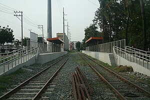
Nichols station is a station of the South Main Line ("Southrail") of the Philippine National Railways. Like all PNR stations, this station is at grade. It is located on the East Service Road of the South Luzon Expressway in Taguig, on the foot of the Sales Interchange, and takes its name from one of the area's popular nicknames, Nichols, which is also the former name of Villamor Airbase. It was opened for revenue service on March 25, 2010.

Vito Cruz railway station

Vito Cruz is a station on the South Main Line ("Southrail") of the Philippine National Railways. Like all PNR stations, this station is at grade. The station is located at the corner of Pablo Ocampo Street Extension and the South Luzon Expressway in San Andres, Manila, near the border with Makati City.

EDSA railway station

EDSA station is a station on the South Main Line ("Southrail") of the Philippine National Railways. Like all PNR stations, this station is at grade. The station is located at the intersection of the South Luzon Expressway and Epifanio de los Santos Avenue in Makati, below the Magallanes Interchange.

Bicutan railway station a station on the South Main Line ("Southrail") of the Philippine National Railways

Bicutan station is a station on the South Main Line ("Southrail") of the Philippine National Railways. Like all PNR stations, this station is at grade. The station is located on General Santos Avenue in Parañaque, near the border with Taguig and beside the ramp for northbound vehicles entering the South Luzon Expressway.

Pasay Road railway station

Pasay Road is a station on the South Main Line ("Southrail") of the Philippine National Railways. Like all PNR stations, this station is at grade. The station is located on Estacion Street in Barangay Pio del Pilar in Makati, making it only one of two stations to have its own access road. It is named after Pasay Road, the old name of the Makati section of Arnaiz Avenue.

Sucat railway station

Sucat station is a station on the South Main Line ("Southrail") of the Philippine National Railways. Like all PNR stations, this station is at grade. The station is located on Meralco Road in Muntinlupa, near the South Luzon Expressway.

Alabang railway station a station on the South Main Line ("Southrail") of the Philippine National Railways

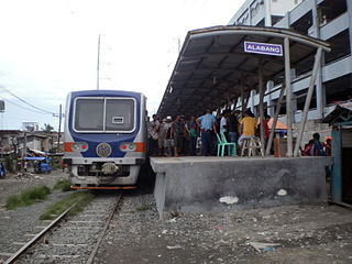
Alabang Station is a station on the South Main Line ("Southrail") of the Philippine National Railways. Like all PNR stations, this station is at grade. The station is located on T. Molina Street in Alabang, Muntinlupa, near the Alabang Viaduct of the South Luzon Expressway.

Circumferential Road 2

Circumferential Road 2 is a 2-12 lane network of roads and segments that altogether form the second circumferential road that acts as a beltway of the City of Manila. It is the Second Circumferential Road, labeled C-2 in the Manila Arterial Road System. It is a route running inside the city of Manila proper, passing through the Paco, Ermita and Malate districts.

Pablo Ocampo Street street in Metro Manila, Philippines

Pablo Ocampo Street is an inner city main road in Manila, Philippines. It runs west-east for about 3.4 kilometers connecting the southern districts of Malate and San Andres southeast to Makati.

Quirino Avenue major street in Manila, Philippines

President Elpidio Quirino Avenue, more commonly known as Quirino Avenue, is a 6-10 lane divided highway in Manila, Philippines. It runs for 3.6 kilometers in a northeast-southwest direction from Nagtahan Bridge across from Santa Mesa in the north to Roxas Boulevard in Malate in the south. It passes through Paco and Pandacan districts where it also serves as a truck route between Port Area and South Luzon Expressway. North of Nagtahan Bridge, the road continues as Lacson Avenue. It is designated as part of Circumferential Road 2.

Dr. Santos Avenue road in the Philippines

The Dr. Arcadio Santos Avenue or Dr. Santos Avenue,, is the primary east-west thoroughfare in Parañaque, southern Metro Manila, Philippines. The avenue's western end is at Victor Medina Street in the boundary between La Huerta and San Dionisio, as the continuation of Ninoy Aquino Avenue. Physically, Ninoy Aquino Avenue connects northbound to NAIA Road in Pasay which, in turn, continues west to Roxas Boulevard back in Parañaque, and then to Macapagal Boulevard, where it finally ends. Its eastern end is at South Luzon Expressway, at the city's border with Sucat, Muntinlupa, where it becomes Meralco Road to service the rest of the route to Sucat railway station.

Dela Rosa railway station

Dela Rosa is a station on the South Main Line ("Southrail") of the Philippine National Railways. Like all PNR stations, this station is at grade. The station is located at the corner of Dela Rosa Street and the South Luzon Expressway in Makati.