
Laguna, officially the Province of Laguna, is a province in the Philippines located in the Calabarzon region in Luzon. Its capital is Santa Cruz while its largest city is the City of Calamba and the province is situated southeast of Metro Manila, south of the province of Rizal, west of Quezon, north of Batangas and east of Cavite. Laguna hugs the southern shores of Laguna de Bay, the largest lake in the country. As of the 2020 census, the total population of Laguna is 3,382,193. Among all 82 provinces in the Philippines, Laguna accounted for the largest share (5%) of the national Gross Domestic Product (GDP) with a total of Php 990.69 billion in 2022.

Laguna de Bay, also known as Laguna Lake and alternatively spelled "Laguna de Bae", is the largest lake in the Philippines. It is located southeast of Metro Manila, between the provinces of Laguna to the south and Rizal to the north. A freshwater lake, it has a surface area of 911–949 km2, with an average depth of about 2.8 meters and an elevation of about one meter above sea level. The lake is shaped like a crow's foot, with two peninsulas jutting out from the northern shore and filling the large volcanic Laguna Caldera. In the middle of the lake is the large island of Talim.

The Pasig River is a water body in the Philippines that connects Laguna de Bay to Manila Bay. Stretching for 25.2 kilometers (15.7 mi), it bisects the Philippine capital of Manila and its surrounding urban area into northern and southern halves. Its major tributaries are the Marikina River and San Juan River. The total drainage basin of the Pasig River, including the basin of Laguna de Bay, covers 4,678 square kilometers (1,806 sq mi).

The San Joaquin River is the longest river of Central California. The 366-mile (589 km) long river starts in the high Sierra Nevada and flows through the rich agricultural region of the northern San Joaquin Valley before reaching Suisun Bay, San Francisco Bay, and the Pacific Ocean. An important source of irrigation water as well as a wildlife corridor, the San Joaquin is among the most heavily dammed and diverted of California's rivers.

The Guadalupe River mainstem is an urban, northward flowing 14 miles (23 km) river in California whose much longer headwater creeks originate in the Santa Cruz Mountains. The river mainstem now begins on the Santa Clara Valley floor when Los Alamitos Creek exits Lake Almaden and joins Guadalupe Creek just downstream of Coleman Road in San Jose, California. From here it flows north through San Jose, where it receives Los Gatos Creek, a major tributary. The Guadalupe River serves as the eastern boundary of the City of Santa Clara and the western boundary of Alviso, and after coursing through San José, it empties into south San Francisco Bay at the Alviso Slough.

The Mokelumne River is a 95-mile (153 km)-long river in northern California in the United States. The river flows west from a rugged portion of the central Sierra Nevada into the Central Valley and ultimately the Sacramento–San Joaquin River Delta, where it empties into the San Joaquin River-Stockton Deepwater Shipping Channel. Together with its main tributary, the Cosumnes River, the Mokelumne drains 2,143 square miles (5,550 km2) in parts of five California counties. Measured to its farthest source at the head of the North Fork, the river stretches for 157 miles (253 km).
The Laguna Lake Development Authority (LLDA), one of the attached agencies of the Department of Environment and Natural Resources (DENR), is responsible for the preservation, development, and sustainability of Laguna de Bay and its 21 major tributary rivers.
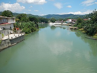
The Bumbungan River is a river in the province of Laguna in the Philippines. It is commonly referred to as the Pagsanjan River because of the popularity of the municipality of Pagsanjan and Pagsanjan Falls, one of the province's tourist destinations. The municipality of Pagsanjan was named so because it is where the Balanac River, originating from Mount Banahaw, joins the Bumbungan. Its old name, Pinagsangahan, which literally means branching, was changed to Pagsanjan during the Spanish Colonial Era.

San Juan Creek, also called the San Juan River, is a 29-mile (47 km) long stream in Orange and Riverside Counties, draining a watershed of 133.9 square miles (347 km2). Its mainstem begins in the southern Santa Ana Mountains in the Cleveland National Forest. It winds west and south through San Juan Canyon, and is joined by Arroyo Trabuco as it passes through San Juan Capistrano. It flows into the Pacific Ocean at Doheny State Beach. State Route 74, the Ortega Highway, crosses the Santa Ana Mountains via San Juan Canyon.
The Morong River, also known as the Morong–Teresa River, is a river system in Rizal, Philippines. It is one of 21 major tributaries of Laguna de Bay. It covers 14 barangays and stretches 10 kilometres (6.2 mi) from Antipolo down to Teresa, Rizal, Morong, Rizal and finally to Laguna de Bay.

The Santa Cruz River is a river system in Santa Cruz, Laguna, on the island of Luzon, in the Philippines.

The San Cristobal River, commonly known as the Matang Tubig River, is a river system in the cities of Calamba and Cabuyao, Laguna, Philippines. The river is one of 21 major tributaries of Laguna de Bay.
The Sapang Baho River is a river system that runs through Rizal Province and Marikina in the Philippines. The name, when literally translated, means "smelly creek". It is one of 21 tributaries of Laguna de Bay and is regularly monitored by the Laguna Lake Development Authority (LLDA) through one of its 15 river monitoring stations. Among its headwaters are the Hinulugang Taktak falls on the Taktak River in Antipolo city, once a famed tourist destination in the days before urbanization and pollution.

The Pangil River, also known as the Bambang Hari River, is a river system that runs through Pangil, Laguna, in the Philippines. It is one of 21 River tributaries of Laguna de Bay and is regularly monitored by the Laguna Lake Development Authority(LLDA) through one of its 15 river monitoring stations.

The Siniloan River, also known as the Romelo River, is a river system that runs through Siniloan, Laguna on the island of Luzon, in the Philippines. It is one of 21 tributaries of Laguna de Bay and is regularly monitored by the Laguna Lake Development Authority (LLDA) through one of its 15 river monitoring stations.

Santiago Creek is a major watercourse in Orange County in the U.S. state of California. About 34 miles (55 km) long, it drains most of the northern Santa Ana Mountains and is a tributary to the Santa Ana River. It is one of the longest watercourses entirely within the county. The creek shares its name with Santiago Peak, at 5,687 ft (1,733 m) the highest point in Orange County, on whose slopes its headwaters rise.

San Diego Creek is a 16-mile (26 km) urban waterway flowing into Upper Newport Bay in Orange County, California, United States. Its watershed covers 112.2 square miles (291 km2) in parts of eight cities, including Irvine, Tustin, and Costa Mesa. From its headwaters in Laguna Woods the creek flows northwest to its confluence with Peters Canyon Wash, where it turns abruptly southwest towards the bay. Most of the creek has been converted to a concrete flood control channel, but it also provides important aquatic and riparian habitat along its course and its tidal estuary.

Sulphur Creek is an approximately 4.5-mile (7.2 km) tributary of Aliso Creek in Orange County, California. The creek drains about 6 square miles (16 km2) in the suburban cities of Laguna Niguel and Laguna Hills. Although most of its watershed has been utilized for master planned residential development, the creek retains a natural channel with riparian and wetland habitat in parts of Laguna Niguel Regional Park and Aliso and Wood Canyons Regional Park. Urban runoff has changed the once seasonal creek into a perennial stream.
Costa Rica is divided into three major drainage basins encompassing 34 watersheds with numerous rivers and tributaries, one major lake used for hydroelectric generation, and two major aquifers that serve to store 90% of the municipal, industrial, and agricultural water supply needs of Costa Rica. Agriculture is the largest water user demanding around 53% of total supplies while the sector contributes 6.5% to the Costa Rica GDP. About a fifth of land under cultivation is being irrigated by surface water. Hydroelectric power generation makes up a significant portion of electricity usage in Costa Rica and much of this comes from the Arenal dam.
Water resources management in Nicaragua is carried out by the National water utility and regulated by the Nicaraguan Institute of water. Nicaragua has ample water supplies in rivers, groundwater, lagoons, and significant rainfall. Distribution of rainfall is uneven though with more rain falling on an annual basis in the Caribbean lowlands and much lower amounts falling in the inland areas. Significant water resources management challenges include contaminated surface water from untreated domestic and industrial wastewater, and poor overall management of the available water resources.


