Laguna, officially the Province of Laguna, is a province in the Philippines located in the Calabarzon region in Luzon. Its capital is Santa Cruz while its largest city is the City of Calamba and the province is situated southeast of Metro Manila, south of the province of Rizal, west of Quezon, north of Batangas and east of Cavite. Laguna hugs the southern shores of Laguna de Bay, the largest lake in the country. As of the 2020 census, the total population of Laguna is 3,382,193. Among all 82 provinces in the Philippines, Laguna accounted for the largest share (5%) of the national Gross Domestic Product (GDP) with a total of Php 990.69 billion in 2022.

Laguna de Bay, also known as Laguna Lake and alternatively spelled "Laguna de Bae", is the largest lake in the Philippines. It is located southeast of Metro Manila, between the provinces of Laguna to the south and Rizal to the north. A freshwater lake, it has a surface area of 911–949 km2, with an average depth of about 2.8 meters and an elevation of about one meter above sea level. The lake is shaped like a crow's foot, with two peninsulas jutting out from the northern shore and filling the large volcanic Laguna Caldera. In the middle of the lake is the large island of Talim.

The Pasig River is a water body in the Philippines that connects Laguna de Bay to Manila Bay. Stretching for 25.2 kilometers (15.7 mi), it bisects the Philippine capital of Manila and its surrounding urban area into northern and southern halves. Its major tributaries are the Marikina River and San Juan River. The total drainage basin of the Pasig River, including the basin of Laguna de Bay, covers 4,678 square kilometers (1,806 sq mi).

Taguig, officially the City of Taguig, is a coastal city located in eastern shores of Metro Manila. It is the fifth-most populous city in the Philippines with a population of 1.2 million people. The city is one of the Philippines' cultural, financial, high-tech, entertainment and media centers with significant influence on commerce, health care, research, technology, education, politics, tourism, dining, art, fashion, and sports. Taguig is also an important center for the country's international diplomacy, hosting several embassies. The city also home to the headquarters of several major multinational corporations. Taguig has the fourth largest skyline in the Philippines, with 289 high-rises, 80 of which exceed 100 m (328 ft).
Los Baños, officially the Municipality of Los Baños, colloquialy 'elbi' or simply LB, is a 1st class municipality in the province of Laguna, Philippines. According to the 2020 census, it has a population of 115,353 people.

Bay, officially the Municipality of Bay, and colloquially known as Bae, is a 2nd class municipality in the province of Laguna, Philippines. According to the 2020 census, it has a population of 67,182 people.

Pangil, officially the Municipality of Pangil, is a 4th class municipality in the province of Laguna, Philippines. According to the 2020 census, it has a population of 25,026 people.

Santa Cruz, officially the Municipality of Santa Cruz, is a 1st class municipality and capital of the province of Laguna, Philippines. According to the 2020 census, it has a population of 123,574 people.
The Laguna Lake Development Authority (LLDA), one of the attached agencies of the Department of Environment and Natural Resources (DENR), is responsible for the preservation, development, and sustainability of Laguna de Bay and its 21 major tributary rivers.

The Bay River, also known as the Sapang River and the San Nicolas River, is a river system in Bay, Laguna, Philippines. It is one of 21 major tributaries of Laguna de Bay and is the more southern of two small rivers that hem the town proper of Bay.
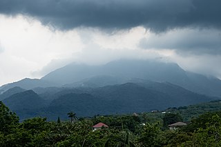
The Bumbungan River is a river in the province of Laguna in the Philippines. It is commonly referred to as the Pagsanjan River because of the popularity of the municipality of Pagsanjan and Pagsanjan Falls, one of the province's tourist destinations. The municipality of Pagsanjan was named so because it is where the Balanac River, originating from Mount Banahaw, joins the Bumbungan. Its old name, Pinagsangahan, which literally means branching, was changed to Pagsanjan during the Spanish Colonial Era.
The Morong River, also known as the Morong–Teresa River, is a river system in Rizal, Philippines. It is one of 21 major tributaries of Laguna de Bay. It covers 14 barangays and stretches 10 kilometres (6.2 mi) from Antipolo down to Teresa, Rizal, Morong, Rizal and finally to Laguna de Bay.

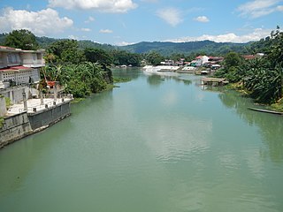
The Santa Cruz River is a river system in Santa Cruz, Laguna, on the island of Luzon, in the Philippines.

The San Cristobal River, commonly known as the Matang Tubig River, is a river system in the cities of Calamba and Cabuyao, Laguna, Philippines. The river is one of 21 major tributaries of Laguna de Bay.
The Sapang Baho River is a river system that runs through Rizal Province and Marikina in the Philippines. The name, when literally translated, means "smelly creek". It is one of 21 tributaries of Laguna de Bay and is regularly monitored by the Laguna Lake Development Authority (LLDA) through one of its 15 river monitoring stations. Among its headwaters are the Hinulugang Taktak falls on the Taktak River in Antipolo city, once a famed tourist destination in the days before urbanization and pollution.
The San Juan River, also known as the Calamba River, is a river system in Calamba, Laguna, Philippines. It is one of 21 major tributaries of Laguna de Bay and is regularly monitored by the Laguna Lake Development Authority (LLDA) through one of its 15 river monitoring stations.

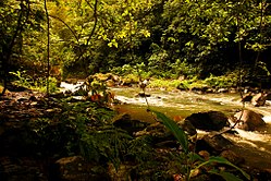
The Molawin River, also referred to as the Molawin Creek, is one of the many low volume flowing rocky streams crisscrossing the campus of the University of the Philippines Los Baños and some areas of the town of Los Baños. Molawin Creek crosses the whole of the UPLB campus and essentially cuts it in half making it necessary to construct several bridges throughout the university's history to improve the campus' integrity and general accessibility. Volume of flow depends on the average rainfall of the season and develops into a raging river during typhoons or heavy rainfall. It is a minor tributary of Laguna Lake, one among many small creeks that empty into Laguna de Bay. The origins of Molawin Creek and the other creeks in Los Baños have not been pinpointed but are generally accepted to have their origins high up in Mount Makiling. The name Molawin is a local variation of the name of the Molave tree.

The Siniloan River, also known as the Romelo River, is a river system that runs through Siniloan, Laguna on the island of Luzon, in the Philippines. It is one of 21 tributaries of Laguna de Bay and is regularly monitored by the Laguna Lake Development Authority (LLDA) through one of its 15 river monitoring stations.

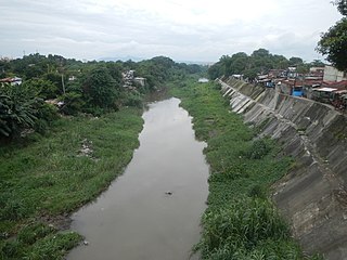
The Pasig River is a river in the Philippines running through the heart of Manila. It flows from Laguna de Bay to Manila Bay for 26 kilometers (16 mi). Its average width is 50 meters (160 ft) and average depth around 4–6 meters (13–20 ft). The river runs through some of the most populated areas in the Philippines.

The Nuestra Señora dela Natividad Parish Church, commonly known as Pangil Church, is a Roman Catholic church in Natividad, Pangil, Laguna, Philippines. It is under the jurisdiction of the Diocese of San Pablo. The statue of the pregnant Virgin Mary is said to be a gift from King Carlos III of Spain.