
Laguna, officially the Province of Laguna, is a province in the Philippines located in the Calabarzon region in Luzon. Its capital is Santa Cruz while its largest city is the City of Calamba and the province is situated southeast of Metro Manila, south of the province of Rizal, west of Quezon, north of Batangas and east of Cavite. Laguna hugs the southern shores of Laguna de Bay, the largest lake in the country. As of the 2020 census, the province's total population is 3,382,193. It is the seventh richest province in the country in 2016.

Laguna de Bay, also known as Laguna Lake and alternatively spelled "Laguna de Bae", is the largest lake in the Philippines. It is located southeast of Metro Manila, between the provinces of Laguna to the south and Rizal to the north. A freshwater lake, it has a surface area of 911–949 km2, with an average depth of about 2.8 meters and an elevation of about one meter above sea level. The lake is shaped like a crow's foot, with two peninsulas jutting out from the northern shore and filling the large volcanic Laguna Caldera. In the middle of the lake is the large island of Talim.

Cavinti, officially the Municipality of Cavinti, is a 3rd class municipality in the province of Laguna, Philippines. According to the 2020 census, it has a population of 23,980 people.

Liliw, officially the Municipality of Liliw, is a 4th class municipality in the province of Laguna, Philippines. According to the 2020 census, it has a population of 39,491 people.

Lumban, officially the Municipality of Lumban, is a 3rd class municipality in the province of Laguna, Philippines. According to the 2020 census, it has a population of 32,330 people.

Santa Cruz, officially the Municipality of Santa Cruz, is a 1st class municipality and capital of the province of Laguna, Philippines. According to the 2020 census, it has a population of 123,574 people.
The Marikina River is a river in eastern Metro Manila, Philippines. It is the largest tributary of the Pasig River, with headwaters located in the Sierra Madre Mountains in Rodriguez, Rizal province.

The environmental impact of reservoirs comes under ever-increasing scrutiny as the global demand for water and energy increases and the number and size of reservoirs increases.
The Bumbungan River is a river in the province of Laguna in the Philippines. It is commonly referred to as the Pagsanjan River because of the popularity of the municipality of Pagsanjan and Pagsanjan Falls, one of the province's tourist destinations. The municipality of Pagsanjan was named so because it is where the Balanac River, originating from Mount Banahaw, joins the Bumbungan. Its old name, Pinagsangahan, which literally means branching, was changed to Pagsanjan during the Spanish Colonial Era.

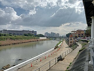
The San Cristobal River, commonly known as the Matang Tubig River, is a river system in the cities of Calamba and Cabuyao, Laguna, Philippines. The river is one of 21 major tributaries of Laguna de Bay.
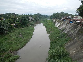
The Sapang Baho River is a river system that runs through Rizal Province and Marikina in the Philippines. The name, when literally translated, means "smelly creek". It is one of 21 tributaries of Laguna de Bay and is regularly monitored by the Laguna Lake Development Authority (LLDA) through one of its 15 river monitoring stations. Among its headwaters are the Hinulugang Taktak falls on the Taktak River in Antipolo city, once a famed tourist destination in the days before urbanization and pollution.
The San Juan River, also known as the Calamba River, is a river system in Calamba, Laguna, Philippines. It is one of 21 major tributaries of Laguna de Bay and is regularly monitored by the Laguna Lake Development Authority (LLDA) through one of its 15 river monitoring stations.

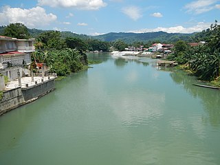
The Pangil River, also known as the Bambang Hari River, is a river system that runs through Pangil, Laguna, in the Philippines. It is one of 21 River tributaries of Laguna de Bay and is regularly monitored by the Laguna Lake Development Authority(LLDA) through one of its 15 river monitoring stations.

The Siniloan River, also known as the Romelo River, is a river system that runs through Siniloan, Laguna on the island of Luzon, in the Philippines. It is one of 21 tributaries of Laguna de Bay and is regularly monitored by the Laguna Lake Development Authority (LLDA) through one of its 15 river monitoring stations.
While Peru accounts for about four per cent of the world's annual renewable water resources, over 98% of its water is available east of the Andes, in the Amazon region. The coastal area of Peru, with most of economic activities and more than half of the population, receives only 1.8% of the national freshwater renewable water resources. Economic and population growth are taking an increasing toll on water resources quantity and quality, especially in the coastal area of Peru.

Magat Dam is a large rock-fill dam in the island of Luzon in the Philippines. The dam is located along the Magat River, a major tributary of the Cagayan River. The construction of the dam started in 1975 and was completed in 1982. It is one of the largest dams in the Philippines. It is a multi-purpose dam which is used primarily for irrigating about 85,000 hectares of agricultural lands, flood control, and power generation through the Magat Hydroelectric Power Plant.
The Saskatchewan River Sturgeon Management Board (SRSMB) advises the governments of Canada, Manitoba, Saskatchewan and First Nations on all matters related to sturgeon management on the Saskatchewan River between the Grand Rapids and E.B. Campbell dams.

Typhoon Parma, known in the Philippines as Super Typhoon Pepeng, was the second-wettest typhoon to affect the Philippines, and the second typhoon to affect the country within the span of a week during September 2009.
Water resources management in modern Egypt, is a complex process that involves multiple stakeholders who use water for irrigation, municipal and industrial water supply, hydropower generation and navigation. In addition, the waters of the Nile support aquatic ecosystems that are threatened by abstraction and pollution. Egypt also has substantial fossil groundwater resources in the Western Desert.

The Pantabangan–Carranglan Watershed Forest Reserve is a conservation area located in the upper reaches of the Pampanga River in Nueva Ecija, Philippines, and borders the Sierra Madre and Caraballo Mountains in Aurora and Nueva Vizcaya. It encompasses 84,500 hectares of the drainage basin surrounding the Pantabangan Lake, an impoundment of the Pampanga River by the Pantabangan Dam. The multi-purpose dam is situated at the confluence of Pampanga River's two headwaters, namely the Pantabangan and Carranglan Rivers in the municipality of Pantabangan. It stretches above the dam site for 21 kilometres (13 mi) to where Carranglan River originates in the Caraballo on the north, and for 18 kilometres (11 mi) to where Pantabangan River originates in the Sierra Madre on the east. It is considered a critical watershed for the agricultural economy and hydroelectric power generation in the region of Central Luzon.


