
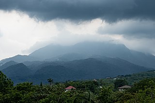
Calabarzon, sometimes referred to as Southern Tagalog and designated as Region IV‑A, is an administrative region in the Philippines. The region comprises five provinces: Batangas, Cavite, Laguna, Quezon, and Rizal; and one highly urbanized city, Lucena. It is the most populous region in the Philippines, according to the Philippine Statistics Authority (PSA), having over 16.1 million inhabitants in 2020, and is also the country's second most densely populated after the National Capital Region. It is situated southeast of Metro Manila, and is bordered by Manila Bay and South China Sea to the west, Lamon Bay and the Bicol Region to the east, Tayabas Bay and the Sibuyan Sea to the south, and Central Luzon to the north. It is home to places like Mount Makiling near Los Baños, Laguna, and Taal Volcano in Batangas. Calamba is the regional center while Antipolo is the most populous city in the region.

Laguna de Bay, also known as Laguna Lake and alternatively spelled "Laguna de Bae", is the largest lake in the Philippines. It is located southeast of Metro Manila, between the provinces of Laguna to the south and Rizal to the north. A freshwater lake, it has a surface area of 911–949 km2, with an average depth of about 2.8 meters and an elevation of about one meter above sea level. The lake is shaped like a crow's foot, with two peninsulas jutting out from the northern shore and filling the large volcanic Laguna Caldera. In the middle of the lake is the large island of Talim.

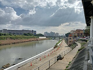
The Pasig River is a water body in the Philippines that connects Laguna de Bay to Manila Bay. Stretching for 25.2 kilometers (15.7 mi), it bisects the Philippine capital of Manila and its surrounding urban area into northern and southern halves. Its major tributaries are the Marikina River and San Juan River. The total drainage basin of the Pasig River, including the basin of Laguna de Bay, covers 4,678 square kilometers (1,806 sq mi).
Los Baños, officially the Municipality of Los Baños, colloquialy 'elbi' or simply LB, is a 1st class municipality in the province of Laguna, Philippines. According to the 2020 census, it has a population of 115,353 people.

Bay, officially the Municipality of Bay, and colloquially known as Bae, is a 2nd class municipality in the province of Laguna, Philippines. According to the 2020 census, it has a population of 67,182 people.

Calauan, officially the Municipality of Calauan, is a 2nd class municipality in the province of Laguna, Philippines. The municipality has a land area of 25.25 square miles which constitutes 3.41% of Laguna's total area. According to the 2020 census, it has a population of 87,693 people.

Lumban, officially the Municipality of Lumban, is a 3rd class municipality in the province of Laguna, Philippines. According to the 2020 census, it has a population of 32,330 people.

Pangil, officially the Municipality of Pangil, is a 4th class municipality in the province of Laguna, Philippines. According to the 2020 census, it has a population of 25,026 people.

Santa Cruz, officially the Municipality of Santa Cruz, is a 1st class municipality and capital of the province of Laguna, Philippines. According to the 2020 census, it has a population of 123,574 people.

Siniloan, officially the Municipality of Siniloan, is a 2nd class municipality in the province of Laguna, Philippines. According to the 2020 census, it has a population of 39,460 people.

Cabuyao, officially the City of Cabuyao, is a 1st class component city in the province of Laguna, Philippines. According to the 2020 census, it has a population of 355,330 people.

Tanay, officially the Municipality of Tanay, is a 1st class municipality in the province of Rizal, Philippines. According to the 2020 census, it has a population of 139,420 people.

General Mariano Alvarez, officially the Municipality of General Mariano Alvarez and often shortened as GMA, is a 1st class municipality in the province of Cavite, Philippines. According to the 2020 census, it has a population of 172,433 people.

Lopez, officially the Municipality of Lopez, is a 1st class municipality in the province of Quezon, Philippines. According to the 2020 census, it has a population of 94,657 people.

The Tagalog people are an Austronesian ethnic group native to the Philippines, particularly the Metro Manila and Calabarzon regions and Marinduque province of southern Luzon, and comprise the majority in the provinces of Bulacan, Bataan, Nueva Ecija, Aurora, and Zambales in Central Luzon and the island of Mindoro.
The Marikina River is a river in eastern Metro Manila, Philippines. It is the largest tributary of the Pasig River, with headwaters located in the Sierra Madre Mountains in Rodriguez, Rizal province.
The Morong River, also known as the Morong–Teresa River, is a river system in Rizal, Philippines. It is one of 21 major tributaries of Laguna de Bay. It covers 14 barangays and stretches 10 kilometres (6.2 mi) from Antipolo down to Teresa, Rizal, Morong, Rizal and finally to Laguna de Bay.

In early Philippine history, the Tagalog and Kapampangan settlement at Tondo, sometimes referred to as the Kingdom of Tondo, was a major trade hub located on the northern part of the Pasig River delta on Luzon island. Together with Maynila, the polity (bayan) that was also situated on the southern part of the Pasig River delta, Tondo had established a shared monopoly on the trade of Chinese goods throughout the rest of the Philippine archipelago, making it an established force in trade throughout Southeast Asia and East Asia.

In early Philippine history, barangay is the term historically used by scholars to describe the complex sociopolitical units that were the dominant organizational pattern among the various peoples of the Philippine archipelago in the period immediately before the arrival of European colonizers. Academics refer to these settlements using the technical term "polity", but they are usually simply called "barangays".

The Upper Marikina River Basin Protected Landscape is a protected area in the Province of Rizal in the Philippines, which forms the upper area of the drainage basin of the Marikina River.


