
Laguna, officially the Province of Laguna, is a province in the Philippines located in the Calabarzon region in Luzon. Its capital is Santa Cruz while its largest city is the City of Calamba and the province is situated southeast of Metro Manila, south of the province of Rizal, west of Quezon, north of Batangas and east of Cavite. Laguna hugs the southern shores of Laguna de Bay, the largest lake in the country. As of the 2020 census, the total population of Laguna is 3,382,193. Among all 82 provinces in the Philippines, Laguna accounted for the largest share (5%) of the national Gross Domestic Product (GDP) with a total of Php 990.69 billion in 2022.

Laguna de Bay, also known as Laguna Lake and alternatively spelled "Laguna de Bae", is the largest lake in the Philippines. It is located southeast of Metro Manila, between the provinces of Laguna to the south and Rizal to the north. A freshwater lake, it has a surface area of 911–949 km2, with an average depth of about 2.8 meters and an elevation of about one meter above sea level. The lake is shaped like a crow's foot, with two peninsulas jutting out from the northern shore and filling the large volcanic Laguna Caldera. In the middle of the lake is the large island of Talim.

The Pasig River is a water body in the Philippines that connects Laguna de Bay to Manila Bay. Stretching for 25.2 kilometers (15.7 mi), it bisects the Philippine capital of Manila and its surrounding urban area into northern and southern halves. Its major tributaries are the Marikina River and San Juan River. The total drainage basin of the Pasig River, including the basin of Laguna de Bay, covers 4,678 square kilometers (1,806 sq mi).
Los Baños, officially the Municipality of Los Baños, colloquialy 'elbi' or simply LB, is a 1st class municipality in the province of Laguna, Philippines. According to the 2020 census, it has a population of 115,353 people.

Siniloan, officially the Municipality of Siniloan, is a 2nd class municipality in the province of Laguna, Philippines. According to the 2020 census, it has a population of 39,460 people.

Alameda Creek is a large perennial stream in the San Francisco Bay Area. The creek runs for 45 miles (72 km) from a lake northeast of Packard Ridge to the eastern shore of San Francisco Bay by way of Niles Canyon and a flood control channel. Along its course, Alameda Creek provides wildlife habitat, water supply, a conduit for flood waters, opportunities for recreation, and a host of aesthetic and environmental values. The creek and three major reservoirs in the watershed are used as water supply by the San Francisco Public Utilities Commission, Alameda County Water District and Zone 7 Water Agency. Within the watershed can be found some of the highest peaks and tallest waterfall in the East Bay, over a dozen regional parks, and notable natural landmarks such as the cascades at Little Yosemite and the wildflower-strewn grasslands and oak savannahs of the Sunol Regional Wilderness.

The Laguna de Santa Rosa is a 22-mile-long (35 km) wetland complex that drains a 254-square-mile (660 km2) watershed encompassing most of the Santa Rosa Plain in Sonoma County, California, United States.
The Laguna Lake Development Authority (LLDA), one of the attached agencies of the Department of Environment and Natural Resources (DENR), is responsible for the preservation, development, and sustainability of Laguna de Bay and its 21 major tributary rivers.
The Marikina River is a river in eastern Metro Manila, Philippines. It is the largest tributary of the Pasig River, with headwaters located in the Sierra Madre Mountains in Rodriguez, Rizal province.

The Bay River, also known as the Sapang River and the San Nicolas River, is a river system in Bay, Laguna, Philippines. It is one of 21 major tributaries of Laguna de Bay and is the more southern of two small rivers that hem the town proper of Bay.
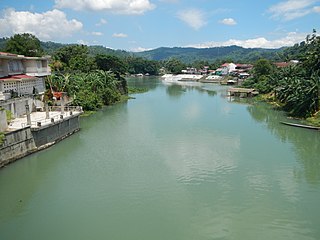
The Bumbungan River is a river in the province of Laguna in the Philippines. It is commonly referred to as the Pagsanjan River because of the popularity of the municipality of Pagsanjan and Pagsanjan Falls, one of the province's tourist destinations. The municipality of Pagsanjan was named so because it is where the Balanac River, originating from Mount Banahaw, joins the Bumbungan. Its old name, Pinagsangahan, which literally means branching, was changed to Pagsanjan during the Spanish Colonial Era.
The Morong River, also known as the Morong–Teresa River, is a river system in Rizal, Philippines. It is one of 21 major tributaries of Laguna de Bay. It covers 14 barangays and stretches 10 kilometres (6.2 mi) from Antipolo down to Teresa, Rizal, Morong, Rizal and finally to Laguna de Bay.

The Santa Cruz River is a river system in Santa Cruz, Laguna, on the island of Luzon, in the Philippines.

The San Cristobal River, commonly known as the Matang Tubig River, is a river system in the cities of Calamba and Cabuyao, Laguna, Philippines. The river is one of 21 major tributaries of Laguna de Bay.
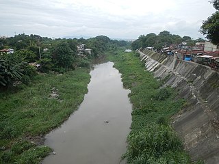
The Sapang Baho River is a river system that runs through Rizal Province and Marikina in the Philippines. The name, when literally translated, means "smelly creek". It is one of 21 tributaries of Laguna de Bay and is regularly monitored by the Laguna Lake Development Authority (LLDA) through one of its 15 river monitoring stations. Among its headwaters are the Hinulugang Taktak falls on the Taktak River in Antipolo city, once a famed tourist destination in the days before urbanization and pollution.
The San Juan River, also known as the Calamba River, is a river system in Calamba, Laguna, Philippines. It is one of 21 major tributaries of Laguna de Bay and is regularly monitored by the Laguna Lake Development Authority (LLDA) through one of its 15 river monitoring stations.

The Molawin River, also referred to as the Molawin Creek, is one of the many low volume flowing rocky streams crisscrossing the campus of the University of the Philippines Los Baños and some areas of the town of Los Baños. Molawin Creek crosses the whole of the UPLB campus and essentially cuts it in half making it necessary to construct several bridges throughout the university's history to improve the campus' integrity and general accessibility. Volume of flow depends on the average rainfall of the season and develops into a raging river during typhoons or heavy rainfall. It is a minor tributary of Laguna Lake, one among many small creeks that empty into Laguna de Bay. The origins of Molawin Creek and the other creeks in Los Baños have not been pinpointed but are generally accepted to have their origins high up in Mount Makiling. The name Molawin is a local variation of the name of the Molave tree.

The Pangil River, also known as the Bambang Hari River, is a river system that runs through Pangil, Laguna, in the Philippines. It is one of 21 River tributaries of Laguna de Bay and is regularly monitored by the Laguna Lake Development Authority(LLDA) through one of its 15 river monitoring stations.

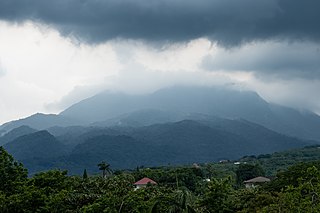
Tadlac Lake, also colloquially known as Crocodile Lake, is a freshwater volcanic maar lake located in Barangay Tadlac, in the municipality of Los Baños, Laguna. The lake-filled maar is located along the southern shore of Laguna de Bay, the largest lake in the country, with Crocodile Lake protruding out of the shore of the larger lake. If not for its slightly-elevated crater rim, Crocodile Lake would be wholly engulfed by Laguna de Bay.

The Pantabangan–Carranglan Watershed Forest Reserve is a conservation area located in the upper reaches of the Pampanga River in Nueva Ecija, Philippines, and borders the Sierra Madre and Caraballo Mountains in Aurora and Nueva Vizcaya. It encompasses 84,500 hectares of the drainage basin surrounding the Pantabangan Lake, an impoundment of the Pampanga River by the Pantabangan Dam. The multi-purpose dam is situated at the confluence of Pampanga River's two headwaters, namely the Pantabangan and Carranglan Rivers in the municipality of Pantabangan. It stretches above the dam site for 21 kilometres (13 mi) to where Carranglan River originates in the Caraballo on the north, and for 18 kilometres (11 mi) to where Pantabangan River originates in the Sierra Madre on the east. It is considered a critical watershed for the agricultural economy and hydroelectric power generation in the region of Central Luzon.


