Solis railway station

Last updated
 Solis 
Philippine National Railways
PNR Solis Station.jpg
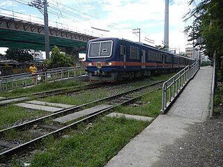
Exterior of Solis station
LocationSolis Street
Tondo, Manila
Coordinates 14°37′37.74″N120°58′32.10″E / 14.6271500°N 120.9755833°E / 14.6271500; 120.9755833 Coordinates: 14°37′37.74″N120°58′32.10″E / 14.6271500°N 120.9755833°E / 14.6271500; 120.9755833
Owned by Philippine National Railways
Line(s) PNR Northrail (1891-1997, 2018-present)
North Shuttle Line
Platforms Side platforms
Tracks1
Construction
Structure typeAt grade
Disabled accessYes
Other information
StatusOperational
History
OpenedAugust 1, 2018
Services
Preceding station  PNR  Following station
North Shuttle
toward  FTI
Metro North Commuter
Terminus
PNR Metro Commuter
North–South Commuter Line
BSicon exKBHFa orange.svg
Valenzuela
BSicon dWASSERq.svg
BSicon exSTR orange.svg
BSicon hKRZWae orange.svg
BSicon dWASSERq.svg
BSicon GRZq.svg
BSicon exSTR orange.svg
BSicon KACCa orange.svg
BSicon exSTR orange.svg
Governor Pascual
BSicon GRZq.svg
BSicon STR orange.svg
BSicon HSTACC orange.svg
Caloocan
BSicon ABZg+l orange.svgBSicon KDSTeq orange.svg
Caloocan Depot
BSicon HSTACC orange.svg
10th Avenue
BSicon HSTACC orange.svg
5th Avenue
BSicon GRZq.svg
BSicon STR orange.svg
BSicon dWASSERq.svgBSicon hKRZWae orange.svgBSicon dWASSERq.svg
Maypajo Estuary
BSicon HSTACC orange.svg
Solis
BSicon KDSTa orange.svgBSicon STR orange.svg
Tutuban Railyard &
Tayuman Locomotive Shed
BSicon ABZg+l orange.svg
BSicon ABZgl orange.svg
BSicon ABZg+r orange.svg
BSicon ABZgr orange.svg
BSicon KINTACCe orange.svgBSicon STR orange.svg
Tutuban
  2  
BSicon INTACC orange.svg
Blumentritt
  1  
BSicon HSTACC orange.svg
Laong Laan
BSicon lHSTACC.svg
BSicon eINTACC orange.svg
España
  8  
BSicon dWASSERq.svgBSicon hKRZWae orange.svgBSicon dWASSERq.svg
Valencia Estuary
BSicon INTACC orange.svg
Santa Mesa
  2  
BSicon dWASSERq.svgBSicon hKRZWae orange.svgBSicon dWASSERq.svg
Pandacan Estuary
BSicon HSTACC orange.svg
Pandacan
BSicon dWASSERq.svgBSicon hKRZWae orange.svgBSicon dWASSERq.svg
Pandacan Estuary
BSicon HSTACC orange.svg
Paco
BSicon HSTACC orange.svg
San Andres
BSicon HSTACC orange.svg
Vito Cruz
BSicon GRZq.svg
BSicon STR orange.svg
BSicon eHSTACC orange.svg
Buendia
BSicon HSTACC orange.svg
Dela Rosa
BSicon HSTACC orange.svg
Pasay Road
BSicon dWASSERq.svgBSicon hKRZWae orange.svgBSicon dWASSERq.svg
Tripa de Gallina Estuary
BSicon INTACC orange.svg
EDSA
  3  
BSicon dWASSERq.svgBSicon hKRZWae orange.svgBSicon dWASSERq.svg
Tripa de Gallina Estuary
BSicon INTACC orange.svg
Nichols BSicon FLUG.svg
  9  
BSicon INTACC orange.svg
FTI
  9  
BSicon GRZq.svg
BSicon STR orange.svg
BSicon HSTACC orange.svg
Bicutan
BSicon GRZq.svg
BSicon STR orange.svg
BSicon HSTACC orange.svg
Sucat
BSicon dWASSERq.svgBSicon hKRZWae orange.svgBSicon dWASSERq.svg
Sucat River
BSicon dWASSERq.svgBSicon hKRZWae orange.svgBSicon dWASSERq.svg
BSicon INTACC orange.svg
Alabang BSicon BUS2.svg
BSicon dWASSERq.svgBSicon hKRZWae orange.svgBSicon dWASSERq.svg
Bayanan Creek
BSicon dWASSERq.svgBSicon hKRZWae orange.svgBSicon dWASSERq.svg
Poblacion River
BSicon HSTACC orange.svg
Muntinlupa
BSicon dWASSERq.svgBSicon hKRZWae orange.svgBSicon dWASSERq.svg
Magdaong River
BSicon eHST orange.svg
Tunasan
BSicon GRZq.svg
BSicon STR orange.svg
BSicon dWASSERq.svgBSicon hKRZWae orange.svgBSicon dWASSERq.svg
Tunasan River
BSicon GRZq.svg
BSicon STR orange.svg
BSicon dWASSERq.svgBSicon hKRZWae orange.svgBSicon dWASSERq.svg
San Isidro River
BSicon HSTACC orange.svg
San Pedro
BSicon exKRW+l orange.svg
BSicon STR orange.svg
BSicon exKRWr orange.svg
BSicon GRZq.svg
BSicon exSTR orange.svg
BSicon STR orange.svg
BSicon exKBHFe orange.svgBSicon STR orange.svg
Carmona
BSicon HST orange.svg
Pacita MG
BSicon GRZq.svg
BSicon STR orange.svg
BSicon HST orange.svg
Golden City 1
BSicon HSTACC orange.svg
Biñan
BSicon dWASSERq.svgBSicon hKRZWae orange.svgBSicon dWASSERq.svg
Biñan River
BSicon GRZq.svg
BSicon STR orange.svg
BSicon dWASSERq.svgBSicon hKRZWae orange.svgBSicon dWASSERq.svg
Silang-Santa Rosa River
BSicon HSTACC orange.svg
Santa Rosa
BSicon eHST orange.svg
Golden City 2
BSicon GRZq.svg
BSicon STR orange.svg
BSicon dWASSERq.svgBSicon hKRZWae orange.svgBSicon dWASSERq.svg
Cabuyao River delta
BSicon HSTACC orange.svg
Cabuyao
BSicon eHST orange.svg
Gulod
BSicon dWASSERq.svgBSicon hKRZWae orange.svgBSicon dWASSERq.svg
Cabuyao River delta
BSicon ACC orange.svg
Mamatid
BSicon eHST orange.svg
Banlic
BSicon GRZq.svg
BSicon STR orange.svg
BSicon dWASSERq.svgBSicon hKRZWae orange.svgBSicon dWASSERq.svg
BSicon KACCe orange.svg
Calamba

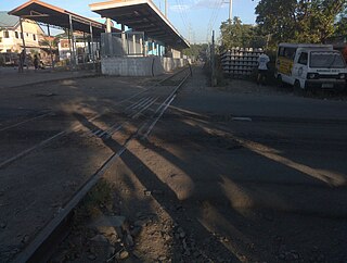
Solis station is a railway station of the Philippine National Railways as part of the Governor Pascual - FTI Line. Like all PNR stations, the station is at grade. It is located and situated along the railroad crossing on Solis St. in Tondo, Manila.

Philippine National Railways Railway company in the Philippines

The Philippine National Railways (PNR) is a state-owned railway company in the Philippines, operating a single line of track on Luzon. As of 2016, it operates one commuter rail service in Metro Manila and local services between Sipocot, Naga City and Legazpi City in the Bicol Region. PNR began operations on November 24, 1892 as the Ferrocarril de Manila-Dagupan, during the Spanish colonial period, and later becoming the Manila Railroad Company (MRR) during the American colonial period. It became the Philippine National Railways on June 20, 1964 by virtue of Republic Act No. 4156. The PNR is an agency of the Department of Transportation.

Tondo, Manila Place in National Capital Region, Philippines

Tondo is a district located in Manila, Philippines. It is the largest in terms of area and population of Manila's sixteen districts, with a Census-estimated 631,313 people in 2015 and consists of two congressional districts. It is also the most densely populated district in the city.

Manila Capital / Highly Urbanized City in National Capital Region, Philippines

Manila, officially the City of Manila, is the capital of the Philippines. As of 2018 it was the most densely populated city proper in the world. It was the first chartered city by virtue of the Philippine Commission Act 183 on July 31, 1901 and gained autonomy with the passage of Republic Act No. 409 or the "Revised Charter of the City of Manila" on June 18, 1949. Manila, alongside Mexico City and Madrid are considered the world's original set of Global Cities due to Manila's commercial networks being the first to traverse the Pacific Ocean, thus connecting Asia with the Spanish Americas, marking the first time in world history when an uninterrupted chain of trade routes circled the planet. Manila has been damaged by and rebuilt from wars more times than the famed city of Troy and it is also the second most natural disaster afflicted capital city in the world next to Tokyo yet it is simultaneously among the most populous and most wealthy cities in Southeast Asia.

Contents

After being abandoned for 20 years, and after nearly 10 years since the station's reconstruction, PNR reopened the Solis Station as part of Caloocan-Dela Rosa line, on August 1, 2018. [1] [2]

Due to nearly a decade of disuse since its rehabilitation, the station has been weathered and its gate barriers have been vandalized, and in the case of its westbound barrier, dismantled and possibly stolen. It did not have running electricity until after its reactivation.

This station was closed to rail traffic on 1997. On 2009, the station's new platforms were constructed but it was never opened until 2018 where it is once again active with the launching of the Caloocan-Dela Rosa shuttle line.

Notes

Solis, C-3 and Asistio Avenue stations originally lies on the old Manila-Dagupan Line, later the Manila-San Fernando Line, also known as the Main Line North. It will be revived as part of the revitalized Northrail that will initially serve Clark and Subic, and may eventually be rebuilt to revisit its original destination.

Clark Freeport and Special Economic Zone Freeport and Special Economic Zone in Central Luzon, Philippines

The Clark Freeport and Special Economic Zone (CFEZ) refers to an area spanning the city of Angeles and the provinces of Pampanga and Tarlac.

Subic Bay Freeport Zone Special Economic Zone in Central Luzon, Philippines

Subic Bay Freeport Zone (SBFZ), which is known simply as Subic Bay or Subic is a special economic zone covering portions of Olongapo City and the towns of Subic in Zambales and Morong and Hermosa in Bataan.It is the Philippines' first successful case of a military base converted through volunteerism into a tax and duty-free zone, operated and managed by the Subic Bay Metropolitan Authority or SBMA. It covers the fenced area of the former U.S. Naval Base Subic Bay located in the southwest of Luzon Island in the Philippines.The harbor faces the Zambales Mountain Range to the west and the Subic Bay opening to the South China Sea. It is northwest of the Bataan Peninsula and southeast of Zambales Province.

Rail skates and rickshaws run along the line, providing an alternate source of transportation, though before the construction of NLEX Segment 10.1. This was the only line to travel to the Caloocan railway depot.

North Luzon Expressway major controlled-access highway in the Philippines

The North Luzon Expressway, formerly known as the North Diversion Road and Manila North Expressway (MNEX), is a 4 to 8-lane limited-access toll expressway that connects Metro Manila to the provinces of the Central Luzon region in the Philippines. It is a component of Expressway 1 (E1) of the Philippine expressway network, Circumferential Road 5 (C-5) and Radial Road 8 (R-8) of Manila's arterial road network. It was built in the 1960s.

Station Layout

L1
Platforms
Side platform, doors will open on the left
Platform A PNR Metro Commuter towards FTI and Tutuban (←)
Platform B PNR Metro Commuter towards Governor Pascual (→)
L1Concourse/
Street Level
Ticket Booths, Station Control, Shops

Related Research Articles

Manila Metro Rail Transit System Line 3 The third rapid transit line of Metro Manila.

The Manila Metro Rail Transit System Line 3 also known as the MRT Line 3, MRT-3 or Metrostar Express is a rapid transit system of Metro Manila, Philippines. The line runs in an orbital north to south route following the alignment of the Epifanio de los Santos Avenue (EDSA). Although it has the characteristics of light rail, such as with the type of rolling stock used, it is more akin to a rapid transit system owing to its total grade separation and high passenger throughput.

Rail transport in the Philippines This is the system of rail transport in the Philippines

Rail transportation in the Philippines presently is used mostly to transport passengers within Metro Manila and the nearby province of Laguna. Freight transport is nonexistent, although there are plans for a revival from Port Area, Manila to Laguna, and a cargo train planned between Subic and Clark. Currently, the country has a railway footprint of only 79 kilometres through Line 1, Line 2, Line 3 and the Philippine National Railways (PNR) Metro Commuter Line. This situation will change in the immediate future as the government has plans to expand its current footprint to more than 244 kilometers.

Department of Transportation (Philippines)

The Department of Transportation is the executive department of the Philippine government responsible for the maintenance and expansion of viable, efficient, and dependable transportation systems as effective instruments for national recovery and economic progress.

San Fernando railway station (Pampanga)

San Fernando City station or simply San Fernando station is a defunct railway station of the PNR Northrail line of Philippine National Railways. It is situated San Fernando, Pampanga. Historically, the old PNR train station was the site of a stopping place for Filipino and American prisoners of war during the Bataan death march in 1942.

5th Avenue railway station

5th Avenue station is a railway station of the Philippine National Railways as part of Governor Pascual - FTI Line. Facilities such as ramps and platforms were planned to be constructed near the railway crossing with C-3 Road in Caloocan, Metro Manila. The plans to rehabilitate this part of PNR's network were implemented but no concrete platforms were erected.

EDSA railway station

EDSA station is a station on the South Main Line ("Southrail") of the Philippine National Railways. Like all PNR stations, this station is at grade. The station is located at the intersection of the South Luzon Expressway and Epifanio de los Santos Avenue in Makati, below the Magallanes Interchange.

FTI railway station

FTI station is a station of the South Main Line ("Southrail") of the Philippine National Railways. Like all PNR stations, this station is at grade. It is located on the East Service Road of the South Luzon Expressway in Taguig, on the foot of the Metro Manila Skyway. It is named after its major landmark, the grounds of the formerly state-owned Food Terminal, Inc. which is now renamed as Arca South.

Transportation in Metro Manila

The transportation system in Metro Manila is currently inadequate to accommodate the mobility and other basic needs of an densely populated metropolis, the result of many factors and problems that the government has failed to provide or address. Metro Manila exists in a state of near-permanent gridlock, with people and goods trapped by the very transportation system that is supposed to move them quickly and efficiently.

10th Avenue railway station

10th Avenue station is a railway station of the Philippine National Railways (PNR) as part of Governor Pascual - FTI Line. Like all PNR stations, the station is at grade. It is located on 10th Avenue in Caloocan, near the original Caloocan railway station.

Caloocan railway station

Caloocan railway station is a railway station of the Philippine National Railways (PNR) as part of the Governor Pascual - FTI line. It is rebuilt from its original location, now located and situated adjacent to Apolinario Mabini St., and along the railroad crossing on Samson Road in Caloocan, Metro Manila.

San Pedro railway station

San Pedro station is a railway station on the South Main Line (Southrail) of the Philippine National Railways. Like most of the PNR stations operating under Metro South Commuter, the station is at grade. It is located in San Pedro, Laguna, within the city proper.

PNR Metro Commuter Line

The Philippine National Railways Metro Commuter Line is a commuter rail line operated by the Philippine National Railways, stretching from Tondo, Manila to the southern and northern edge of Metro Manila. Presently, there are 31 railway stations. The current line is colored orange on most maps.

San Pedro-Carmona Resettlement station, often shortened to Carmona, was the terminus of the San Pedro-Carmona Line. The line was built to serve the San Pedro-Carmona Resettlement Center.

Metro Manila Subway Line 9 Under construction subway line in Metro Manila.

Metro Manila Subway Line 9, formerly known as the Mega Manila Subway, is an underground rapid transit line currently under construction in Metro Manila, Philippines. The 36-kilometer (22 mi) line, which will run north–south between the cities of Quezon City, Pasig, Makati, Taguig and Pasay, will serve fifteen stations between the Quirino Highway and FTI stations. It will also serve as the country's second direct airport rail link, with a branch line to Ninoy Aquino International Airport. The line is designed to connect with the other urban rail transit services in the region, including Line 1, Line 3, and Line 7 at the North Avenue Common station, which is also currently under construction; the existing Line 2 and Metro Commuter Line; and the planned Line 5 and Line 8.

Dela Rosa railway station

Dela Rosa is a station on the South Main Line ("Southrail") of the Philippine National Railways. Like all PNR stations, this station is at grade. The station is located at the corner of Dela Rosa Street and the South Luzon Expressway in Makati.

The Makati Intra-city Subway Line 5 is an 11-kilometer (6.8 mi) proposed underground rapid transit line to be located in Makati, Metro Manila, that will link establishments across the city's business district. It will be built under a public-private partnership program between the Makati City Government and a private consortium, IRC Properties Inc.. Proponents of the subway began construction in December 2018, and Makati Mayor Abigail Binay projects completion by the year 2025. The subway will cost $3.7 billion and is expected to accommodate 700,000 passengers daily. It will also have eleven stations, with connections to the existing Line 3, the Pasig River Ferry Service, and the approved Line 9.

Governor Pascual railway station Railway station in Malabon

Governor Pascual railway station is a railway station of the Philippine National Railways (PNR). It is located and situated adjacent to Governor Pascual Avenue, Barangay Acacia in Malabon, Metro Manila.

North–South Commuter Railway

The North–South Commuter Railway or NSCR, also known as the Clark–Calamba Railway, is a 147 kilometer elevated railway under construction. It will run from New Clark City in Capas, Tarlac to Calamba, Laguna, with a total of 36 stations. It will also feature the first direct airport link in the country, serving Clark International Airport.

References

  1. "20 YEARS AFTER: DOTr sees 10,000 passengers taking PNR's reopened Caloocan-Dela Rosa line". GMA News Online. Retrieved 2018-08-01.
  2. News, ABS-CBN. "After 20 years, PNR's Caloocan to Makati line to reopen". ABS-CBN News. Retrieved 2018-08-01.