Bicutan railway station

Last updated
 Bicutan 
Philippine National Railways
Philippine Railways- Bicutan.jpg
PNR kiha 52, leaving Bicutan station
LocationGeneral Santos Avenue
San Martin de Porres, Parañaque
Coordinates 14°29′14.94″N121°2′44.56″E / 14.4874833°N 121.0457111°E / 14.4874833; 121.0457111 Coordinates: 14°29′14.94″N121°2′44.56″E / 14.4874833°N 121.0457111°E / 14.4874833; 121.0457111
Owned by Philippine National Railways
Line(s) PNR Southrail
PlatformsSide platforms
Tracks2
Construction
Structure typeAt grade
Disabled accessYes
Other information
Station codeBIC
History
OpenedJanuary 19, 1977
Rebuilt2009
Services
Preceding station  PNR  Following station
FTI
toward  Tutuban
Metro South Commuter
toward  Calamba
PNR Metro Commuter
North-South Commuter Line
BSicon fexKBHFa.svg
Valenzuela
BSicon dWASSERq.svgBSicon fexWBRUCKE.svgBSicon dWASSERq.svg
BSicon GRZq.svg
BSicon fexSTR.svg
BSicon fKBHFa.svg
BSicon fexSTR.svg
BSicon GRZq.svg
BSicon fSTR.svg
BSicon fHST.svg
Caloocan
BSicon fHST.svg
10th Avenue
BSicon fHST.svg
5th Avenue
BSicon GRZq.svg
BSicon fSTR.svg
BSicon fHST.svg
Solis
BSicon STR+l orange.svg
BSicon fABZgl.svg
BSicon KBHFeq orange.svg
Tutuban
BSicon INT orange.svg
Blumentritt
  LRT1  
BSicon HST orange.svg
Laong Laan
BSicon HST orange.svg
España
BSicon INT orange.svg
Santa Mesa
  LRT2  
BSicon dWASSERq.svgBSicon WBRUCKE orange.svgBSicon dWASSERq.svg
BSicon HST orange.svg
Pandacan
BSicon HST orange.svg
Paco
BSicon HST orange.svg
San Andres
BSicon HST orange.svg
Vito Cruz
BSicon GRZq.svg
BSicon STR orange.svg
BSicon eHST orange.svg
Buendia
BSicon HST orange.svg
Dela Rosa
BSicon HST orange.svg
Pasay Road
BSicon INT orange.svg
EDSA
  MRT3  
BSicon GRZq.svg
BSicon STR orange.svg
BSicon HST orange.svg
Nichols
BSicon FLUG.svg
BSicon HST orange.svg
FTI
BSicon GRZq.svg
BSicon STR orange.svg
BSicon HST orange.svg
Bicutan
BSicon GRZq.svg
BSicon STR orange.svg
BSicon HST orange.svg
Sucat
BSicon BHF orange.svg
Alabang
BSicon HST orange.svg
Muntinlupa
BSicon eHST orange.svg
Tunasan
BSicon GRZq.svg
BSicon STR orange.svg
BSicon HST orange.svg
San Pedro
BSicon HST orange.svg
Pacita MG
BSicon GRZq.svg
BSicon STR orange.svg
BSicon HST orange.svg
Golden City 1
BSicon HST orange.svg
Biñan
BSicon GRZq.svg
BSicon STR orange.svg
BSicon HST orange.svg
Santa Rosa
BSicon eHST orange.svg
Golden City 2
BSicon GRZq.svg
BSicon STR orange.svg
BSicon HST orange.svg
Cabuyao
BSicon BHF orange.svg
Mamatid
BSicon eHST orange.svg
Banlic
BSicon GRZq.svg
BSicon STR orange.svg
BSicon dWASSERq.svgBSicon WBRUCKE orange.svgBSicon dWASSERq.svg
BSicon KBHFe orange.svg
Calamba

Bicutan station is a station on the South Main Line ("Southrail") of the Philippine National Railways. Like all PNR stations, this station is at grade. The station is located on General Santos Avenue in Parañaque, near the border with Taguig and beside the ramp for northbound vehicles entering the South Luzon Expressway.

Philippine National Railways Railway company in the Philippines

The Philippine National Railways (PNR) is a state-owned railway company in the Philippines, operating a single line of track on Luzon. As of 2016, it operates one commuter rail service in Metro Manila and local services between Sipocot, Naga City and Legazpi City in the Bicol Region. PNR began operations on November 24, 1892 as the Ferrocarril de Manila-Dagupan, during the Spanish colonial period, and later becoming the Manila Railroad Company (MRR) during the American colonial period. It became the Philippine National Railways on June 20, 1964 by virtue of Republic Act No. 4156. The PNR is an agency of the Department of Transportation.

Parañaque Highly Urbanized City in National Capital Region, Philippines

Parañaque, officially the City of Parañaque,, or simply known as Parañaque City, is a 1st class highly urbanized city in Metro Manila, Philippines. According to the 2015 census, it has a population of 665,822 people.

Taguig Highly Urbanized City in National Capital Region, Philippines

Taguig, officially the City of Taguig,, is a 1st class highly urbanized city in Metro Manila, Philippines. According to the 2015 census, it has a population of 804,915 people. The city is known for the Bonifacio Global City, one of the leading financial and lifestyle districts of the country, and Arca South, a planned unit development located at the site of the former Food Terminal Incorporated (FTI) in Western Bicutan. Taguig is also the home of SM Aura Premier, Market! Market!, the Department of Science and Technology, Manila American Cemetery, and the Heroes' Cemetery.

Contents

The station is the fourteenth station southbound from Tutuban and is the only PNR station in Parañaque.

Tutuban railway station a station of the Philippine National Railways (PNR)

Tutuban station commonly as Manila railway Station or Divisoria railway Station is the main train station of the Philippine National Railways (PNR) and the main train station of the city of Manila in the Philippines. It was formerly known as the Manila Railroad Company (MRRCo). The name refers to two stations: the original Tutuban station, which today forms part of the Tutuban Centermall, and the PNR Executive Building, which houses PNR offices and serves as the current terminus of all PNR services.

Nearby landmarks

The station is near major landmarks such as the Bicutan Public Market, the headquarters of the Department of Science and Technology (DOST), offices of the Philippine National Construction Corporation (PNCC) and SM City Bicutan. Further away from the station are the Polytechnic University of the Philippines, Taguig, Taguig City University, Camp Bagong Diwa and the Upper Bicutan National High School.

Department of Science and Technology (Philippines)

The Philippines' Department of Science and Technology, is the executive department of the Philippine Government responsible for the coordination of science and technology-related projects in the Philippines and to formulate policies and projects in the fields of science and technology in support of national development.

Philippine National Construction Corporation

The Philippine National Construction Corporation or PNCC is a government-owned and controlled corporation (GOCC) in the Philippines. It is the largest construction company in the Philippines and in Southeast Asia.

Upper Bicutan National High School Place in Department of Education, Philippines

Upper Bicutan National High School, commonly abbreviated as U.B.N.H.S is a secondary high school institution located at General Santos Avenue, Barangay Upper Bicutan, Taguig City in the Philippines.

Bicutan station is accessible by jeepneys plying the Lower Bicutan and East Service Road routes, as well as buses plying the South Luzon Expressway route which stop in Bicutan. A bus stop is located just outside the station.

SM City Bicutan is accessible by a pedestrian bridge overpassing the South Luzon Expressway. Nearby, the main tricycle terminal of Brgy. Don Bosco is located leading to major routes in Better Living Subdivision plus the whole barangay such as the National Shrine of Mary Help of Christians

South Luzon Expressway major controlled-access highway in the Philippines

The South Luzon Expressway, formerly known as the South Superhighway (SSH), Manila South Diversion Road (MSDR), and Manila South Expressway (MSEX), is a network of two expressways that connects Metro Manila to the provinces of the Calabarzon region in the Philippines. The first expressway is the Skyway, operated jointly by the Skyway Operation and Management Corporation (SomCo) and Citra Metro Manila Tollways Corporation (CMMTC). The second expressway, the South Luzon Tollway or Alabang–Calamba–Santo Tomas Expressway (ACTEx), is jointly operated by the South Luzon Tollway Corporation, a joint venture of the Philippine National Construction Corporation and the San Miguel Corporation-backed Citra group of Indonesia via the Manila Toll Expressway Systems, Inc. (MATES).

Station Layout

L1
Platforms
Side platform, doors will open on the right
Platform A PNR Metro Commuter towards Tutuban (←)
Platform B PNR Metro Commuter towards Alabang (→)
Side platform, doors will open on the right
L1Concourse/
Street Level
Ticket Booths, Station Control, Shops, Bicutan Public Market, Department of Science and Technology, Philippine National Construction Corporation, SM City Bicutan, Polytechnic University of the Philippines-Taguig, Taguig City University, Camp Bagong Diwa, Upper Bicutan National High School

Related Research Articles

EDSA LRT station station on the Manila LRT Yellow Line (LRT-1)

EDSA LRT station is a station on the Manila LRT (LRT-1). Like all other LRT-1 stations, EDSA station is above-ground. The station is located on the intersection of Taft Avenue and Epifanio de los Santos Avenue, or EDSA, one of Metro Manila's main thoroughfares. The station was named after EDSA, which in turn is named after Epifanio de los Santos, a noted historian.

Skyway (Metro Manila) road in the Philippines

Skyway, officially the Metro Manila Skyway System (MMSWS) or Metro Manila Skyway, is an elevated highway serving as the main expressway in southern Metro Manila, Philippines, following much of the existing South Luzon Expressway's alignment by going above it. It stretches from Gil Puyat Avenue in the north to Alabang–Zapote Road in the south and crosses through the highly urbanized areas of Makati, Pasay, Taguig, Parañaque, and Muntinlupa, relieving SLEx and other major thoroughfares from heavy traffic.

Magallanes MRT station station on the Manila MRT Blue Line (MRT-3)

Magallanes Station is a station on the Manila Metro Rail Transit System Line 3. It is one of the many elevated stations found on the line. The station is named after the Magallanes district of Makati, which in turn is named after Ferdinand Magellan, who discovered the Philippines for Spain on April 15, 1521. Although the station is named after Magallanes, it also serves passengers from barangays Kayamanan-C, Dasmariñas, Pio del Pilar, and San Lorenzo in Makati, and those from Taguig.

Circumferential Road 5 road in the Philippines

Circumferential Road 5, more commonly known as C-5 Road or C-5, is a network of roads and bridges that altogether forms a major route that transverses in Metro Manila, in the National Capital Region of the Philippines. It is also known officially as Carlos P. Garcia Avenue, and as National Route 11 (N11), National Route 128 (N128) and National Route 129 (N129) in the National Route Numbering System implemented in 2014. Expressway portions, part of the North Luzon Expressway Mindanao Avenue and Karuhatan Link, are numbered Expressway Route 5 (E5).

Santa Mesa railway station a station on the South Main Line (Southrail) of the Philippine National Railways

Santa Mesa station is a station on the South Main Line (Southrail) of the Philippine National Railways. Like all PNR stations, the station is at grade. It is located on an unnamed road near Ramon Magsaysay Boulevard in Santa Mesa, Manila, making it one of two stations to have its own access road. The station is named after the district where it is located.

Radial Road 3

Radial Road 3 (R-3) is a network of roads and bridges that altogether form the third arterial road of Manila in the Philippines. The road runs north-south linking the City of Manila to the southern Metro Manila cities of Makati, Pasay, Taguig, Parañaque and Muntinlupa, down to San Pedro, Biñan, Santa Rosa, Cabuyao and Calamba in the province of Laguna, all the way to the Southern Tagalog Arterial Road from Santo Tomas to Batangas City in the province of Batangas. The portion of R-3 from Epifanio de los Santos Avenue (EDSA) in Makati to Calamba also forms part of the Pan-Philippine Highway network (AH26).

Buendia railway station a station on the South Main Line ("Southrail") of the Philippine National Railways

Buendia was a station on the South Main Line ("Southrail") of the Philippine National Railways. Like all PNR stations, this station is at grade. The station was located at the corner of Gil Puyat Avenue and the South Luzon Expressway in Makati.

Nichols railway station

Nichols station is a station of the South Main Line ("Southrail") of the Philippine National Railways. Like all PNR stations, this station is at grade. It is located on the East Service Road of the South Luzon Expressway in Taguig, on the foot of the Sales Interchange, and takes its name from one of the area's popular nicknames, Nichols, which is also the former name of Villamor Airbase. It was opened for revenue service on March 25, 2010.

Vito Cruz railway station

Vito Cruz is a station on the South Main Line ("Southrail") of the Philippine National Railways. Like all PNR stations, this station is at grade. The station is located at the corner of Pablo Ocampo Street Extension and the South Luzon Expressway in San Andres, Manila, near the border with Makati City.

EDSA railway station

EDSA is a station on the South Main Line ("Southrail") of the Philippine National Railways. Like all PNR stations, this station is at grade. The station is located at the intersection of the South Luzon Expressway and Epifanio de los Santos Avenue in Makati, below the Magallanes Interchange.

San Andres railway station

San Andres station is a station of the South Main Line ("Southrail") of the Philippine National Railways. Like all PNR stations, this station is at grade. It is located at the intersection of Aviadores Street, San Andres Street and the South Luzon Expressway in San Andres, Manila.

Pasay Road railway station

Pasay Road is a station on the South Main Line ("Southrail") of the Philippine National Railways. Like all PNR stations, this station is at grade. The station is located on Estacion Street in Barangay Pio del Pilar in Makati, making it only one of two stations to have its own access road. It is named after Pasay Road, the old name of the Makati section of Arnaiz Avenue.

FTI railway station

FTI station is a station of the South Main Line ("Southrail") of the Philippine National Railways. Like all PNR stations, this station is at grade. It is located on the East Service Road of the South Luzon Expressway in Taguig, on the foot of the Metro Manila Skyway. It is named after its major landmark, the grounds of the formerly state-owned Food Terminal, Inc. which is now renamed as Arca South.

Sucat railway station

Sucat station is a station on the South Main Line ("Southrail") of the Philippine National Railways. Like all PNR stations, this station is at grade. The station is located on Meralco Road in Muntinlupa, near the South Luzon Expressway.

Alabang railway station a station on the South Main Line ("Southrail") of the Philippine National Railways

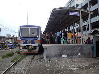
Alabang Station is a station on the South Main Line ("Southrail") of the Philippine National Railways. Like all PNR stations, this station is at grade. The station is located on T. Molina Street in Alabang, Muntinlupa, near the Alabang Viaduct of the South Luzon Expressway.

Doña Soledad Avenue is an east-west route in the southern Metro Manila city of Parañaque, Philippines. It is located in Don Bosco, Sun Valley and Moonwalk, which are Barangays located in northeastern Parañaque. It runs from its intersection with E. Rodriguez Avenue in the eastern edge of Moonwalk. The road continues to the east, entering Better Living Subdivision. It then curves north for a few blocks, then turns east and heads for its terminus at Doña Soledad interchange of South Luzon Expressway (SLEX) and the Manila Skyway. East of SLEX, the avenue enters Lower Bicutan, Taguig where it continues as General Santos Avenue.

Dela Rosa railway station

Dela Rosa is a station on the South Main Line ("Southrail") of the Philippine National Railways. Like all PNR stations, this station is at grade. The station is located at the corner of Dela Rosa Street and the South Luzon Expressway in Makati.