Vito Cruz railway station

Last updated
 Vito Cruz 
Philippine National Railways
PNR Vito Cruz renovated.jpg
Exterior of Vito Cruz station
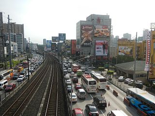
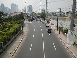
Location South Luzon Expressway cor. Pablo Ocampo Street Ext.
San Andres, Manila
Coordinates 14°34′1.56″N121°0′10.14″E / 14.5671000°N 121.0028167°E / 14.5671000; 121.0028167 Coordinates: 14°34′1.56″N121°0′10.14″E / 14.5671000°N 121.0028167°E / 14.5671000; 121.0028167
Owned by Philippine National Railways
Line(s) PNR Southrail
PlatformsSide platforms
Tracks2
Construction
Structure typeAt grade
Disabled accessYes
Other information
Station codeVTC
History
Opened1975
Rebuilt1990, 2009
Services
Preceding station  PNR  Following station
toward  Tutuban
Metro South Commuter
toward  Calamba
PNR Metro Commuter
North–South Commuter Line
BSicon exKBHFa orange.svg
Valenzuela
BSicon dWASSERq.svg
BSicon exSTR orange.svg
BSicon hKRZWae orange.svg
BSicon dWASSERq.svg
BSicon GRZq.svg
BSicon exSTR orange.svg
BSicon KACCa orange.svg
BSicon exSTR orange.svg
Governor Pascual
BSicon GRZq.svg
BSicon STR orange.svg
BSicon HSTACC orange.svg
Caloocan
BSicon ABZg+l orange.svgBSicon KDSTeq orange.svg
Caloocan Depot
BSicon HSTACC orange.svg
10th Avenue
BSicon HSTACC orange.svg
5th Avenue
BSicon GRZq.svg
BSicon STR orange.svg
BSicon dWASSERq.svgBSicon hKRZWae orange.svgBSicon dWASSERq.svg
Maypajo Estuary
BSicon HSTACC orange.svg
Solis
BSicon KDSTa orange.svgBSicon STR orange.svg
Tutuban Railyard &
Tayuman Locomotive Shed
BSicon ABZg+l orange.svg
BSicon ABZgl orange.svg
BSicon ABZg+r orange.svg
BSicon ABZgr orange.svg
BSicon KINTACCe orange.svgBSicon STR orange.svg
Tutuban
  2  
BSicon INTACC orange.svg
Blumentritt
  1  
BSicon HSTACC orange.svg
Laong Laan
BSicon lHSTACC.svg
BSicon eINTACC orange.svg
España
  8  
BSicon dWASSERq.svgBSicon hKRZWae orange.svgBSicon dWASSERq.svg
Valencia Estuary
BSicon INTACC orange.svg
Santa Mesa
  2  
BSicon dWASSERq.svgBSicon hKRZWae orange.svgBSicon dWASSERq.svg
Pandacan Estuary
BSicon HSTACC orange.svg
Pandacan
BSicon dWASSERq.svgBSicon hKRZWae orange.svgBSicon dWASSERq.svg
Pandacan Estuary
BSicon HSTACC orange.svg
Paco
BSicon HSTACC orange.svg
San Andres
BSicon HSTACC orange.svg
Vito Cruz
BSicon GRZq.svg
BSicon STR orange.svg
BSicon eHSTACC orange.svg
Buendia
BSicon HSTACC orange.svg
Dela Rosa
BSicon HSTACC orange.svg
Pasay Road
BSicon dWASSERq.svgBSicon hKRZWae orange.svgBSicon dWASSERq.svg
Tripa de Gallina Estuary
BSicon INTACC orange.svg
EDSA
  3  
BSicon dWASSERq.svgBSicon hKRZWae orange.svgBSicon dWASSERq.svg
Tripa de Gallina Estuary
BSicon INTACC orange.svg
Nichols BSicon FLUG.svg
  9  
BSicon INTACC orange.svg
FTI
  9  
BSicon GRZq.svg
BSicon STR orange.svg
BSicon HSTACC orange.svg
Bicutan
BSicon GRZq.svg
BSicon STR orange.svg
BSicon HSTACC orange.svg
Sucat
BSicon dWASSERq.svgBSicon hKRZWae orange.svgBSicon dWASSERq.svg
Sucat River
BSicon dWASSERq.svgBSicon hKRZWae orange.svgBSicon dWASSERq.svg
BSicon INTACC orange.svg
Alabang BSicon BUS2.svg
BSicon dWASSERq.svgBSicon hKRZWae orange.svgBSicon dWASSERq.svg
Bayanan Creek
BSicon dWASSERq.svgBSicon hKRZWae orange.svgBSicon dWASSERq.svg
Poblacion River
BSicon HSTACC orange.svg
Muntinlupa
BSicon dWASSERq.svgBSicon hKRZWae orange.svgBSicon dWASSERq.svg
Magdaong River
BSicon eHST orange.svg
Tunasan
BSicon GRZq.svg
BSicon STR orange.svg
BSicon dWASSERq.svgBSicon hKRZWae orange.svgBSicon dWASSERq.svg
Tunasan River
BSicon GRZq.svg
BSicon STR orange.svg
BSicon dWASSERq.svgBSicon hKRZWae orange.svgBSicon dWASSERq.svg
San Isidro River
BSicon HSTACC orange.svg
San Pedro
BSicon exKRW+l orange.svg
BSicon STR orange.svg
BSicon exKRWr orange.svg
BSicon GRZq.svg
BSicon exSTR orange.svg
BSicon STR orange.svg
BSicon exKBHFe orange.svgBSicon STR orange.svg
Carmona
BSicon HST orange.svg
Pacita MG
BSicon GRZq.svg
BSicon STR orange.svg
BSicon HST orange.svg
Golden City 1
BSicon HSTACC orange.svg
Biñan
BSicon dWASSERq.svgBSicon hKRZWae orange.svgBSicon dWASSERq.svg
Biñan River
BSicon GRZq.svg
BSicon STR orange.svg
BSicon dWASSERq.svgBSicon hKRZWae orange.svgBSicon dWASSERq.svg
Silang-Santa Rosa River
BSicon HSTACC orange.svg
Santa Rosa
BSicon eHST orange.svg
Golden City 2
BSicon GRZq.svg
BSicon STR orange.svg
BSicon dWASSERq.svgBSicon hKRZWae orange.svgBSicon dWASSERq.svg
Cabuyao River delta
BSicon HSTACC orange.svg
Cabuyao
BSicon eHST orange.svg
Gulod
BSicon dWASSERq.svgBSicon hKRZWae orange.svgBSicon dWASSERq.svg
Cabuyao River delta
BSicon ACC orange.svg
Mamatid
BSicon eHST orange.svg
Banlic
BSicon GRZq.svg
BSicon STR orange.svg
BSicon dWASSERq.svgBSicon hKRZWae orange.svgBSicon dWASSERq.svg
BSicon KACCe orange.svg
Calamba

Vito Cruz is a station on the South Main Line ("Southrail") of the Philippine National Railways. Like all PNR stations, this station is at grade. The station is located at the corner of Pablo Ocampo Street Extension (formerly named Vito Cruz Extension) and the South Luzon Expressway in San Andres, Manila, near the border with Makati City.

Philippine National Railways Railway company in the Philippines

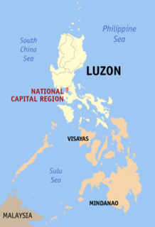
The Philippine National Railways (PNR) is a state-owned railway company in the Philippines, operating a single line of track on Luzon. As of 2016, it operates one commuter rail service in Metro Manila and local services between Sipocot, Naga City and Legazpi City in the Bicol Region. PNR began operations on November 24, 1892 as the Ferrocarril de Manila-Dagupan, during the Spanish colonial period, and later becoming the Manila Railroad Company (MRR) during the American colonial period. It became the Philippine National Railways on June 20, 1964 by virtue of Republic Act No. 4156. The PNR is an agency of the Department of Transportation.

Pablo Ocampo Street street in Metro Manila, Philippines

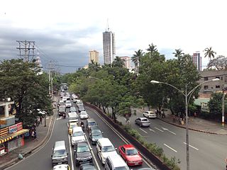
Pablo Ocampo Street is an inner city main road in Manila, Philippines. It runs west-east for about 3.4 kilometers connecting the southern districts of Malate and San Andres southeast to Makati.

South Luzon Expressway major controlled-access highway in the Philippines

The South Luzon Expressway, formerly known as the South Superhighway (SSH), Manila South Diversion Road (MSDR), and Manila South Expressway (MSEX), is a network of two expressways that connects Metro Manila to the provinces of the Calabarzon region in the Philippines. The first expressway is the Skyway, operated jointly by the Skyway Operation and Management Corporation (SomCo) and Citra Metro Manila Tollways Corporation (CMMTC). The second expressway, the South Luzon Tollway or Alabang–Calamba–Santo Tomas Expressway (ACTEx), is jointly operated by the South Luzon Tollway Corporation, a joint venture of the Philippine National Construction Corporation and the San Miguel Corporation-backed Citra group of Indonesia via the Manila Toll Expressway Systems, Inc. (MATES).

Contents

Vito Cruz is the eighth station from Tutuban and is the last station of the South Main Line physically located in the city of Manila.

Tutuban railway station a station of the Philippine National Railways (PNR)

Tutuban station commonly as Manila railway Station or Divisoria railway Station is the main train station of the Philippine National Railways (PNR) and the main train station of the city of Manila in the Philippines. It was formerly known as the Manila Railroad Company (MRRCo). The name refers to two stations: the original Tutuban station, which today forms part of the Tutuban Centermall, and the PNR Executive Building, which houses PNR offices and serves as the current terminus of all PNR services.

History

Vito Cruz, together with Buendia was opened on November 24, 1975 as part of the 83rd Anniversary of the Philippine National Railways.

Nearby landmarks

The station is near educational institutions such as the main campus of Arellano University, the De La Salle University, the De La Salle-College of Saint Benilde and St. Scholastica's College. Further away from the station are the Manila South Cemetery and the former Santa Ana race track, now the site of Circuit Makati.

Arellano University university in Manila

Arellano University (AU) is a private, coeducational and nonsectarian university located in Manila, Philippines. It was founded in 1938 as a law school by Florentino Cayco, Sr., the first Filipino Undersecretary of Public Instruction. The university was named after Cayetano Arellano, the first Chief Justice of the Supreme Court of the Philippines. It operates on seven campuses located throughout Metro Manila on which the Main Campus is located along Legarda Street, Sampaloc, Manila. The Arellano University School of Law is autonomous and is managed by the Arellano Law Foundation. Its athletic team, the Arellano University Chiefs, is a member of the National Collegiate Athletic Association since 2009.

De La Salle University Roman Catholic, Lasallian research university in Taft Avenue, Malate, Manila, Philippines

De La Salle University, also known as La Salle and abbreviated DLSU, is a leading private, Catholic research university run by De La Salle Brothers located in Taft Avenue, Malate, Manila, Philippines. It was established in 1911 as the De La Salle College in Nozaleda Street, Paco, Manila with Br. Blimond Pierre serving as first director. The educational institution moved to its present location on September 21 to facilitate the increase in enrollment. The college was granted university status in February 1975 and is the oldest constituent of De La Salle Philippines (DLSP), a network of 17 Lasallian institutions established in 2006 to replace the De La Salle University System.

Manila South Cemetery

The Manila South Cemetery is a cemetery in Metro Manila. It is an exclave of San Andres, Manila surrounded by land under the jurisdiction of the city of Makati.

Vito Cruz station is accessible by jeepneys plying the Zobel Roxas Street route, as well as buses on the South Luzon Expressway. A terminal for San Antonio cycle rickshaws is located across the station on Zobel Roxas Street, while Palanan and Manila-based cycle rickshaws also drop commuters off at the station.

Zobel Roxas Street

Zobel Roxas Street is an east-west street that forms the southeastern limit of the City of Manila and the northern city limit of Makati and Pasay in the Philippines. It stretches across western Metro Manila from Tramo Street in the Singalong area of Malate to Tejeron Street in Santa Ana. It has a short extension east of the Tejeron Street–J.P. Rizal Avenue junction as Del Pan Street.

Station Layout

L1
Platforms
Side platform, doors will open on the right
Platform A PNR Metro Commuter towards Tutuban (←)
Platform B PNR Metro Commuter towards Alabang (→)
Side platform, doors will open on the right
L1Concourse/
Street Level
Ticket Booths, Station Control, Shops, Arellano University, De La Salle University, De La Salle-College of Saint Benilde, St. Scholastica's College

Related Research Articles

EDSA (road) road in the Philippines

Epifanio de los Santos Avenue, commonly referred to by its acronym EDSA, is a limited-access circumferential highway around Manila, the capital of the Philippines. It is the main thoroughfare in Metro Manila passing through 6 of the capital region's 17 local government units, namely, from north to south, Caloocan, Quezon City, San Juan, Mandaluyong, Makati and Pasay.

Vito Cruz station station on the Manila LRT Yellow Line (LRT-1)

Vito Cruz station is a station on the Manila Light Rail Transit System Line 1. Like all other Line 1 stations, Vito Cruz station is above-ground. The station serves Malate in Manila and is the first station from Baclaran and the last station from Roosevelt to lie within Manila city bounds. The station takes its name from the former Vito Cruz Street, which was named after a former alcalde mayor of Pasay ca.1871.

Ayala Avenue major street in Makati, Philippines

Ayala Avenue is a major thoroughfare in Makati, Philippines. It is one of the busiest roads in Metro Manila, crossing through the heart of the Makati Central Business District. Part of Ayala Avenue forms Circumferential Road 3. Because of the many businesses located along the avenue, Ayala Avenue is nicknamed the Wall Street of the Philippines. It is also a major link between Epifanio de los Santos Avenue (EDSA) and Metropolitan Avenue.

Magallanes station station on the Manila Line 3 (MRT-3)

Magallanes Station is a station on the Manila Metro Rail Transit System Line 3. It is one of the many elevated stations found on the line. The station is named after the Magallanes district of Makati, which in turn is named after Ferdinand Magellan, who discovered the Philippines for Spain on April 15, 1521. Although the station is named after Magallanes, it also serves passengers from barangays Kayamanan-C, Dasmariñas, Pio del Pilar, and San Lorenzo in Makati, and those from Taguig.

Blumentritt railway station a station on the South Main Line ("Southrail") of the Philippine National Railways

Blumentritt station is a station on the South Main Line ("Southrail") of the Philippine National Railways. Like all PNR stations, it is at grade. It is located at the corner of Old Antipolo Street and Rizal Avenue in Santa Cruz, Manila and derives its name from nearby Blumentritt Road, which is named after the Bohemian professor Ferdinand Blumentritt, friend of José Rizal and sympathizer of the Filipino cause.

Buendia railway station a station on the South Main Line ("Southrail") of the Philippine National Railways

Buendia was a station on the South Main Line ("Southrail") of the Philippine National Railways. Like all PNR stations, this station is at grade. The station was located at the corner of Gil Puyat Avenue and the South Luzon Expressway in Makati.

San Andres railway station railroad station in the Philippines

San Andres station is a station of the South Main Line ("Southrail") of the Philippine National Railways. Like all PNR stations, this station is at grade. It is located at the intersection of Aviadores Street, San Andres Street and the South Luzon Expressway in San Andres, Manila.

Transportation in Metro Manila

The transportation system in Metro Manila is currently inadequate to accommodate the mobility and other basic needs of an densely populated metropolis, the result of many factors and problems that the government has failed to provide or address. Metro Manila exists in a state of near-permanent gridlock, with people and goods trapped by the very transportation system that is supposed to move them quickly and efficiently.

Taft Avenue major street in Metro Manila, Philippines

Taft Avenue is a major road in the south of Metro Manila. It passes through three cities in the metropolis: Manila, Pasay and Parañaque. The road was named after the former Governor-General of the Philippines and U.S President, William Howard Taft. The Philippines was a former commonwealth territory of the United States in the first half of the twentieth century. It is a component of National Route 170 (N170), a secondary road in the Philippine highway network and anchors R-2 of the Manila arterial road network. It was previously designated as N1 in the old route numbering system.

Circumferential Road 2

Circumferential Road 2 is a 2-12 lane network of roads and segments that altogether form the second circumferential road that acts as a beltway of the City of Manila. It is the Second Circumferential Road, labeled C-2 in the Manila Arterial Road System. It is a route running inside the city of Manila proper, passing through the Paco, Ermita and Malate districts.

Quirino Avenue major street in Manila, Philippines

President Elpidio Quirino Avenue, more commonly known as Quirino Avenue, is a 6-10 lane divided highway in Manila, Philippines. It runs for 3.6 kilometers in a northeast-southwest direction from Nagtahan Bridge across from Santa Mesa in the north to Roxas Boulevard in Malate in the south. It passes through Paco and Pandacan districts where it also serves as a truck route between Port Area and South Luzon Expressway. North of Nagtahan Bridge, the road continues as Lacson Avenue. It is designated as part of Circumferential Road 2.

Arnaiz Avenue road in the Philippines

Arnaiz Avenue, also known by its former names Libertad Street and Pasay Road, is a major east-west collector road that links Makati and Pasay in the Philippines. It stretches across western Metro Manila from Roxas Boulevard in the Santa Clara district of Pasay to Epifanio de los Santos Avenue (EDSA) in San Lorenzo Village in Makati.

Chino Roces Avenue road in the Philippines

Chino Roces Avenue, formerly known as Pasong Tamo, is a prominent north-south road in the cities of Makati and Taguig, Metro Manila, Philippines It runs for approximately 5.8 kilometers from Olympia and Tejeros to Fort Bonifacio. The avenue is named for Joaquin "Chino" Roces, journalist and founder of The Manila Times and ABC.

J. P. Rizal Avenue road in the Philippines

Jose P. Rizal Avenue, more commonly known as J. P. Rizal Avenue, is a major local avenue in Makati, Metro Manila, Philippines. It is a contour collector road on the south bank of the Pasig River that runs east-west from Pateros Bridge in the Makati-Pateros border to Zobel Roxas Street in Tejeros Village.

Makati Central Business District Central Business District in National Capital Region, Philippines

The Makati Central Business District, also known as the Makati CBD, is the leading financial and central business district in the Philippines located at the heart of Makati in Metro Manila. It is politically known as "Central Cluster" in the West District of Makati. It is different from the civic center of Makati known as "Makati Poblacion" which is situated at the north-east portion of the district. It is bounded by EDSA, Gil Puyat Avenue, Arnaiz Avenue, and Chino Roces Avenue. The whole district occupies barangays of San Antonio, San Lorenzo, Bel-Air, and Urdaneta.

Index of Metro Manila-related articles

The following is an alphabetical list of articles related to the Philippine capital region of Metro Manila.

Dela Rosa railway station

Dela Rosa is a station on the South Main Line ("Southrail") of the Philippine National Railways. Like all PNR stations, this station is at grade. The station is located at the corner of Dela Rosa Street and the South Luzon Expressway in Makati.