Tirona station

Last updated
 Tirona 
Manila Light Rail Transit System
Location Aguinaldo Highway, Habay II, Bacoor, Cavite
Owned by Light Rail Transit Authority
Line(s) Line 6
PlatformsSide platform
Tracks2
Construction
Structure typeElevated
Disabled accessYes
Services
Preceding station  Manila LRT  Following station
Terminus
Line 6

The Tirona station is a proposed stop on the Manila Light Rail Transit System Line 6 (Line 6) in the Philippines. The station will be located in Habay, Bacoor, Cavite. It is named after its location on Tirona Highway from SM City Bacoor at its intersection with Aguinaldo Highway. The road is named for Filipino revolutionary leader Daniel Tirona. Like most stations of the planned stations, the station will be above ground. It will be the first stop on the line after Niog station and the fifth for trains heading north from the proposed southern terminus at Governor's Drive. [1]

The Manila Light Rail Transit System Line 6or Line 6 of the Manila Light Rail Transit System Line 1, was a proposed rapid transit line planned to link the suburban city of Dasmariñas to the future Manila Line 1 extension at Niog station in Bacoor. Its path would have run along a north-south axis over a length of 19 kilometres (12 mi). Its proposed right-of-way alignment is along Aguinaldo Highway from Niog in Bacoor to Governor's Drive in Dasmariñas.

Philippines Republic in Southeast Asia

The Philippines, officially the Republic of the Philippines, is an archipelagic country in Southeast Asia. Situated in the western Pacific Ocean, it consists of about 7,641 islands that are categorized broadly under three main geographical divisions from north to south: Luzon, Visayas, and Mindanao. The capital city of the Philippines is Manila and the most populous city is Quezon City, both part of Metro Manila. Bounded by the South China Sea on the west, the Philippine Sea on the east and the Celebes Sea on the southwest, the Philippines shares maritime borders with Taiwan to the north, Vietnam to the west, Palau to the east, and Malaysia and Indonesia to the south.

Bacoor Component City in Calabarzon, Philippines

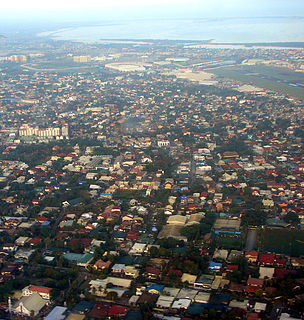
Bacoor[bakoʔˈoɾ], officially the City of Bacoor,, or simply known as Bacoor City, is a 1st class city in the province of Cavite, Philippines. According to the 2015 census, it has a population of 600,609 people.

When completed, the station will link directly to SM City Bacoor shopping mall. It will also be located near the terminal for buses and jeepneys bound for Cavite City, Kawit, Noveleta and Rosario via Tirona and Antero Soriano Highway. Other destinations include the Cavite Coliseum in Salinas, PAGCOR Club Bacoor, and the Cavite School of Saint Mark.

Cavite City Component City in Calabarzon, Philippines

Cavite City, officially the City of Cavite,, is a 4th class city in the province of Cavite, Philippines. According to the 2015 census, it has a population of 102,806 people.

Kawit, Cavite Municipality in Calabarzon, Philippines

Kawit, officially the Municipality of Kawit,, is a 1st class municipality in the province of Cavite, Philippines. According to the 2015 census, it has a population of 83,466 people.

Rosario, Cavite Municipality in Calabarzon, Philippines

Rosario, officially the Municipality of Rosario,, is a 1st class municipality in the province of Cavite, Philippines. According to the 2015 census, it has a population of 110,706 people.

Related Research Articles

Parañaque Highly Urbanized City in National Capital Region, Philippines

Parañaque, officially the City of Parañaque,, or simply known as Parañaque City, is a 1st class highly urbanized city in Metro Manila, Philippines. According to the 2015 census, it has a population of 665,822 people.

Manila–Cavite Expressway road in the Philippines

The Manila–Cavite Expressway, also known as Coastal Road or CAVITEx, is a 14-kilometre-long (8.7 mi) limited-access toll expressway linking Manila to the southern province of Cavite in the Philippines. The entire expressway is designated Expressway Route 3 (E3) of the Philippine expressway network and forms part of Radial Road 1 (R-1) of Manila's arterial road network. It is owned by the Public Estates Authority Tollway Corporation (PEATC), a government corporation and subsidiary of the Public Estates Authority, a government agency under the Office of the President, and is operated by Cavitex Infrastructure Corporation, a unit of Philippine-based company Metro Pacific Investments Corporation (MPIC).

Baclaran station station on the Manila LRT Yellow Line (LRT-1)

Baclaran LRT station is a station on the Manila Light Rail Transit System Line 1 or. The station is located on the last stretches of Taft Avenue in Pasay, right at the border with Baclaran, Parañaque, and, like all other stations on the LRT-1, Baclaran terminal is above-ground on viaduct. The terminal is named after the famous shopping district of the same name, which is located on the borders of the cities of Pasay and Parañaque.

Manila Light Rail Transit System Line 1 The first rapid transit line of Metro Manila.

The Manila Light Rail Transit System Line 1 is the first metro line of the Manila Light Rail Transit System. Presently, the line contains twenty stations and runs on 19.65 kilometers (12.21 mi) of fully elevated route. The line is colored yellow (old) and green (new) on all railway maps.

Zapote LRT station is a proposed stop on the Manila LRT. It is part of the LRT Line 1 South Extension Project. The station would be the first LRT station outside Metro Manila, being located in Bacoor in Cavite. The station will be located near the Zapote Exit Ramp of Manila-Cavite Expressway in Barangay Zapote V (Longos) in Bacoor.

Radial Road 2

Radial Road 2, more commonly referred to as R-2, is a network of roads and bridges that altogether form the second arterial road of Manila in the Philippines. The road runs north-south linking the City of Manila to the Metro Manila cities of Pasay, Parañaque and Las Piñas, down to Bacoor, Imus, Dasmariñas, Silang and Tagaytay in the province of Cavite.

Template:Infobox military person A traitor in the Philippine History. Plotted against Bonifacio.

Aguinaldo Highway major highway in Calabarzon, Philippines

The Emilio Aguinaldo Highway, also known as Cavite–Batangas Road and Manila West Road is a four-to-six lane, 41.4-kilometre (25.7 mi), network of primary and secondary highways passing through the busiest towns and cities of Cavite, Philippines. It is the busiest and most congested of the three major highways located in the province, the others are Governor's Drive and Antero Soriano Highway.

Niog station is an under construction station on the Line 1 and a proposed station on Line 6. The station will be located in the intersection of Aguinaldo Highway and Niog Street in Niog I, Bacoor in Cavite. It is part of the Line 1 South Extension Project, being the final station on the planned extension, while it shall be an intermodal terminal with the Line 6 towards Governor's Drive station

Alabang–Zapote Road road in the Philippines

Alabang–Zapote Road is a four-lane national road which travels east–west through the southern limits of Metro Manila, Philippines. It runs parallel to Dr. Santos Avenue in the north and is named for the two barangays that it links: Alabang in Muntinlupa and Zapote in Las Piñas.

The Daang Hari station is a proposed stop on the Manila Light Rail Transit System Line 6 in the Philippines. The station will be located in Anabu II, Imus, Cavite at the intersection of Aguinaldo Highway with Daang Hari Road and Open Canal Road. Like most planned stations, the station will be above ground. It will be the third stop on the Line 6 from Niog station and the third for trains heading north from the proposed southern terminus at Governor's Drive.

The Congressional Avenue station is a proposed stop on the Manila Light Rail Transit System Line 6 in the Philippines. The station will be located at the boundaries of Pasong Lawin and Barangay Zone IV in Dasmariñas, Cavite at the intersection of Aguinaldo Highway with Gov. Dominador Mangubat Avenue and Isidro Mangubat Street. Like most planned stations, the station will be above ground. It will be the fifth stop on the Line 6 from Niog station and the first for trains heading north from the proposed southern terminus at Governor's Drive.

The Governor's Drive station is a proposed station on the Manila Light Rail Transit System Line 6 in the Philippines. The station will be located in Paliparan, at the southern portion of the city of Dasmariñas, Cavite. The station is named after its proposed location at Governor's Drive where it intersects with Aguinaldo Highway. Like most stations of the planned stations, the station will be above ground. It will be the southern terminus on the Line 6.

The Salitran station is a proposed stop on the Manila Light Rail Transit System Line 6 in the Philippines. The station will be located in Salitran, at the northern portion of the city of Dasmariñas, Cavite, near the intersection of Aguinaldo Highway and Salitran Road. Like most stations of the planned stations, the station will be above ground. It will be the fourth stop on the Line 6 from Niog station and the second for trains heading north from its southern terminus at Governor's Drive.

Imus station is a proposed stop on the Manila Light Rail Transit System Line 6 in the Philippines. The station will be located at the boundaries of Bayang Luma and Tanzang Luma near the poblacion of Imus, Cavite. Like most planned stations, the station will be above ground. It will be the second stop on the Line 6 from Niog station and the fourth for trains heading north from its southern terminus at Governor's Drive.

The Emiliano Tria Tirona Memorial National High School is a secondary public high school located in Gahak, Kawit, Cavite in the Philippines.

The National Route 62 (N62) forms part of the Philippine highway network. It runs south from Metro Manila to northeastern Cavite.

References

  1. "LRT Line 6 gets 'conditional' OK from ICC-CABCOM". BusinessWorld . Retrieved 4 July 2015.