
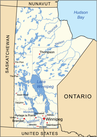
Lake Winnipeg is a very large, relatively shallow 24,514-square-kilometre (9,465 sq mi) lake in North America, in the province of Manitoba, Canada. Its southern end is about 55 kilometres (34 mi) north of the city of Winnipeg. Lake Winnipeg is Canada's sixth-largest freshwater lake and the third-largest freshwater lake contained entirely within Canada, but it is relatively shallow excluding a narrow 36 m (118 ft) deep channel between the northern and southern basins. It is the eleventh-largest freshwater lake on Earth. The lake's east side has pristine boreal forests and rivers that were in 2018 inscribed as Pimachiowin Aki, a UNESCO World Heritage Site. The lake is 416 km (258 mi) from north to south, with remote sandy beaches, large limestone cliffs, and many bat caves in some areas. Manitoba Hydro uses the lake as one of the largest reservoirs in the world. There are many islands, most of them undeveloped.
Lake Winnipegosis is a large (5,370 km2) lake in central North America, in Manitoba, Canada, some 300 km northwest of Winnipeg. It is Canada's eleventh-largest lake.

Lake of the Woods is a lake occupying parts of the Canadian provinces of Ontario and Manitoba and the U.S. state of Minnesota. Lake of the Woods is over 70 miles (110 km) long and wide, containing more than 14,552 islands and 65,000 miles (105,000 km) of shoreline. It is fed by the Rainy River, Shoal Lake, Kakagi Lake and other smaller rivers. The lake drains into the Winnipeg River and then into Lake Winnipeg. Ultimately, its outflow goes north through the Nelson River to Hudson Bay.

Lake Athabasca is in the north-west corner of Saskatchewan and the north-east corner of Alberta between 58° and 60° N in Canada. The lake is about 30% in Alberta and 70% in Saskatchewan.

The Qu'Appelle River is a river in the Canadian provinces of Saskatchewan and Manitoba that flows 430 kilometres (270 mi) east from Lake Diefenbaker in south-western Saskatchewan to join the Assiniboine River in Manitoba, just south of Lake of the Prairies, near the village of St. Lazare. It is in a region called the Prairie Pothole Region of North America, which extends throughout three Canadian provinces and five U.S. states. It is also within Palliser's Triangle and the Great Plains ecoregion.
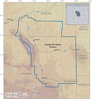
The Powder River Basin is a geologic structural basin in southeast Montana and northeast Wyoming, about 120 miles (190 km) east to west and 200 miles (320 km) north to south, known for its extensive coal reserves. The former hunting grounds of the Oglala Lakota, the area is very sparsely populated and is known for its rolling grasslands and semiarid climate.
Snow Lake is a town in Manitoba, Canada, located 685 km (426 mi) north of Winnipeg at the end of Provincial Road 392. The main industry is, and always has been, mining; currently with one mine producing Zinc, and another lithium. The official Town of Snow Lake is a very large, overwhelmingly rural area that is centered about the urban community of Snow Lake, which lies very near its geographical center. The Town is as large in area as a typical rural municipality in the more southern parts of Manitoba.

The Bendor Range is a small but once-famous subrange of the Pacific Ranges of the Coast Mountains, about It is approximately 7,000 square kilometres (2,700 sq mi) in area and about 40 km long and about 18 km at its widest. It lies between Anderson Lake on the southeast and the Carpenter Lake Reservoir or the Bridge River Power Project on the north, with the gold-rich valley of Cadwallader Creek on its southwest.

Whiteshell Provincial Park is a provincial park in southeast Manitoba, approximately 120 kilometres (75 mi) east of the city of Winnipeg. The park is considered to be a Class II protected area under the IUCN protected area management categories. It is 275,210 hectares in size.

Turtle Mountain, or the Turtle Mountains, is an area in central North America, in the north-central portion of the U.S. state of North Dakota and southwestern portion of the Canadian province of Manitoba, approximately 62 miles (100 km) south of the city of Brandon on Manitoba Highway 10 / U.S. Route 281. It is a plateau 2,000 ft above sea level, 300 ft to 400 ft above the surrounding countryside, extending 20 mi (32 km) from north to south and 40 mi (64 km) from east to west. Rising 1,031 feet (314 m), North Dakota's most prominent peak, Boundary Butte, is located at the western edge of the plateau.
The geography of Manitoba addresses the easternmost of the three prairie Canadian provinces, located in the longitudinal centre of Canada. Manitoba borders on Saskatchewan to the west, Ontario to the east, Nunavut to the north, and the American states of North Dakota and Minnesota to the south. Although the border with Saskatchewan appears straight on large-scale maps, it actually has many right-angle corners that give the appearance of a slanted line. In elevation, Manitoba ranges from sea level on Hudson Bay to 2727 ft (831 m) on top of Baldy Mountain. The northern sixty percent of the province is on the Canadian Shield. The northernmost regions of Manitoba lie permafrost, and a section of tundra bordering Hudson Bay.

Highway 5 is a major highway in the Canadian province of Saskatchewan. It begins in downtown Saskatoon and runs eastward to the Manitoba border near Togo, where it becomes Provincial Road 363. The highway is approximately 393 kilometres (244 mi) long. Between the early 1900s (decade) and 1976, Provincial Highway 5 was a trans-provincial highway travelling approximately 630 kilometres (390 mi) in length. At this time it started at the Alberta border in Lloydminster and traveled east to the Manitoba border.

Chaplin Lake is a salt lake in the south-west corner of the Canadian province of Saskatchewan. The lake is in the Prairie Pothole Region of North America, which extends throughout three Canadian provinces and five U.S. states, and within Palliser's Triangle and the Great Plains ecoregion of Canada. Along the northern shore is the village of Chaplin, Chaplin Nature Centre, and a sodium sulphate mine owned and operated by Saskatchewan Mining and Minerals. The lake is divided into four sections by dykes built by the mining company. The Trans-Canada Highway runs along the northern shore and Highway 58 runs through the middle of the lake in a south to north direction.

Bissett is a community situated on Rice Lake in the southeastern region of Manitoba, Canada, classified as a northern community and designated place. Located two and a half hours northeast of Winnipeg on Provincial Road 304, Bissett is an entry point to Nopiming Provincial Park.
The Bradshaw Mountains are a mountain range in central Arizona, United States, named for brothers Isaac and William D. Bradshaw after their deaths, having been formerly known in English as the Silver Mountain Range.

The Mines of Spain State Recreation Area and E. B. Lyons Nature Center is a state park in Dubuque County, Iowa, United States. It is near Dubuque, the eleventh-largest city in the state. The park features picnic areas, 15 miles (24 km) of walking/hiking trails, 4 miles (6.4 km) of ski trails, and the Betty Hauptli Bird and Butterfly Garden. It also includes archaeological sites of national importance as an early lead mining and smelting venture led by French explorer Julien Dubuque, as well as Dubuque's gravesite. These sites were collectively designated a National Historic Landmark District as Julien Dubuque's Mines.
Fine Gold Creek, in Fine Gold Gulch, is a creek in a gulch in Madera County, California that is a river tributary of the San Joaquin River. It is approximately 18 miles (29 km) from its mouth on the San Joaquin through where it has two forks to its headwaters.
Bernic Lake is a lake in the eastern part of the province of Manitoba, Canada. It is located just southwest of Nopiming Provincial Park, and just north of Whiteshell Provincial Park.

The Abitibi gold belt is a region of Canada that extends from Wawa, Ontario to Val-d'Or, Quebec. Located within the mineral-rich Abitibi greenstone belt, the gold belt is an established gold mining district having produced over 100 mines, and 170 million ounces of gold since 1901. Timmins, a town founded in 1912 following the Porcupine Gold Rush and subsequent creation of the Hollinger Mines, McIntyre Mines and Dome Mine, which was one area in the region that experienced a gold rush, beginning in 1909. The Kerr Addison Mine in Virginiatown was at one time Canada's largest gold producing mine. Many of the towns readily acknowledge gold mining as part of their history, some being named after gold. One of Canada's 'large roadside attractions' is a 12-foot replica of a 1908 gold sovereign built to commemorate Canada's first gold coin which was made using gold from the Kerr Addison owned Kerr-Addison mine.

Oak Lake is a lake in the southwestern region of the Canadian province of Manitoba.


