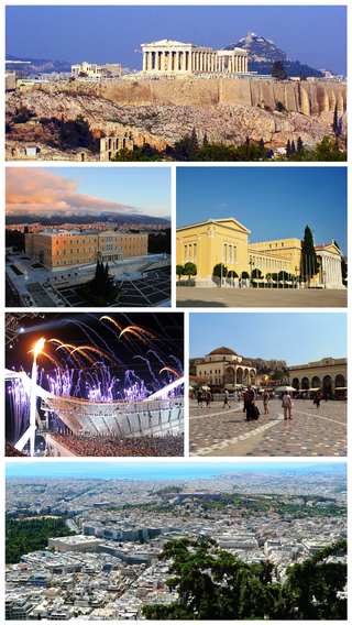
Athens is a major coastal urban area in the Mediterranean and it is both the capital and the largest city of Greece. With its urban area's population numbering over three million, it is also the eighth largest urban area in the European Union. Athens dominates and is the capital of the Attica region and is one of the world's oldest cities, with its recorded history spanning over 3,400 years, and its earliest human presence beginning somewhere between the 11th and 7th millennia BC. The city was named after a Greek war goddess.

England is a country that is part of the United Kingdom. It shares land borders with Wales to its west and Scotland to its north. The Irish Sea lies northwest and the Celtic Sea area of the Atlantic Ocean to the southwest. It is separated from continental Europe by the North Sea to the east and the English Channel to the south. The country covers five-eighths of the island of Great Britain, which lies in the North Atlantic, and includes over 100 smaller islands, such as the Isles of Scilly and the Isle of Wight.
The European Union (EU) is a supranational political and economic union of 27 member states that are located primarily in Europe. The union has a total area of 4,233,255 km2 (1,634,469 sq mi) and an estimated total population of nearly 447 million. The EU has often been described as a sui generis political entity combining the characteristics of both a federation and a confederation.

The euro is the official currency of 20 of the 27 member states of the European Union (EU). This group of states is known as the eurozone or, officially, the euro area, and includes about 344 million citizens as of 2023. The euro is divided into 100 cents.
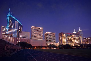
Houston is the most populous city in Texas and in the Southern United States. It is the fourth-most populous city in the United States after New York City, Los Angeles, and Chicago, and the sixth-most populous city in North America. With a population of 2,304,580 in 2020, Houston is located in Southeast Texas near Galveston Bay and the Gulf of Mexico; it is the seat and largest city of Harris County and the principal city of the Greater Houston metropolitan area, which is the fifth-most populous metropolitan statistical area in the United States and the second-most populous in Texas after Dallas–Fort Worth. Houston is the southeast anchor of the greater megaregion known as the Texas Triangle.

Mumbai is the capital city of the Indian state of Maharashtra. Mumbai is the de facto financial centre and the most populous city of India with an estimated city proper population of 12.5 million (1.25 crore). Mumbai is the centre of the Mumbai Metropolitan Region, the sixth most populous metropolitan area in the world with a population of over 23 million living under the Brihanmumbai Municipal Corporation. Mumbai lies on the Konkan coast on the west coast of India and has a deep natural harbour. In 2008, Mumbai was named an alpha world city.

Ohio is a state in the Midwestern United States. Of the fifty U.S. states, it is the 34th-largest by area. With a population of nearly 11.8 million, Ohio is the seventh-most populous and tenth-most densely populated state. Its capital and largest city is Columbus, with other large population centers including Cleveland, Cincinnati, Dayton, Akron, and Toledo. Ohio is bordered by Lake Erie to the north, Pennsylvania to the east, West Virginia to the southeast, Kentucky to the southwest, Indiana to the west, and Michigan to the northwest. Ohio is nicknamed the "Buckeye State" after its Ohio buckeye trees, and Ohioans are also known as "Buckeyes". Its state flag is the only non-rectangular flag of all the U.S. states.

Orkney, also known as the Orkney Islands, is an archipelago in the Northern Isles of Scotland, situated off the north coast of the island of Great Britain. Orkney is 10 miles (16 km) north of the coast of Caithness and has about 70 islands, of which 20 are inhabited. The largest island, the Mainland, has an area of 523 square kilometres (202 sq mi), making it the sixth-largest Scottish island and the tenth-largest island in the British Isles. Orkney's largest settlement, and also its administrative centre, is Kirkwall.

Vancouver is a major city in western Canada, located in the Lower Mainland region of British Columbia. As the most populous city in the province, the 2021 Canadian census recorded 662,248 people in the city, up from 631,486 in 2016. The Greater Vancouver area had a population of 2.6 million in 2021, making it the third-largest metropolitan area in Canada. Greater Vancouver, along with the Fraser Valley, comprises the Lower Mainland with a regional population of over 3 million. Vancouver has the highest population density in Canada, with over 5,700 people per square kilometre, and fourth highest in North America.

The West Bank is a landlocked territory near the coast of the Mediterranean in the Levant region of Western Asia that forms the main bulk of the Palestinian territories. It is bordered by Jordan and the Dead Sea to the east and by Israel to the south, west, and north. It has been under an Israeli military occupation since the 1967 Arab-Israeli War. Since the Oslo II Accord was signed in 1995, its area has been split into 165 Palestinian enclaves, that are under total or partial civil administration by the Palestinian National Authority (PNA), and a contiguous area containing 230 Israeli settlements into which Israeli law is "pipelined". The West Bank includes East Jerusalem. Israel administers the West Bank excluding East Jerusalem as the Judea and Samaria Area district, through the Israeli Civil Administration.

A tornado is a violently rotating column of air that is in contact with both the surface of the Earth and a cumulonimbus cloud or, in rare cases, the base of a cumulus cloud. It is often referred to as a twister, whirlwind or cyclone, although the word cyclone is used in meteorology to name a weather system with a low-pressure area in the center around which, from an observer looking down toward the surface of the Earth, winds blow counterclockwise in the Northern Hemisphere and clockwise in the Southern. Tornadoes come in many shapes and sizes, and they are often visible in the form of a condensation funnel originating from the base of a cumulonimbus cloud, with a cloud of rotating debris and dust beneath it. Most tornadoes have wind speeds less than 180 kilometers per hour, are about 80 meters across, and travel several kilometers before dissipating. The most extreme tornadoes can attain wind speeds of more than 480 kilometers per hour (300 mph), are more than 3 kilometers (2 mi) in diameter, and stay on the ground for more than 100 km (62 mi).
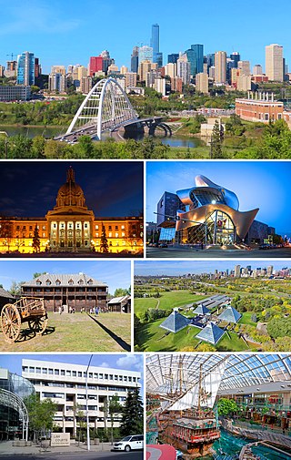
Edmonton is the capital city of the Canadian province of Alberta. Edmonton is situated on the North Saskatchewan River and is the centre of the Edmonton Metropolitan Region, which is surrounded by Alberta's central region. The city anchors the northern end of what Statistics Canada defines as the "Calgary–Edmonton Corridor," a region spanning between Edmonton and the city of Calgary, which includes the many smaller municipalities between the two.

Washington, D.C., formally the District of Columbia and commonly called Washington or D.C., is the capital city of the United States. The city is located on the east bank of the Potomac River, which forms its southwestern border with Virginia, and borders Maryland to its north and east. The city was named for George Washington, a Founding Father, commanding general of the Continental Army in the American Revolutionary War, and the first president of the United States, and the district is named for Columbia, the female personification of the nation.

Population density is a measurement of population per unit land area. It is mostly applied to humans, but sometimes to other living organisms too. It is a key geographical term. In simple terms, population density refers to the number of people living in an area per square kilometre, or other unit of land area.

In meteorology, precipitation is any product of the condensation of atmospheric water vapor that falls from clouds due to gravitational pull. The main forms of precipitation include drizzle, rain, sleet, snow, ice pellets, graupel and hail. Precipitation occurs when a portion of the atmosphere becomes saturated with water vapor, so that the water condenses and "precipitates" or falls. Thus, fog and mist are not precipitation but colloids, because the water vapor does not condense sufficiently to precipitate. Two processes, possibly acting together, can lead to air becoming saturated: cooling the air or adding water vapor to the air. Precipitation forms as smaller droplets coalesce via collision with other rain drops or ice crystals within a cloud. Short, intense periods of rain in scattered locations are called showers.

In meteorology, a low-pressure area, low area or low is a region where the atmospheric pressure is lower than that of surrounding locations. Low-pressure areas are commonly associated with inclement weather, while high-pressure areas are associated with lighter winds and clear skies. Winds circle anti-clockwise around lows in the northern hemisphere, and clockwise in the southern hemisphere, due to opposing Coriolis forces. Low-pressure systems form under areas of wind divergence that occur in the upper levels of the atmosphere (aloft). The formation process of a low-pressure area is known as cyclogenesis. In meteorology, atmospheric divergence aloft occurs in two kinds of places:

An urban area, built-up area or urban agglomeration is a human settlement with a high population-density and an infrastructure of built environment.

Rain is water droplets that have condensed from atmospheric water vapor and then fall under gravity. Rain is a major component of the water cycle and is responsible for depositing most of the fresh water on the Earth. It provides water for hydroelectric power plants, crop irrigation, and suitable conditions for many types of ecosystems.

The hectare is a non-SI metric unit of area equal to a square with 100-metre sides (1 hm2), or 10,000 m2, and is primarily used in the measurement of land. There are 100 hectares in one square kilometre. An acre is about 0.405 hectares and one hectare contains about 2.47 acres.


