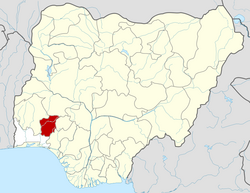
Ede North | |
---|---|
Coordinates: 7°44′N4°29′E / 7.733°N 4.483°E | |
Country | Nigeria |
State | Osun State |
Government | |
• Local Government Chairman and the Head of the Local Government Council | Daud Akinloye |
Area | |
• Total | 111 km2 (43 sq mi) |
Population (2006 census) | |
• Total | 83,831 |
Time zone | UTC+1 (WAT) |
3-digit postal code prefix | 232 |
ISO 3166 code | NG.OS.EN |
Ede North is a Local Government Area in Osun State, Nigeria. Its headquarters as Abere.
It has an area of 111 km2 and a population of 83,831 at the 2006 census.
The postal code of the area is 232. [1]
In Ede, the dry season is muggy and partially cloudy, and it is hot all year long. The wet season is oppressive and overcast. The average annual temperature ranges from 66 to 94 degrees Fahrenheit, rarely falling below 60 or rising over 99. [2] [3]
Between January 22 and April 3, which is the length of the hot season, the daily maximum temperature averages over 91°F. In Ede, March is the warmest month of the year, with an average high of 93°F and low of 73°F. [2] [4]
The cool season lasts for 3.8 months, from June 15 to October 7, with an average daily high temperature below 85°F. The coldest month of the year in Ede is August, with an average low of 70°F and high of 82°F. [5] [6] [7]
In Ede, the average percentage of the sky covered by clouds experiences significant seasonal variation over the course of the year. [8]
The clearer part of the year in Ede begins around November 18 and lasts for 2.9 months, ending around February 13. [9]
December is the clearest month of the year in Ede, with the sky remaining clear, mostly clear, or partly cloudy 51% of the time on average. [10]
Beginning about February 13 and lasting for 9.1 months, the cloudier period of the year ends with around November 18. [11]
April is the cloudiest month of the year in Ede, with the sky being overcast or mostly cloudy 85% of the time on average. [12] [13]
A day that has at least 0.04 inches of liquid or liquid-equivalent precipitation is considered to be wet. In Ede, the likelihood of rainy days fluctuates wildly throughout the year. [2]
From April 9 to October 26 (the length of the wetter season), there is a greater than 43% chance that any particular day will be rainy. In Ede, September has an average of 24.9 days with at least 0.04 inches of precipitation, making it the month with the most wet days. [4] [3]
From October 26 to April 9, or 5.5 months, is the dry season. With an average of 1.3 days with at least 0.04 inches of precipitation, December is the month with the fewest wet days in Ede. [1] [4]
We categorize rainy days into those that only involve rain, those that only involve snow, and those that combine the two. [4] [5] With an average of 24.9 days, September is the month in Ede with the most rainy days. According to this classification, rain alone has a high probability of 84% on September 12 and is the most frequent type of precipitation throughout the year. [4]
Yenagoa is a Local Government Area and capital city of Bayelsa State, Southern Nigeria. It is located at the Niger-Delta region of the country at coordinates 4°55′29″N6°15′51″E.
Ogoja is a Local Government Area in Cross River State, Nigeria. Its headquarters is Ogoja town in the northeast of the area near the A4 highway at 6°39′17″N8°47′51″E.
Bebeji is a Local Government Area in Kano State, Nigeria. Its headquarters are in the town of Bebeji.
Bende is a Local Government Area in Abia State, Nigeria with headquarters located in Bende Community. Bende Local Government Area (L.G.A) of Abia state lies on 70 30I of the Greenwich Meridian and latitude 50 30I North of the Equator. It is composed of thirteen (13) communities, namely: Alayi, Bende, Ezukwu, Igbere, Item, Itumbuzo, Nkpa, Ntalakwu, Ozuitem, Ugwueke, Umu-imenyi, Umuhu-Ezechi, and Uzuakoli.
Otan Ayegbaju is an historic town in Yorubaland founded about 800 years ago by descendants of Oduduwa, Olasooye Osilokun the 16th child of Oduduwa who migrated from Ifẹ. It is the headquarters of Boluwaduro Local Government Area. Nearby towns are Eripa, Iresi, Igbajo, Oke-irun and Oyan. It's the seat of the Catholic Diocese of Osogbo Marian pilgrimage.
Ankpa is a Local Government Area in Kogi State, Nigeria. Its headquarters are in the town of Ankpa on the A233 highway in the west of the area at7°22′14″N7°37′31″E.
Demsa is a Local Government Area of Adamawa State, Nigeria with headquarters located in Demsa. Demsa lies on the Benue River.
Ganye is a town and Local Government Area of Adamawa State, Nigeria. Jada and Toungo Local Governments were carved out from Ganye local government area of Adamawa state Nigeria. Ganye is bordered by Jada Local Government Area to the North and East, Toungo Local Government Area to the South and Taraba State to the West. It is the headquarter of the Sama (Chamba) people worldwide.
Mubi North is a Local Government Area of Adamawa State, Nigeria. The town is the location of the Adamawa State University and the Federal Polytechnic, Mubi.
Birnin Gwari is a Local Government Area in Kaduna State, Nigeria. Its headquarters are in the town of Birnin Gwari.
Zing is a Local Government Area in Taraba State, Nigeria. Its headquarters are in the town of Zing.
Mangu is a Local Government Area in Plateau State, Nigeria. Governor Caleb Mutfwang appointed Markus Artu as the Transition Committee Chairman of the LGA. Its headquarters are in the town of Mangu at 9°31′00″N9°06′00″E.
Ife South is a Local Government Area in Osun State, Nigeria. Its headquarters are in the town of Ifetedo at 7°11′00″N4°42′00″E.
Bwari is a local government area in the Federal Capital Territory in Nigeria. The original inhabitants of the town are the Gbagyi speaking people. The paramount ruler is the Esu who is otherwise known as Sa-bwaya. However, with the establishment of FCT in Abuja so many changes occurred; such changes include the turbaning of late Musa Ijakoro as District Head of Bwari in 1976, and his elevation as Sarki of Bwari to the position of a second class status in 1997 by the Ministry of the Federal Capital Territory under the then minister, General Jeremiah Useni.
Akwete town is the headquarters of Ukwa East local government area of Abia state, Nigeria. Akwete is located 18 Kilometers northeast of the oil-rich city of Port Harcourt and 18 Kilometers southeast of the commercial city of Aba. Akwete is an important community of the Ndoki and Igbo people in general, they belong to the Umuihueze II clan. Akwete is known in West Africa for its unique weaving.
Osu is a town in Osun State, Nigeria.
Okpuala Ngwa is a town in Isiala-Ngwa North. It serves as the administrative headquarters for the local government. It was the first settlement and headquarters of the Ngwa people. The people of Okpuala Ngwa speak the Ngwa dialect of the Ngwa people.
Iperindo town is situated in the Osun region. Osogbo (Osogbo), the capital of Osun, lies about 42 kilometers from Iperindo. Iperindo and Abuja, the capital of Nigeria, are separated by a distance of roughly 341 kilometers.
Apomu is a medium-sized town in the Osun state. It has a population of about 71,656 people.
Bode Osi is a town in Osun State, Nigeria. It is located around 36 kilometres (22 mi) away from Osogbo, the capital of Osun State, and 370 kilometres (230 mi) from Abuja, the capital of Nigeria. Bode Osi is also the headquarters of Ola Oluwa Local Government Area.