Boroughs and quarters of Berlin

Last updated
Boroughs and quarters of Berlin Berlin, administrative divisions (+districts +boroughs -pop) - de - colored.svg
Boroughs and quarters of Berlin

Berlin is divided into boroughs or administrative districts (Verwaltungsbezirke). In Berlin, the term is officially shortened to Bezirke (districts). The boroughs are further divided into quarters (Ortsteile). These smaller localities are officially recognised, but have no administrative bodies of their own. Quarters and many of their subunits, the neighborhoods (Ortslagen), typically have strong identities that sometimes predate their inclusion into the modern boundaries of Berlin. Both the boroughs and the quarters function differently to other subdivisions in Germany due to Berlin's dual status as an independent city (kreisfreie Stadt) as well as a federated state of Germany (Land) in its own right.

Contents

Since 2001, Berlin has been made up of twelve boroughs, each with its own administrative body. However, because Berlin is a single municipality (Einheitsgemeinde), its boroughs have limited power, acting only as agencies of Berlin's state and city governments as laid out in the Greater Berlin Act of 1920. The boroughs are financially dependent on state donations, as they neither possess any taxation power nor own any property. This is in contrast to municipalities and counties in other German states, which are territorial corporations (Gebietskörperschaften) with autonomous functions and property.

Each borough is administered by an assembly of borough representatives (Bezirksverordnetenversammlung), directly elected by proportional representation, and a district office (Bezirksamt) led by a borough mayor (Bezirksbürgermeister), elected by the borough representatives. The district office is in charge of most administrative matters affecting its borough's residents, but its decisions can be revoked by the Berlin Senate. The borough mayors form a council of mayors (Rat der Bürgermeister), led by the city's governing mayor, and the council advises the Berlin Senate.

    History

    Berlin boroughs (borders as of 1987) over the four occupation sectors of Berlin (1945-1990) West & East Berlin (1945-1990).png
    Berlin boroughs (borders as of 1987) over the four occupation sectors of Berlin (1945-1990)
    The 23 former boroughs of Berlin (1990-2000) Berliner Bezirke vor 2001.png
    The 23 former boroughs of Berlin (1990–2000)
    Residents without a migration background in Berlin on 31 December 2020 by district Einwohnerinnen und Einwohner ohne Migrationshintergrund in Berlin am 31. Dezember 2020 nach Bezirken.svg
    Residents without a migration background in Berlin on 31 December 2020 by district

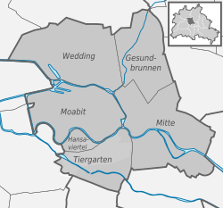
    Each borough is made up of several officially recognized smaller districts or quarters (Ortsteile). The number of quarters that form a borough varies considerably, ranging from two (Friedrichshain-Kreuzberg) to fifteen (Treptow-Köpenick). Most of Berlin's quarters are further composed of even smaller so-called Kieze (neighborhoods), officially called Ortslagen. The number of officially recognized neighborhoods in Berlin's quarters also varies greatly, ranging from two (Kreuzberg) to many more in older quarters, for example nine in Mitte, with many more inofficial neighborhoods and neighborships having formed over the decades. The quarters of Berlin and many of their neighborhoods typically have a historical identity as former independent cities, villages, or rural municipalities that were united in 1920 as part of the Greater Berlin Act, forming the basis for the present-day city and state. Berliners often identify more with the quarter where they live than with the borough that governs them, and in larger or older quarters, the smaller neighborhoods have often become the defining social spheres for their residents. The quarters do not have their own governmental bodies, but for urban planning and statistical purposes, the quarters are officially recognized and further subdivided into statistical zones and lebensweltlich orientierte Räume (lifeworld-oriented regions). These areas correspond roughly, but not exactly, with the official and inofficial social and historical neighborhoods recognized by residents.

    When Greater Berlin was established in 1920, the city was organized into twenty boroughs, most of which were named after their largest component quarter, often a former city or municipality; others, such as Kreuzberg and Prenzlauer Berg, were named for geographic features. Minor changes to borough boundaries were made in 1938. After World War II, Berlin was divided into four sectors, with the Western sectors controlled by the United States, Britain, and France, and the Eastern sector controlled by the Soviet Union.

    In 1961, the SED built the Berlin Wall to divide the city, effectively separating West Berlin from East Berlin and the rest of East Germany. Three new boroughs were created in East Berlin: Marzahn was split off from Lichtenberg in 1979, Hohenschönhausen from Weißensee in 1985, and Hellersdorf from Marzahn in 1986. In 1989, the Berlin Wall fell, and the city was reunified. This marked the end of the Cold War and the beginning of a new era in Berlin's history.

    After reunification, Berlin underwent a process of rapid transformation, as the city worked to rebuild and modernize its infrastructure and economy. Many new businesses and cultural institutions were established, and the city became a center of creativity and innovation.

    By 2000, Berlin comprised twenty-three boroughs, as three new boroughs had been created in East Berlin. Today Berlin is divided into twelve boroughs, reduced from twenty-three boroughs by Berlin's 2001 administrative reform.

    Boroughs

    An administrative reform in 2001 merged all but three of the existing boroughs into the current 12 boroughs, as listed below. [1] The three boroughs that were not affected were Spandau, Reinickendorf and Neukölln, as the population of each was already exceeding 200,000.

    Borough Bundestag constituency Population
    31 December 2023
    Area
    in km2
    Density
    per km2
    Map
    Charlottenburg-Wilmersdorf Berlin-Charlottenburg-Wilmersdorf
    (excluding Charlottenburg-Nord and the neighbourhood of Kalowswerder)
    343,08164.725,301 Berlin, administrative divisions (+districts -boroughs -pop) - de - colored.svg
    Friedrichshain-Kreuzberg Berlin-Friedrichshain-Kreuzberg – Prenzlauer Berg East 293,45420.1614,556
    Lichtenberg Berlin-Lichtenberg 311,88152.295,964
    Marzahn-Hellersdorf Berlin-Marzahn-Hellersdorf 291,94861.744,728
    Mitte Berlin-Mitte 397,13439.4710,062
    Neukölln Berlin-Neukölln 330,01744.937,345
    Pankow Berlin-Pankow
    (excluding Prenzlauer Berg east of Prenzlauer Allee)
    424,307103.014,119
    Reinickendorf Berlin-Reinickendorf 268,79289.463,005
    Spandau Berlin-Spandau – Charlottenburg North 257,09191.912,797
    Steglitz-Zehlendorf Berlin-Steglitz-Zehlendorf 310,446102.503,029
    Tempelhof-Schöneberg Berlin-Tempelhof-Schöneberg 355,86853.096,703
    Treptow-Köpenick Berlin-Treptow-Köpenick 294,081168.421,746

    Coats of arms

    The mural crown of the coats of arms of Berliner Bezirke Mural crown of the coat of arms of the Berlin boroughs.svg
    The mural crown of the coats of arms of Berliner Bezirke

    All coats of arms of Berlin's boroughs (the current as of the ones in the period 1990 to 2001) have some common attributes: the shield has a Spanish form, and the coronet is represented by a mural crown, three towers in red bricks with the Berlin's coat of arms in the middle.

    Most of the boroughs' current coats of arms [2] have changed some elements in their fields. Some display a fusion of themes of the merged Bezirke (Charlottenburg-Wilmersdorf, Lichtenberg, Steglitz-Zehlendorf, Tempelhof-Schöneberg); others have modified their themes taken from one of the two (or more) former merged boroughs (Friedrichshain-Kreuzberg, Marzahn-Hellersdorf, Mitte and Treptow-Köpenick). Only the unchanged boroughs of Neukölln, Reinickendorf and Spandau have not changed their fields. Pankow's coat of arms was created with a new design in 2008, having been the only borough without a coat of arms for seven years.

    Coat of arms of Charlottenburg-Wilmersdorf.svg
    Charlottenburg-Wilmersdorf
    Coat of arms of borough Friedrichshain-Kreuzberg.svg
    Friedrichshain-Kreuzberg
    Coat of arms of borough Lichtenberg.svg
    Lichtenberg
    Coat of arms of borough Marzahn-Hellersdorf.svg
    Marzahn-Hellersdorf
    Coat of arms of borough Mitte.svg
    Mitte
    Coat of arms of borough Neukoelln.svg
    Neukölln
    Coat of arms of borough Pankow.svg
    Pankow
    Coat of arms of borough Reinickendorf.svg
    Reinickendorf
    Coat of arms of borough Spandau.svg
    Spandau
    Coat of arms of borough Steglitz-Zehlendorf.svg
    Steglitz-Zehlendorf
    Coat of arms of borough Tempelhof-Schoeneberg.svg
    Tempelhof-Schöneberg
    Coat of arms of borough Treptow-Koepenick.svg
    Treptow-Köpenick

    Administration and politics

    The borough government is part of the two-tier administration of the Berlin city-state, whereby the Senate and its affiliated agencies, institutions, and municipal enterprises form the first tier of the so-called Hauptverwaltung (central administration). In the second tier, the boroughs enjoy a certain degree of autonomy, although in no way comparable to the German Landkreise districts or independent cities, nor even to the local government of a common municipality as a legal entity, as according to the Berlin Constitution the legal status of the city as a German state itself is that of a unified municipality (Einheitsgemeinde). The power of the borough governments is limited, and their performance of assigned tasks is subject to regulatory supervision by the Senate.

    Nevertheless, the twelve self-governing boroughs have constitutional status, and are themselves subdivided into two administrative bodies. Each is governed by the assembly of borough representatives (Bezirksverordnetenversammlung, BVV) and a full-time council at the borough's district office (Bezirksamt), consisting of five councilors (Bezirksstadträte) and headed by a borough mayor (Bezirksbürgermeister). The BVV is directly elected by the borough's population and therefore acts as a borough parliament, though it is officially part of the executive. It elects the members of the borough council, checks its daily administration, and is able to make applications and recommendations. The twelve borough mayors regularly meet in the Council of Mayors (Rat der Bürgermeister), led by the city's Governing Mayor; the council answers to and advises the Senate.

    The boroughs' quarters have no local government bodies, and the administrative duties of their former representatives, the Ortsvorsteher, were taken over by the borough mayors.

    State election party votes by constituency

    People who live in the former West Berlin tend to vote for the CDU and the SPD, While voters in the former East Berlin tend to vote for Linke and the AfD.

    Quarters

    As of 2012, the twelve boroughs are made up of a total of 97 officially recognized quarters (Ortsteile). Most of these smaller localities are further subdivided into officially recognized neighborhoods (Ortslagen), but often amalgamated or extended by the populace with other inofficial zones and areas, in German usually called Kieze, Stadtteile, Stadtviertel or Orte. The largest quarter (Ortsteil) is Köpenick (34.9 km2 or 13.5 sq mi), the smallest one is Hansaviertel (53 ha or 130 acres). The most populated quarter is Prenzlauer Berg (168,947 inhabitants in 2024), the least populated is Malchow (450 inhabitants in 2008). [3]

    Note that the coats of arms shown for quarters in the tables below are historical and no longer in official use, having lost their validity upon incorporation into Greater Berlin or new boroughs.

    (01) Mitte
    LocalityArea
    in km2
    Population
    as of 2008
    Density
    inhabitants per km2
    Map
    DEU Berlin-Mitte (district) COA.svg (0101) Mitte 10.7079,5827,445 Berlin Mitte.svg
    Sin escudo.svg (0102) Moabit 7.7269,4258,993
    Sin escudo.svg (0103) Hansaviertel 0.535,88911,111
    Coat of arms de-be tiergarten 1955.png (0104) Tiergarten 5.1712,4862,415
    DEU Wedding COA.svg (0105) Wedding 9.2376,3638,273
    Sin escudo.svg (0106) Gesundbrunnen                 6.1382,72913,496
    (02) Friedrichshain-Kreuzberg
    LocalityArea
    in km2
    Population
    as of 2008
    Density
    inhabitants per km2
    Map
    Coat of arms de-be friedrichshain 1991.png (0201) Friedrichshain                  9.78114,05011,662 Berlin Friedrichshain-Kreuzberg.svg
    DEU Kreuzberg (district) COA.svg (0202) Kreuzberg 10.40147,22714,184
    (03) Pankow
    LocalityArea
    in km2
    Population
    as of 2008
    Density
    inhabitants per km2
    Map
    DEU Prenzlauer Berg (Bezirk) COA.svg (0301) Prenzlauer Berg 11.00142,31912,991 Berlin Pankow.svg
    DEU Weissensee (district) COA.svg (0302) Weißensee 7.9345,4855,736
    Sin escudo.svg (0303) Blankenburg 6.036,5501,086
    Sin escudo.svg (0304) Heinersdorf 3.956,5801,666
    Sin escudo.svg (0305) Karow 6.6518,2582,746
    Sin escudo.svg (0306) Stadtrandsiedlung Malchow       5.681,166205
    Coat of arms de-be pankow 1987.png (0307) Pankow 5.6655,8549,868
    Sin escudo.svg (0308) Blankenfelde 13.401,917144
    Coat of arms de-be buch 1987.png (0309) Buch 18.2013,188727
    Coat of arms de-be buchholz 1987.png (0310) Französisch Buchholz 12.0018,7661,560
    Coat of arms de-be niederschoenhausen 1987.png (0311) Niederschönhausen 6.4926,9034,145
    Coat of arms de-be rosenthal 1987.png (0312) Rosenthal 4.908,9331,823
    Sin escudo.svg (0313) Wilhelmsruh 1.377,2165,267
    (04) Charlottenburg-Wilmersdorf
    LocalityArea
    in km2
    Population
    as of 2008
    Density
    inhabitants per km2
    Map
    DEU Charlottenburg (district) COA.svg (0401) Charlottenburg 10.60118,70411,198 Berlin Charlottenburg-Wilmersdorf.svg
    DEU Wilmersdorf (district) COA.svg (0402) Wilmersdorf 7.1692,81512,963
    Coats of arms of None.svg (0403) Schmargendorf 3.5919,7505,501
    Coats of arms of None.svg (0404) Grunewald 22.3010,014448
    Coats of arms of None.svg (0405) Westend 13.5037,8832,800
    Coats of arms of None.svg (0406) Charlottenburg-Nord             6.2017,3272,795
    Coats of arms of None.svg (0407) Halensee 1.2713,96610,997
    (05) Spandau
    LocalityArea
    in km2
    Population
    as of 2008
    Density
    inhabitants per km2
    Map
    Coats of arms of None.svg (0501) Spandau 8.0333,4334,164 Berlin Spandau.svg
    Coats of arms of None.svg (0502) Haselhorst 4.7313,6682,891
    Coats of arms of None.svg (0503) Siemensstadt 5.6611,3882,012
    Coats of arms of None.svg (0504) Staaken 10.9041,4703,810
    Coats of arms of None.svg (0505) Gatow 10.103,908386
    Coats of arms of None.svg (0506) Kladow 14.8013,628922
    Coats of arms of None.svg (0507) Hakenfelde 20.4026,3371,292
    Coats of arms of None.svg (0508) Falkenhagener Feld             6.8834,7785,056
    Coats of arms of None.svg (0509) Wilhelmstadt 10.4037,0803,558
    (06) Steglitz-Zehlendorf
    LocalityArea
    in km2
    Population
    as of 2008
    Density
    inhabitants per km2
    Map
    DEU District Steglitz COA.svg (0601) Steglitz 6.7970,55510,391 Berlin Steglitz-Zehlendorf.svg
    DEU Berlin-Lichterfelde COA.jpg (0602) Lichterfelde                    18.2078,3384,300
    Coa Germany Town Berlin-Lankwitz.svg (0603) Lankwitz 6.9940,3855,778
    Coat of arms de-be zehlendorf 1956.png (0604) Zehlendorf 18.8057,9023,075
    Coats of arms of None.svg (0605) Dahlem 8.3614,9661,784
    Coats of arms of None.svg (0606) Nikolassee 19.6115,899811
    Coats of arms of None.svg (0607) Wannsee 23.689,044382
    Coats of arms of None.svg (0608) Schlachtensee 4.0510,5732,611
    (07) Tempelhof-Schöneberg
    LocalityArea
    in km2
    Population
    as of 2008
    Density
    inhabitants per km2
    Map
    Coat of arms de-be schoeneberg 1956.png (0701) Schöneberg                    10.60116,74311,003 Berlin Tempelhof-Schoneberg.svg
    Coats of arms of None.svg (0702) Friedenau 1.6526,73616,204
    DEU District Tempelhof COA.svg (0703) Tempelhof 12.2054,3824,458
    Coats of arms of None.svg (0704) Mariendorf 9.3848,8825,211
    Coats of arms of None.svg (0705) Marienfelde 9.1530,1513,295
    Coats of arms of None.svg (0706) Lichtenrade 10.1049,4514,896
    (08) Neukölln
    LocalityArea
    in km2
    Population
    as of 2008
    Density
    inhabitants per km2
    Map
    Stadt-rixdorf.gif (0801) Neukölln 11.70154,12713,173 Berlin Neukolln.svg
    Coats of arms of None.svg (0802) Britz 12.4038,3343,091
    Coats of arms of None.svg (0803) Buckow 6.3538,0185,987
    Coats of arms of None.svg (0804) Rudow 11.8041,0403,478
    Coats of arms of None.svg (0805) Gropiusstadt                    2.6635,84413,475
    (09) Treptow-Köpenick
    LocalityArea
    in km2
    Population
    as of 2008
    Density
    inhabitants per km2
    Map
    Coat of arms de-be treptow 1992.png (0901) Alt-Treptow 2.3110,4264,513 Berlin Treptow-Kopenick.svg
    Coats of arms of None.svg (0902) Plänterwald 3.0110,6183,528
    Coats of arms of None.svg (0903) Baumschulenweg 4.8216,7803,481
    Coat of arms de-be johannisthal 1987.png (0904) Johannisthal 6.5417,6502,699
    Coats of arms of None.svg (0905) Niederschöneweide              3.4910,0432,878
    Coats of arms of None.svg (0906) Altglienicke 7.8926,1013,308
    Coats of arms of None.svg (0907) Adlershof 6.1115,1122,473
    Coats of arms of None.svg (0908) Bohnsdorf 6.5210,7511,649
    Coat of arms de-be oberschoeneweide 1987.png (0909) Oberschöneweide 6.1817,0942,766
    DEU Kopenick (district) COA.svg (0910) Köpenick 34.9059,2011,695
    Coat of arms de-be friedrichshagen 1987.png (0911) Friedrichshagen 14.0017,2851,233
    Coat of arms de-be rahnsdorf 1987.png (0912) Rahnsdorf 21.508,891414
    Coats of arms of None.svg (0913) Grünau 9.135,482600
    Wappen Muggelheim (Berlin).png (0914) Müggelheim 22.206,350286
    Coat of arms de-be schmoeckwitz 1987.png (0915) Schmöckwitz 17.104,117240
    (10) Marzahn-Hellersdorf
    LocalityArea
    in km2
    Population
    as of 2008
    Density
    inhabitants per km2
    Map
    Coat of arms de-be marzahn 1992.png (1001) Marzahn 19.50102,3985,240 Berlin Marzahn-Hellersdorf.svg
    Coats of arms of None.svg (1002) Biesdorf 12.4024,5431,973
    Coats of arms of None.svg (1003) Kaulsdorf 8.8118,7322,126
    Coat of arms de-be mahlsdorf 1987.png (1004) Mahlsdorf 12.9026,8522,075
    Coat of arms de-be hellersdorf 1992.png (1005) Hellersdorf                     8.1072,6028,963
    (11) Lichtenberg
    LocalityArea
    in km2
    Population
    as of 2008
    Density
    inhabitants per km2
    Map
    Coat of arms de-be friedrichsfelde 1987.png (1101) Friedrichsfelde 5.5550,0109,011 Berlin Lichtenberg.svg
    Coats of arms of None.svg (1102) Karlshorst 6.6021,3293,232
    Coat of arms de-be lichtenberg 1987.png (1103) Lichtenberg 7.2232,2954,473
    Coats of arms of None.svg (1104) Falkenberg 3.061,164380
    Coats of arms of None.svg (1106) Malchow 1.54450292
    Coats of arms of None.svg (1107) Wartenberg 6.922,433352
    Coats of arms of None.svg (1109) Neu-Hohenschönhausen          5.1653,69810,407
    Coat of arms de-be hohenschoenhausen.png (1110) Alt-Hohenschönhausen 9.3341,7804,478
    Coats of arms of None.svg (1111) Fennpfuhl 2.1230,93214,591
    Coats of arms of None.svg (1112) Rummelsburg 4.5217,5673,887
    (12) Reinickendorf
    LocalityArea
    in km2
    Population
    as of 2008
    Density
    inhabitants per km2
    Map
    Coats of arms of None.svg (1201) Reinickendorf 10.5072,8596,939 Berlin Reinickendorf.svg
    Coats of arms of None.svg (1202) Tegel 33.7033,417992
    Coats of arms of None.svg (1203) Konradshöhe 2.205,9972,726
    Coats of arms of None.svg (1204) Heiligensee 10.7017,6411,649
    Wappen-frohnau.jpg (1205) Frohnau 7.8017,0252,183
    WappenvoHermsdorf.jpg (1206) Hermsdorf 6.1016,5032,705
    Coats of arms of None.svg (1207) Waidmannslust 2.3010,0224,357
    Coats of arms of None.svg (1208) Lübars 5.004,915983
    Coat of arms de-be wittenau 1905.svg (1209) Wittenau 5.8722,6963,866
    Coats of arms of None.svg (1210) Märkisches Viertel               3.2035,20611,002
    Coat of arms de-be Borsigwalde.jpg (1211) Borsigwalde               2.036,4323,168

    See also

    References