Botley, Hampshire

Last updated

Botley
Village
South side of High Street, Botley - geograph.org.uk - 212646.jpg
Botley High Street
Hampshire UK location map.svg
Red pog.svg
Botley
Location within Hampshire
Population5,100 (2011 Census including Long Common)
OS grid reference SU520128
District
Shire county
Region
Country England
Sovereign state United Kingdom
Post town SOUTHAMPTON
Postcode district SO30
Dialling code 01489
Police Hampshire and Isle of Wight
Fire Hampshire and Isle of Wight
Ambulance South Central
UK Parliament
Website http://www.botley.com/
List of places
UK
England
Hampshire
50°54′52″N1°16′12″W / 50.914358°N 1.269994°W / 50.914358; -1.269994

Botley is a historic village in Hampshire, England. [1] It was developed as a natural crossing point for the River Hamble, and received its first market charter from Henry III in 1267. The village grew on the success of its mills, its coaching inns, and more recently strawberries, and was described as "the most delightful village in the world" by 18th century journalist and radical politician William Cobbett.

Contents

History

When the Romans built a road from Noviomagus Reginorum (Chichester) to Clausentum (Southampton), it crossed the River Hamble at a natural crossing point located to the south of present-day Botley. The crossing later became the site of Botley's first settlement, which existed at least as far back as the 10th century. Known in Saxon times as "Bottaleah" ("Botta" was probably a person, while "Leah" was the Saxon word for a woodland clearing). Some time prior to the Norman conquest, a gradual rise in sea level meant that travellers found the river easier to ford further north of the original Roman crossing, this new crossing place provided a new focal point for the village, which in 1086 was listed in the Domesday book as "Botelie" and included two water-powered mills and had a population of less than 100. [2] [3]

At that time, the mills were owned by the family of Ralph de Mortimer, a French nobleman who fought at the Battle of Hastings in 1066, and remained in the family's possession until 1304 when the manor, including the mills, passed to the order of St Elizabeth of Hungary in Winchester. [4] During the dissolution of the monasteries (1536-1539), the manor and mills were given to Thomas Wriothesly, a commissioner of Henry VIII and later Earl of Southampton. After the third Earl died without a male heir, the manor and mills passed to the Dukes of Portland. [4] From 1838 to 1921, the site was owned by W and J Clarke. As well as grinding and trading cereals, the company traded in coal and, for a short time, manufactured paper. [4] The Botley Flour Milling Company was formed in 1921, and in 1928 it was sold to the current owners, the Appleby family. [4]

In 1267 John of Botley, Lord of the Manor, obtained a royal charter from Henry III for holding an annual fair and weekly market in the town. The village did not, however, grow significantly and in 1665 the village still had a population of only 350. [5]

During the 18th century, Botley functioned as a small inland port with barges transporting coal, grain, timber and flour along the river. The first bridge over the tidal part of the river was built in 1797 and by the time of the 1801 census 614 people were residing in the village.

During the first half of the 19th century, the radical journalist and political reformer William Cobbett lived in Botley and called it "the most delightful village in the world". From 1805, [6] Cobbett lived initially at Botley House near Botley Mills, and then, from 1812, in a smaller house at Botley Hill. [6] [7]

A corn market was opened in 1829 and a cattle market in 1836, while Botley Market Hall – today a Grade II listed building – was built in 1848. A new church, All Saints, was built nearer the village centre in 1836. The National School opened in 1855 and the Recreation Ground was purchased in 1888. In the mid-nineteenth century the climate made south Hampshire ideal for growing strawberries and Botley became the centre for a thriving trade in strawberries. In 1841 Botley railway station was opened by the London and Southampton Railway Company. It became a major loading point for the seasonal strawberry traffic, as Botley formed the start of what is now known as the Strawberry Trail. [8]

Places of worship

Botley has had a place of worship since at least the 11th century.

St Bartholomew's Church, Botley StBartsBotley.jpg
St Bartholomew's Church, Botley

The early church, commonly called St Bartholomew's, adjacent to the old village of Boteleigh, was mentioned in the Domesday Book of 1086. This church, 1 mile (1.6 km) south of the current village, was largely destroyed after a large poplar tree fell onto the nave in the early 1830s. This reduced the original capacity of 500 to what had been the chancel. The existing structure is 13th-century with an older doorway retrieved from the ruins and reset in the west wall. The east window is Perpendicular Gothic in style and dates from the 15th century. The church was formally declared redundant in May 1982. [9] [10] [11] [12] [13]

A 'Dissenters Church' was built in Winchester Street in 1800, attracting a growing congregation.

All Saints

Following the partial destruction of St Bartholomew's, a replacement church, dedicated to All Saints, was constructed between 1835 and 1836. The new church was closer to the centre of the village; parishioners were finding it increasingly troublesome to take the path across the fields to the old church. The yellow-brick Gothic Revival church, designed by James William Wild, [14] was consecrated on 22 August 1836. The church's font dates to around the 12th century; [9] possibly from St Bartholomew's, it was recovered from a field in 1740. [9]

The church was expanded in 1859, [14] and architect Thomas Graham Jackson designed further expansions in 1892 and 1895. [9] [10] [14] A church room was built in 1967, and a two-storey extension was completed in 2008. [9]

Twin towns

Botley is twinned with:

Related Research Articles

<span class="mw-page-title-main">River Hamble</span> River in south Hampshire, England

The River Hamble in south Hampshire, England, rises near Bishop's Waltham and flows for 10.1 km (6.3 mi) through Botley, Bursledon, and Lower Swanwick before entering Southampton Water between Hamble Common and Warsash.

<span class="mw-page-title-main">Wickham, Hampshire</span> Village in Hampshire, England

Wickham is a village in the civil parish of Wickham and Knowle, in the Winchester district, in the county of Hampshire, England. It is about 3 miles north of Fareham. In 2021 it had a population of 2173. At the 2001 census, it the parish a population of 4,816, falling to 4,299 at the 2011 Census.

<span class="mw-page-title-main">Bishop's Waltham</span> Town in Hampshire, England

Bishop's Waltham is a medieval market town situated at the source of the River Hamble in Hampshire, England. It has a foot in the South Downs National Park and is located at the midpoint of a long-established route between Winchester and Portsmouth. It is home to the ruins of Bishop's Waltham Palace, a Scheduled Ancient Monument under English Heritage management, and a well-preserved high street with many listed buildings which now house independent shops.

<span class="mw-page-title-main">Borough of Eastleigh</span> Non-metropolitan borough and borough in England

The Borough of Eastleigh is a local government district with borough status in Hampshire, England. It is named after its main town of Eastleigh, where the council is based. The borough also contains the town of Hedge End along with several villages, many of which form part of the South Hampshire urban area.

<span class="mw-page-title-main">Hamble-le-Rice</span> Village in England

Hamble-le-Rice, commonly known as Hamble, is a village and civil parish in the Borough of Eastleigh in Hampshire, England. It is best known for being a flying training centre during the Second World War and is a popular yachting location. The village and the River Hamble also featured in the 1980s BBC television series Howards' Way. The village centre, known as The Square, Hamble, has a more traditional English village aesthetic which differentiates it from the small industrial areas close to the village.

<span class="mw-page-title-main">Hedge End</span> Human settlement in England

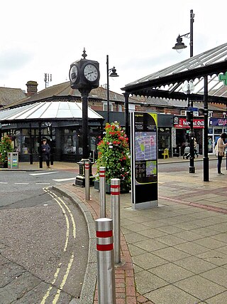
Hedge End is a town and civil parish in Hampshire, England. Situated to the east of the City of Southampton, it adjoins the districts of West End and Botley. Hedge End lies within the Borough of Eastleigh and is part of the Southampton Urban Area. The original hamlet developed on Botley Common after 1250 when it was granted to the men of Botley as common pasture. In 1267, royal charters allowed Botley to hold an annual fair and a weekly market on the common which eventually became a market town.

<span class="mw-page-title-main">West Coastway line</span> Railway line in England

The West Coastway line is a railway line in England linking the conurbations of Brighton/Hove/Littlehampton and Southampton/Portsmouth, with 1.3 million people between them. It has short southward branches to Littlehampton and Bognor Regis, which offer direct services to and from London.

<span class="mw-page-title-main">Bursledon</span> Human settlement in England

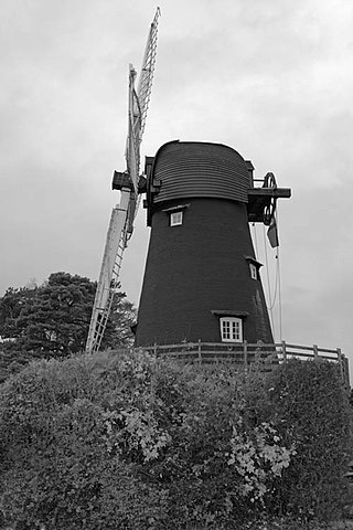
Bursledon is a village on the River Hamble in Hampshire, England. It is located within the borough of Eastleigh. Close to the city of Southampton, Bursledon has a railway station, a marina, dockyards and the Bursledon Windmill. Nearby villages include Swanwick, Hamble-le-Rice, Netley and Sarisbury Green.

<span class="mw-page-title-main">Warsash</span> Village in southern Hampshire, England

Warsash is a village in southern Hampshire, England, situated at the mouth of the River Hamble, west of the area known as Locks Heath and south of Sarisbury. Boating plays an important part in the village's economy, and the village has a sailing club. It is also home to the Warsash Maritime Academy, part of Southampton Solent University, which provides training for Merchant Navy Officers from around the world.

<span class="mw-page-title-main">Eastleigh (UK Parliament constituency)</span> Parliamentary constituency in the United Kingdom, 1955 onwards

Eastleigh is a constituency represented in the House of Commons of the UK Parliament since 2024 by Liz Jarvis, a Liberal Democrat.

<span class="mw-page-title-main">Bitterne</span> Suburb in England

Bitterne is an eastern suburb and ward of Southampton, in the ceremonial county of Hampshire, England.

<span class="mw-page-title-main">North Baddesley</span> Human settlement in England

North Baddesley is a large village and civil parish in Hampshire, England. It is situated 3 mi (5 km) east of the town of Romsey and 6 mi (10 km) north of Southampton. It occupies an area of approximately 9.15 km2 (3.53 sq mi), and is home to a population of just over 10,000 people, reducing to 7,000 at the 2011 Census. It is located in the Test Valley; a river famous for trout fishing.

<span class="mw-page-title-main">Bursledon Windmill</span> Historic windmill in England

Bursledon Windmill is a Grade II* listed windmill in Bursledon, Hampshire, England which has been restored to working order.

The Southampton–Fareham line is a railway line in England, along the south coast of Hampshire. As a through line it came late in British Railway history, traversing unpromising coastal terrain. The first part from Portswood, near Southampton, to Netley was opened in 1866, prompted by the establishment of the Royal Victoria Hospital at Netley, which had been established for the care of wounded soldiers.

<span class="mw-page-title-main">Curdridge</span> Human settlement in England

Curdridge is a village and civil parish within the City of Winchester district of Hampshire, England. The parish also contains the similarly named village of Curbridge. The village has a small school. The parish is located eight miles to the east of Southampton and had a population of 1,292 people in 473 households in the 2001 census, the population increasing to 1,398 in 520 households at the 2011 Census. Curdridge is also known for its annual Curdridge Country Show that takes place in a field off Reading Room Lane

<span class="mw-page-title-main">River Hamble Country Park</span> Country Park in Hampshire, England

River Hamble Country Park is a 144.1-hectare (356-acre) country park which runs along the west bank of the River Hamble between the villages of Botley and Bursledon in Hampshire. It is owned by Hampshire County Council and managed by Hampshire Countryside Service.

<span class="mw-page-title-main">Peartree Green</span> Human settlement in England

Peartree Green is an open space on high ground on the east bank of the River Itchen in Southampton. A 16/17th century building, Peartree House, still stands, though is today concealed by private housing. The house and the green take their name from a pear tree that grew near the parish church. Some of the original open space has been built on, but a large proportion remains as a recreational area. It contains a church and the remains of a boarding school. It overlooks the River Itchen to St Mary's Church in Southampton.

<span class="mw-page-title-main">South Stoneham</span> Human settlement in England

South Stoneham was a manor in South Stoneham parish. It was also a hundred, Poor law union, sanitary district then rural district covering a larger area of south Hampshire, England close to Southampton. In 1911 the parish had a population of 1934.

<span class="mw-page-title-main">All Saints, Botley</span> Church in Hampshire, United Kingdom

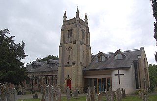
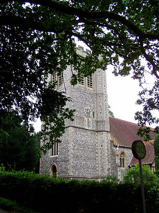
All Saints, Botley is an Anglican church in the centre of the village of Botley, Hampshire in southern England. Built in the 1830s to replace a church, St Bartholomew's, south of the village, it was expanded in 1859 and the 1890s. Further expansion followed in 1967 and in the early 2000s. Described as "an uninteresting specimen of its time", it is a Grade II* listed building.

References

  1. "Visit Hampshire | Discover the City, Coast and Country".
  2. http://www.eastleigh.gov.uk/PDF/04AreaProfiles-ParishesInEastleighBorough-Botley-20120530.pdf%5B%5D
  3. "A HISTORY OF BOTLEY - Local Histories". 14 March 2021.
  4. 1 2 3 4 "Our Heritage". Botley Mills. Retrieved 11 July 2024.
  5. "Things to see and do in Botley - Places - Hampshire". Archived from the original on 24 September 2015. Retrieved 6 June 2015.
  6. 1 2 Almroth-Wright, Indy (2 March 2009). "William Cobbett". BBC Hamphire & Isle of Wight. BBC. Retrieved 15 July 2024.
  7. "Botley House". Hampshire Gardens Trust. Retrieved 15 July 2024.
  8. "Botley - The Strawberry Trail".
  9. 1 2 3 4 5 O’Brien, Charles; Bailey, Bruce; Pevsner, Nikolaus; Lloyd, David W. (2018). The Buildings of England Hampshire: South. Yale University Press. pp. 120–122. ISBN   9780300225037.
  10. 1 2 Page, William (1908). "A History of the County of Hampshire: Volume 3. Parishes: Botley". Victoria County History of Hampshire. British History Online. pp. 465–467. Retrieved 5 August 2019.
  11. Historic England. "(Old) Church of St Bartholomew, Church Lane, Botley, Borough of Eastleigh (Grade II) (1322638)". National Heritage List for England . Retrieved 5 August 2019.
  12. Lloyd, David W. (1974). Buildings of Portsmouth and its Environs: A survey of the dockyard, defences, homes, churches, commercial, civic and public buildings. Portsmouth: City of Portsmouth. ISBN   0-901559-53-9., pp.19, 31, 125, 132.
  13. "The Church of England Statistics & Information: Lists (by diocese) of closed church buildings as at February 2011. Diocese of Portsmouth" (PDF). Church of England. 21 February 2011. Archived from the original (PDF) on 10 May 2012. Retrieved 1 June 2020.
  14. 1 2 3 Historic England. "Church of All Saints, High Street (south side), Botley, Borough of Eastleigh (Grade II*) (1322707)". National Heritage List for England . Retrieved 5 August 2019.
  15. 1 2 3 "British towns twinned with French towns". Archant Community Media Ltd. Archived from the original on 5 July 2013. Retrieved 11 July 2013.