Parramatta is a major suburb in the City of Parramatta and commercial district in Greater Western Sydney, located approximately 24 kilometres (15 mi) west of the Sydney CBD, on the banks of the Parramatta River. It is currently regarded as the secondary central business district in metropolitan Sydney, but it is moving ahead towards becoming a global city and a significant city in Australia in its own right by 2050.

Dubbo is a city in the Orana Region of New South Wales, Australia. It is the largest population centre in the Orana region, with a population of 43,516 at June 2021.
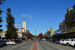
Goulburn is a regional city in the Southern Tablelands of New South Wales, Australia, approximately 195 kilometres (121 mi) south-west of Sydney and 90 kilometres (56 mi) north-east of Canberra. It was proclaimed as Australia's first inland city through letters patent by Queen Victoria in 1863. Goulburn had a population of 24,565 as of the 2021 census. Goulburn is the seat of Goulburn Mulwaree Council.

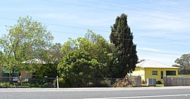
Lithgow is a town in the Central Tablelands of New South Wales, Australia and is the administrative centre of the City of Lithgow local government area. It is located in a mountain valley named Lithgow's Valley by John Oxley in honour of William Lithgow, the first Auditor-General of New South Wales.

Burwood is a suburb in the Inner West of Sydney, in the state of New South Wales, Australia. It is 10 kilometres (6.2 mi) west of the Sydney central business district and is the administrative centre for the local government area of Municipality of Burwood.

The City of Blue Mountains is a local government area of New South Wales, Australia, governed by the Blue Mountains City Council. The city is located in the Blue Mountains, on the Great Dividing Range at the far western fringe of the Greater Sydney area. Major settlements include, Katoomba, Lawson, Springwood and Blaxland.

The City of Penrith is a local government area in the state of New South Wales, Australia. The seat of the city is located in Penrith, located within Sydney about 50 kilometres (31 mi) west of Sydney central business district. It occupies part of the traditional lands of the Darug people. First incorporated as a municipality on 12 May 1871, on 1 January 1949, the municipalities of Penrith, St Marys and Castlereagh and part of the Nepean Shire amalgamated to form a new Municipality of Penrith. Penrith was declared a City on 21 October 1959, and expanded westwards to include Emu Plains and Emu Heights, formerly part of the City of Blue Mountains, on 25 October 1963. As of the 2021 census the City of Penrith had an estimated population of 217,664.

Rhema FM is the name used for a number of Christian radio stations established with the help of, and assisted for many years by United Christian Broadcasters (UCB) in Australia. Each station is independent, being run and programmed locally with many having moved away from the Rhema name. UCB has also established the Vision Radio Network across Australia, which is entirely networked from UCB's Brisbane studios.

Wollondilly Shire is a periurban local government area, located on the south west fringe of the Greater Sydney area in New South Wales, Australia, parts of which fall into the Macarthur, Blue Mountains and Central Tablelands regions in the state of New South Wales, Australia. Wollondilly is seen as the transition between Regional NSW and the Greater Sydney Region, and is variously categorised as part of both. Wollondilly Shire was created by proclamation in the NSW Government Gazette on 7 March 1906, following the passing of the Local Government (Shires) Act 1905, and amalgamated with the Municipality of Picton on 1 May 1940.

Uralla Shire is a local government area located in the New England region of New South Wales, Australia. The New England Highway passes through the Shire.

Wangi Power Station is a heritage-listed former coal-fired power station at Wangi Wangi, City of Lake Macquarie, New South Wales on Lake Macquarie. The power station operated between 1956 and 1986 and supplied electricity to New South Wales. It was once the largest in the state. The 12,000-square-metre (130,000 sq ft) building was listed on the New South Wales State Heritage Register on 2 April 1999.

No. 208 Radar Station RAAF is a heritage-listed former Royal Australian Air Force (RAAF) radar station at Mine Camp at Catherine Hill Bay and Pinny Beach, both in City of Lake Macquarie, New South Wales, Australia. It was established on 10 February 1943. The remains of the radar station were added to the New South Wales State Heritage Register on 22 July 2008.

Colonel Walter Liberty Vernon was an English architect who migrated to Australia and pursued his career as an architect in Sydney, New South Wales. In his role as the New South Wales Government Architect he is noted for designing multiple government buildings, many of which are extant with listings on national and state heritage registers.
This is a list of radio stations that broadcast on FM frequency 87.8 MHz:
The Bemboka River, a perennial stream of the Bega River catchment, is located in the Monaro and South Coast regions of New South Wales, Australia.
Whittingham railway station was a railway station on the Main North railway line, serving the locality of Whittingham in the Hunter Region, New South Wales.
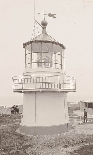
Nobbys Head Light is an active lighthouse on Nobbys Head, a headland on the south side of the entrance to Newcastle Harbour, New South Wales, Australia. An image of the lighthouse is included in the coat of arms of the City of Newcastle.

Murrumbidgee Council is a local government area in the Riverina region of New South Wales, Australia. This area was formed in 2016 from the merger of the Murrumbidgee Shire and the Jerilderie Shire.