
Middlesex County is located in the Commonwealth of Massachusetts, in the United States. As of the 2020 census, the population was 1,632,002, making it the most populous county in both Massachusetts and New England and the 22nd most populous county in the United States. Middlesex County is one of two U.S. counties to be amongst the top 25 counties with the highest household income and the 25 most populated counties. It is included in the Census Bureau's Boston–Cambridge–Newton, MA–NH Metropolitan Statistical Area. As part of the 2020 United States census, the Commonwealth's mean center of population for that year was geo-centered in Middlesex County, in the town of Natick.

Ashland is a town in Middlesex County, Massachusetts, United States. It is part of the MetroWest region. The population was 18,832 at the 2020 United States census.
Holliston is a New England town in Middlesex County, Massachusetts, United States in the Greater Boston area. The population was 14,996 at the 2020 census. It is located in MetroWest, a Massachusetts region that is west of Boston. Holliston is the only town in Middlesex County that borders both Norfolk and Worcester counties.
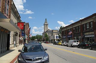
Marlborough is a city in Middlesex County, Massachusetts, United States. The population was 41,793 at the 2020 census. Marlborough became a prosperous industrial town in the 19th century and made the transition to high technology industry in the late 20th century after the construction of the Massachusetts Turnpike.

Medway is a town in Norfolk County, Massachusetts, United States. The town had a population of 13,115 at the 2020 census.

Millis is a town in Norfolk County in the U.S. state of Massachusetts. It had a population of 8,460 at the 2020 census. The town is approximately 19 miles (31 km) southwest of downtown Boston and is bordered by Norfolk, Sherborn, Holliston, Medfield, and Medway. Massachusetts state routes 109 and 115 run through Millis.

Boston and Worcester Electric Companies (B&W) was a holding company for several streetcar companies between Boston and Worcester, Massachusetts. The main line, built by the Boston and Worcester Street Railway, was an interurban streetcar line partly on the old Boston and Worcester Turnpike and partly on private right-of-way. Long after the line was converted to buses, Boston and Worcester Lines took over operations, and sold the franchises to various other bus companies.

The New York and New England Railroad (NY&NE) was a railroad connecting southern New York State with Hartford, Connecticut; Providence, Rhode Island; and Boston, Massachusetts. It operated under that name from 1873 to 1893. Prior to 1873 it was known as the Boston, Hartford and Erie Railroad, which had been formed from several smaller railroads that dated back to 1846. After a bankruptcy in 1893, the NY&NE was reorganized and briefly operated as the New England Railroad before being leased to the competing New York, New Haven and Hartford Railroad in 1898.

William Claflin was an American politician, industrialist and philanthropist from Massachusetts. He served as the 27th Governor of the Commonwealth of Massachusetts from 1869 to 1872 and as a member of the United States Congress from 1877 to 1881. He also served as chairman of the Republican National Committee from 1868 to 1872, serving as a moderating force between the Radical and moderate wings of the Republican Party. His name is given to Claflin University in South Carolina, a historically black college founded with funding from him and his father.

Massachusetts's 11th congressional district is an obsolete congressional district in eastern Massachusetts. It was eliminated in 1993 after the 1990 U.S. census. Its last congressman was Brian Donnelly; its most notable were John Quincy Adams following his term as president, eventual president John F. Kennedy and Speaker of the House Tip O'Neill.
Norfolk station is an MBTA Commuter Rail station in Norfolk, Massachusetts, served by the Franklin Line. The station has one platform which serves a single track, with a mini-high section for accessibility. The Norfolk County Railroad opened through the North Wrentham village of Wrentham in 1849. A branch line to Medway was open from 1852 to 1864. The station was renamed Norfolk along with the town in 1870. Several different railroads operated the line, with the New York, New Haven and Hartford Railroad running it for much of the 20th century. Massachusetts Bay Transportation Authority (MBTA) subsidies began in 1966, and the agency bought the line in 1973. The mini-high platform was added in 1990.

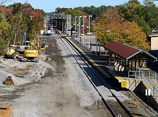
Framingham station is a historic Boston and Albany Railroad station located in downtown Framingham, Massachusetts. Designed by noted American architect H. H. Richardson, it was one of the last of the railroad stations he designed in the northeastern United States to be built. The station, built in 1884–85, served as a major stop on the B&A Main Line as well as a hub for branch lines to Milford, Mansfield, Fitchburg, and Lowell. After years of deterioration, the station was listed on the National Register of Historic Places in 1975 as the Framingham Railroad Station, and restored a decade later.

Carolyn (Coyne) Dykema was the Massachusetts state representative from the Massachusetts House of Representatives' 8th Middlesex district from 2009 until her resignation to take a private sector job in 2022.

Milford pink granite, also known as Milford granite or Milford pink is a Proterozoic igneous rock located in and around the town of Milford, Massachusetts, covering an area of approximately 39 square miles (100 km2), as mapped by the USGS. It is also sometimes referred to as Braggville granite, for several quarries in the neighboring village of Braggville, Massachusetts.

Pepperell is a town in Middlesex County, Massachusetts, United States. The population was 11,604 at the 2020 census. It includes the village of East Pepperell. Pepperell is home to the Pepperell Center Historic District, a covered bridge, and the 1901 Lawrence Library. The library has a collection of Sidney M. Shattuck’s (1876–1917) stuffed birds.

Bellingham is a town in Norfolk County, Massachusetts, United States. The population was 16,945 at the 2020 census. The town sits on the southwestern fringe of Metropolitan Boston, along the rapidly growing "outer belt" that is Interstate 495. It is formally a part of the Boston–Cambridge–Quincy metropolitan statistical area, as well as the Providence metropolitan area.
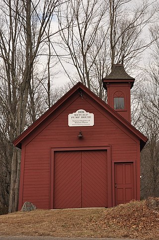
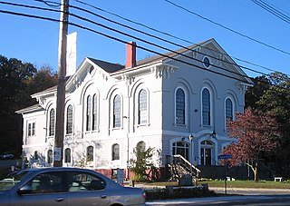
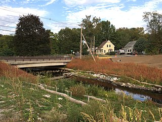
Metcalf is an unincorporated village and former railway stop located in the town of Holliston in Middlesex County, Massachusetts, United States. The village does not have its own post office, and was formerly a stop for the Boston and Albany Railroad. Today it is characterized its historic pump house and several historic structures abutting the crossroads of Washington St. and Summer St.. Historically the village also had a schoolhouse and several small farms, but remains a residential community today with some light industry, and the local Fatima Shrine.
Caryville is a former mill village located in the northeast corner of Bellingham, Massachusetts, U.S. spanning into the neighboring town of Franklin in the western part of Norfolk County.

Massachusetts House of Representatives' 10th Worcester district in the United States is one of 160 legislative districts included in the lower house of the Massachusetts General Court. It covers parts of Norfolk County and Worcester County. Democrat Brian Murray of Milford has represented the district since 2017.

The Medway Branch was a railway line in Norfolk County, Massachusetts. It was built by the Medway Branch Railroad in 1852. It from North Wrentham, Massachusetts, where it connected with the main line of the Norfolk County Railroad, to Medway, Massachusetts. The 3.6-mile (5.8 km) line was abandoned in 1864, following the 1861 completion of the New York and Boston Railroad's separate line through Medway.

