
Nottingham Express Transit (NET) is a 20-mile (32 km) tram system in Nottingham, England.

Bulwell station, previously known as Bulwell Market station, is a railway station and tram stop serving the town of Bulwell, in Nottinghamshire, England. It is located on the Robin Hood Line and the Hucknall branch of the Nottingham Express Transit (NET).

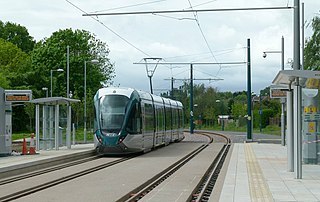
David Lane is a tram station on Nottingham Express Transit, in the city of Nottingham suburb of Basford. The tram lines here run parallel to the Robin Hood railway line that links Nottingham with Worksop, but there is no corresponding railway station. Both tram and railway lines have two tracks, and the resulting four tracks cross David Lane on a pair of parallel level crossings. The tram stop comprises a pair of side platforms on both sides of the tramway.

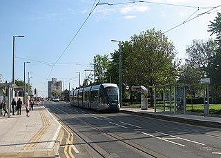
Phoenix Park is a tram stop on the Nottingham Express Transit (NET) light rail system, in the city of Nottingham suburb of Bulwell. It serves as one of the two northern termini of the NET's initial system, and is at the end of the short single line branch from Highbury Vale. The stop has a single island platform, flanked by two stub tracks which are segregated from the adjacent road. Phoenix Park serves as one of several park and ride stops on the NET network, with more than 600 car parking spaces located next to the stop.

The Forest is a tram stop on Nottingham Express Transit (NET) in the city of Nottingham. It takes its name from the nearby Forest Recreation Ground, the site of the city's famous annual Goose Fair. The Forest serves as one of several park and ride stops on the NET network, with more than 950 car parking spaces located next to the stop.

Lace Market is a tram stop of the Nottingham Express Transit (NET) in the centre of the city of Nottingham. It is situated on Fletcher Gate in Nottingham's historic Lace Market quarter, from which it derives its name, and near to the Hockley quarter.

Clifton Centre is a tram stop on the Nottingham Express Transit (NET) network in the city of Nottingham suburb of Clifton. It is situated on street track within Southchurch Drive, and comprises a single island platform situated between the running tracks. The stop is on line 2 of the NET, from Clifton via the city centre to Phoenix Park. Trams run at frequencies that vary between 4 and 8 trams per hour, depending on the day and time of day. To the south of the stop, a reversing siding is located between the running tracks, allowing trams from the city centre to terminate at Clifton Centre and stand clear of through services.

Wilkinson Street is a tram stop on Nottingham Express Transit (NET), in the city of Nottingham suburb of Basford. The tram stop opened on 9 March 2004, along with NET's initial system. It is one of several park and ride stops on the NET network, with more than 600 car parking spaces located next to the stop. NET's Wilkinson Street depot is also adjacent to the stop, and provides storage and maintenance facilities for all the system's trams, having been expanded to cope with the additional trams ordered for phase two. The depot also contains NET's offices, staff facilities and control room.

Queens Walk is a tram stop on the Nottingham Express Transit (NET) network, previously known as Meadows Centre. The stop is situated on Queens Walk in the Meadows area of the city of Nottingham. It is situated on reserved track and comprises a pair of side platforms flanking the tracks. The stop is on line 2 of the NET, from Phoenix Park via the city centre to Clifton, and trams run at frequencies that vary between 4 and 8 trams per hour, depending on the day and time of day.

Gregory Street is a tram stop on the Nottingham Express Transit (NET) network in the city of Nottingham. It is situated on street track within Lenton Lane, close to that lane's junction with Abbey Street and Gregory Street, and comprises a single island platform situated between the tracks. The stop is on line 1 of the NET, from Hucknall via the city centre to Beeston and Chilwell. Trams run at frequencies that vary between 4 and 8 trams per hour, depending on the day and time of day.

Wilford Lane is a tram stop on the Nottingham Express Transit (NET) network, in the titular city, England. The stop takes its name from Wilford Lane and the village of Wilford, and lies on the boundary between the city of Nottingham and the district of Rushcliffe. The stop is on line 2 of the NET, from Phoenix Park via the city centre to Clifton, and trams run at frequencies that vary between 4 and 8 trams per hour, depending on the day and time of day.

Ruddington Lane is a tram stop on the Nottingham Express Transit (NET) network. The stop takes its name from Ruddington Lane, which is crossed on the level just south of the stop, and lies on the boundary between the city of Nottingham and the district of Rushcliffe. The stop is on line 2 of the NET, from Phoenix Park via the city centre to Clifton, and trams run at frequencies that vary between 4 and 8 trams per hour, depending on the day and time of day.

Toton Lane is a tram stop and park and ride site on the Nottingham Express Transit network, serving the suburb of Chilwell and town of Stapleford, Broxtowe in Nottinghamshire, England.

Clifton South is a tram stop and Park & Ride site on the Nottingham Express Transit (NET) network. It is situated in the Borough of Rushcliffe, just to the south-west of the large City of Nottingham suburb of Clifton, on the A453. The Park & Ride site has a capacity of over 1000 cars. There is also an interchange with local bus services.

Summerwood Lane is a tram stop on the Nottingham Express Transit (NET) network in the city of Nottingham suburb of Clifton. It is situated on street track within Farnborough Road close to its junction with Summerwood Lane, and comprises a single island platform situated between the tracks. The stop is on line 2 of the NET, from Clifton via the city centre to Phoenix Park. Trams run at frequencies that vary between 4 and 8 trams per hour, depending on the day and time of day.
Rivergreen is a tram stop on the Nottingham Express Transit (NET) network in the city of Nottingham suburb of Clifton. It is situated on street track on Southchurch Drive near its junction with Rivergreen, and comprises a pair of side platforms flanking the running tracks. The stop is on line 2 of the NET, from Clifton via the city centre to Phoenix Park. Trams run at frequencies that vary between 4 and 8 trams per hour, depending on the day and time of day.
Cator Lane is a tram stop on the Nottingham Express Transit (NET) network, in the district of Broxtowe and suburb of Chilwell. It is situated on reserved track close to a crossing over Cator Lane, and has side platforms flanking the track. Trams run at frequencies that vary between 4 and 8 trams per hour, depending on the day and time of day.
Noel Street is a tram stop on Nottingham Express Transit (NET), in the city of Nottingham suburb of Hyson Green. The tram stop opened on 9 March 2004, along with NET's initial system. It is located on a one way section of the tramway, and is served only by northbound trams; the nearest southbound stop is the Hyson Green Market tram stop. The tram stop is located on a contra-flow reserved track alongside Noel Street, which is at this point one way southbound, and has a single side platform flanking the single track.

Beaconsfield Street is a tram stop on Nottingham Express Transit (NET), in the city of Nottingham suburb of Hyson Green. The tram stop opened on 9 March 2004, along with NET's initial system. It is located on a one way section of the tramway, and is served only by northbound trams; the nearest southbound stop is the Radford Road tram stop. The tram stop is located on street track in Noel Street at its junction with Beaconsfield Street. Noel Street is at this point one way northbound, and the stop has a single side platform flanking the single track.

Shipstone Street is a tram stop on Nottingham Express Transit (NET), in the city of Nottingham suburb of Hyson Green. The tram stop opened on 9 March 2004, along with NET's initial system. It is located on a one way section of the tramway, and is served only by northbound trams; the nearest southbound stop is the Radford Road tram stop. The tram stop is located on street track in Shipstone Street and adjacent to Shipstone Street play area. The stop has a single side platform flanking the single track.

