
Nottingham Express Transit (NET) is a 20-mile (32 km) tram system in Nottingham, England.

Bulwell station, previously known as Bulwell Market station, is a railway station and tram stop serving the town of Bulwell, in Nottinghamshire, England. It is located on the Robin Hood Line and the Hucknall branch of the Nottingham Express Transit (NET).

The Forest is a tram stop on Nottingham Express Transit (NET) in the city of Nottingham. It takes its name from the nearby Forest Recreation Ground, the site of the city's famous annual Goose Fair. The Forest serves as one of several park and ride stops on the NET network, with more than 950 car parking spaces located next to the stop.

Wilford Village is a tram stop on the Nottingham Express Transit (NET) network in the city of Nottingham. The stop takes its name from the village of Wilford on the south bank of the River Trent, and is situated between that village and the Wilford Toll Bridge that takes the tramway across the river. It is situated on reserved track and comprises a single island platform situated between the tracks. The stop is on line 2 of the NET, from Phoenix Park via the city centre to Clifton, and trams run at frequencies that vary between 4 and 8 trams per hour, depending on the day and time of day.

University of Nottingham is a tram stop on the Nottingham Express Transit (NET) network in the English city of Nottingham and adjacent to the University Park Campus of the University of Nottingham. It is situated on reserved track between University Boulevard (A6005) and the campus, and comprises a pair of side platforms flanking the tracks. The stop is on line 1 of the NET, from Hucknall via the city centre to Beeston and Chilwell. Trams run at frequencies that vary between 4 and 8 trams per hour, depending on the day and time of day.

Clifton Centre is a tram stop on the Nottingham Express Transit (NET) network in the city of Nottingham suburb of Clifton. It is situated on street track within Southchurch Drive, and comprises a single island platform situated between the running tracks. The stop is on line 2 of the NET, from Clifton via the city centre to Phoenix Park. Trams run at frequencies that vary between 4 and 8 trams per hour, depending on the day and time of day. To the south of the stop, a reversing siding is located between the running tracks, allowing trams from the city centre to terminate at Clifton Centre and stand clear of through services.

Meadows Embankment is a tram stop on the Nottingham Express Transit (NET) network. The stop is situated in the Meadows area of the city of Nottingham just to the north of the Wilford Toll Bridge across the River Trent. It is situated on reserved track and comprises a pair of side platforms flanking the tracks. The stop is on line 2 of the NET, from Phoenix Park via the city centre to Clifton, and trams run at frequencies that vary between 4 and 8 trams per hour, depending on the day and time of day.

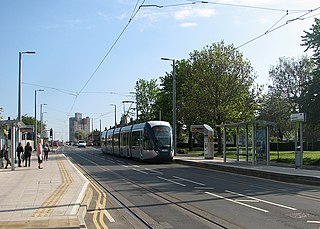
Moor Bridge is a tram stop on the Nottingham Express Transit (NET) light rail system in the city of Nottingham in the suburb of Bulwell. It is part of the NET's initial system, and is situated on the long single line section between Bulwell and Hucknall tram stops that runs alongside the Robin Hood railway line. Like all the other intermediate stops on this section, the stop has a passing loop with an island platform situated between the two tracks of the loop.

Meadows Way West is a tram stop on the Nottingham Express Transit (NET) network, previously known as Meadows North. The stop is situated on Meadows Way in the Meadows area of the city of Nottingham. The stop is on line 1 of the NET, from Hucknall via the city centre to Beeston and Chilwell.

The Beeston transport interchange, also known as Beeston Centre tram stop, is an interchange between the trams of the Nottingham Express Transit (NET) network and local buses. It is in the centre of the town of Beeston in Nottinghamshire, England. The interchange is some 750 metres (0.5 mi) north-west of Beeston railway station.

Gregory Street is a tram stop on the Nottingham Express Transit (NET) network in the city of Nottingham. It is situated on street track within Lenton Lane, close to that lane's junction with Abbey Street and Gregory Street, and comprises a single island platform situated between the tracks. The stop is on line 1 of the NET, from Hucknall via the city centre to Beeston and Chilwell. Trams run at frequencies that vary between 4 and 8 trams per hour, depending on the day and time of day.

NG2 is a tram stop on the Nottingham Express Transit (NET) network in the city of Nottingham. It is situated on street track within Enterprise Way, in the Ng2 business park from which it takes its name, and comprises a pair of side platforms flanking the tracks. The stop is on line 1 of the NET, from Hucknall via the city centre to Beeston and Chilwell. Trams run at frequencies that vary between 4 and 8 trams per hour, depending on the day and time of day.

University Boulevard is a tram stop on the Nottingham Express Transit (NET) network in the city of Nottingham. It is situated on reserved track alongside University Boulevard (A6005) close to the boulevard's junction with Queen's Road East and Lower Road, and comprises a pair of side platforms flanking the tracks. The stop is on line 1 of the NET, from Hucknall via the city centre to Beeston and Chilwell. Trams run at frequencies that vary between 4 and 8 trams per hour, depending on the day and time of day.

Middle Street is a tram stop on the Nottingham Express Transit (NET) network in the town of Beeston. It is situated on street track within Middle Street and comprises a single island platform situated between the tracks. The stop is on line 1 of the NET, from Hucknall via the city centre to Beeston and Chilwell. Trams run at frequencies that vary between 4 and 8 trams per hour, depending on the day and time of day.

Clifton South is a tram stop and Park & Ride site on the Nottingham Express Transit (NET) network. It is situated in the Borough of Rushcliffe, just to the south-west of the large City of Nottingham suburb of Clifton, on the A453. The Park & Ride site has a capacity of over 1000 cars. There is also an interchange with local bus services.

Summerwood Lane is a tram stop on the Nottingham Express Transit (NET) network in the city of Nottingham suburb of Clifton. It is situated on street track within Farnborough Road close to its junction with Summerwood Lane, and comprises a single island platform situated between the tracks. The stop is on line 2 of the NET, from Clifton via the city centre to Phoenix Park. Trams run at frequencies that vary between 4 and 8 trams per hour, depending on the day and time of day.

Holy Trinity is a tram stop on the Nottingham Express Transit (NET) network in the City of Nottingham suburb of Clifton. It takes its name from the nearby Holy Trinity Church. It is situated on a short stretch of reserved track at the junction of Southchurch Drive and Farnborough Road, and comprises a pair of side platforms flanking the running tracks. The stop is on line 2 of the NET, from Clifton via the city centre to Phoenix Park. Trams run at frequencies that vary between 4 and 8 trams per hour, depending on the day and time of day.
Rivergreen is a tram stop on the Nottingham Express Transit (NET) network in the city of Nottingham suburb of Clifton. It is situated on street track on Southchurch Drive near its junction with Rivergreen, and comprises a pair of side platforms flanking the running tracks. The stop is on line 2 of the NET, from Clifton via the city centre to Phoenix Park. Trams run at frequencies that vary between 4 and 8 trams per hour, depending on the day and time of day.

Southchurch Drive, also known as Southchurch Drive North, is a tram stop on the Nottingham Express Transit (NET) network in the city of Nottingham suburb of Clifton. It is situated on street track on Southchurch Drive near its junction with Farnborough Road, and is one of four such tram stops situated on or adjacent to Southchurch Drive, the others being Rivergreen, Clifton Centre and Holy Trinity.
High Road – Central College is a tram stop on the Nottingham Express Transit (NET) network, in the district of Broxtowe, East Midlands, United Kingdom. The stop lies immediately to the Beeston side of the boundary between the suburbs of Chilwell and Beeston. The original proposed name for the stop was Castle College, and some publications still use that name.


