Nottingham Express Transit (NET) is a 32-kilometre-long (20 mi) tram system in Nottingham, England. The system opened to the public on 9 March 2004 and a second phase, that more than doubled the size of the total system, opened on 25 August 2015, having been initially planned to open two years earlier.

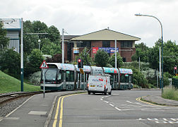
High School is a tram stop on Nottingham Express Transit (NET) in the city of Nottingham suburb of the Arboretum. It takes its name from the nearby Nottingham High School, and is situated in Waverley Street at its intersection with Gedling Grove, an intersection that has been closed to road vehicles by the construction of the stop. The tram tracks here share the road with other traffic, and the stop has two side platforms on either side of the twin tracks, which are themselves separated by a traffic island intended to prevent road vehicles overtaking stationary trams.
Highbury Vale is a stop on the Nottingham Express Transit tram system in the city of Nottingham near the boundary between the suburbs of Basford and Bulwell. It serves as the main interchange between the Hucknall and Phoenix Park branches of the initial system - however, NET recommends that people alight at the previous stop rather than change at Highbury Vale, due to the lines splitting at Babbington junction, just before the trams reach the stop.

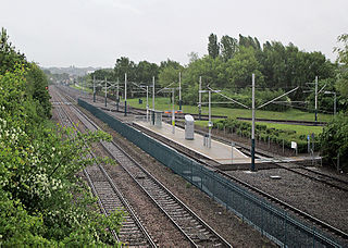
David Lane is a tram station on Nottingham Express Transit, in the city of Nottingham suburb of Basford. The tram lines here run parallel to the Robin Hood railway line that links Nottingham with Worksop, but there is no corresponding railway station. Both tram and railway lines have two tracks, and the resulting four tracks cross David Lane on a pair of parallel level crossings. The tram stop comprises a pair of side platforms on both sides of the tramway.

Nottingham Trent University is a tram stop on Nottingham Express Transit (NET) in the city of Nottingham suburb of the Arboretum. It is located in the centre of Nottingham Trent University's city campus, between the Boots Library and the Chaucer Building. The university's flagship Arkwright and Newton buildings are nearby to the south, although Newton is closer to the Royal Centre stop. On either side of the stop, the tram tracks share the road with other traffic, but only trams are permitted to pass through the stop itself. The stop has two side platforms on either side of the twin tracks.

Old Market Square is a tram stop of Nottingham Express Transit (NET) in the centre of the city of Nottingham. It is situated on the South Parade of Nottingham's Old Market Square, from which it derives its name, and is the most central of the system's stops. The location is a high-profile one, benefiting from the long views and high pedestrian footfall of the market square. It is also adjacent to the city's Council House, and is an important interchange point with the city's buses.

The Forest is a tram stop on Nottingham Express Transit (NET) in the city of Nottingham. It takes its name from the nearby Forest Recreation Ground, the site of the city's famous annual Goose Fair. The Forest serves as one of several park and ride stops on the NET network, with more than 950 car parking spaces located next to the stop.

Lace Market is a tram stop of the Nottingham Express Transit (NET) in the centre of the city of Nottingham. It is situated on Fletcher Gate in Nottingham's historic Lace Market quarter, from which it derives its name, and near to the Hockley quarter.
Basford is a tram station on Nottingham Express Transit (NET), in the city of Nottingham suburb of Basford. The tram lines here run parallel to the Robin Hood railway line that links Nottingham with Worksop, but there is no corresponding railway station. Both tram and railway lines have two tracks, and the resulting four tracks are crossed by a pedestrian bridge. The tram stop comprises a pair of side platforms on both sides of the tramway.
Cinderhill is a tram stop on the Nottingham Express Transit (NET) light rail system in the city of Nottingham on the boundary between the suburbs of Basford and Bulwell. It was part of the NET's initial system, and is situated in the middle of the short single line branch between Highbury Vale and Phoenix Park tram stops. The stop comprises a single platform and track, situated in a cutting between two bridges and served by trams running in both directions.

Wilkinson Street is a tram stop on Nottingham Express Transit (NET), in the city of Nottingham suburb of Basford. The tram stop opened on 9 March 2004, along with NET's initial system. It is one of several park and ride stops on the NET network, with more than 600 car parking spaces located next to the stop. NET's Wilkinson Street depot is also adjacent to the stop, and provides storage and maintenance facilities for all the system's trams, having been expanded to cope with the additional trams ordered for phase two. The depot also contains NET's offices, staff facilities and control room.

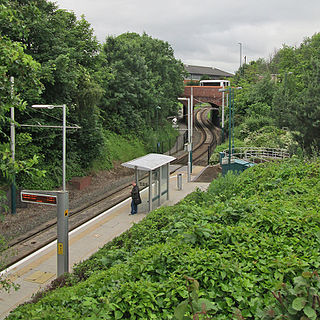
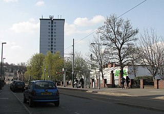
Moor Bridge is a tram stop on the Nottingham Express Transit (NET) light rail system in the city of Nottingham in the suburb of Bulwell. It is part of the NET's initial system, and is situated on the long single line section between Bulwell and Hucknall tram stops that runs alongside the Robin Hood railway line. Like all the other intermediate stops on this section, the stop has a passing loop with an island platform situated between the two tracks of the loop.

Toton Lane is a tram stop and park and ride site on the Nottingham Express Transit network, serving the suburb of Chilwell and town of Stapleford, Broxtowe in Nottinghamshire, England.

Clifton South is a tram stop and Park & Ride site on the Nottingham Express Transit (NET) network. It is situated in the Borough of Rushcliffe, just to the south-west of the large City of Nottingham suburb of Clifton, on the A453. The Park & Ride site has a capacity of over 1000 cars. There is also an interchange with local bus services.

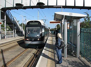
Summerwood Lane is a tram stop on the Nottingham Express Transit (NET) network in the city of Nottingham suburb of Clifton. It is situated on street track within Farnborough Road close to its junction with Summerwood Lane, and comprises a single island platform situated between the tracks. The stop is on line 2 of the NET, from Clifton via the city centre to Phoenix Park. Trams run at frequencies that vary between 4 and 8 trams per hour, depending on the day and time of day.
Noel Street is a tram stop on Nottingham Express Transit (NET), in the city of Nottingham suburb of Hyson Green. The tram stop opened on 9 March 2004, along with NET's initial system. It is located on a one way section of the tramway, and is served only by northbound trams; the nearest southbound stop is the Hyson Green Market tram stop. The tram stop is located on a contra-flow reserved track alongside Noel Street, which is at this point one way southbound, and has a single side platform flanking the single track.

Beaconsfield Street is a tram stop on Nottingham Express Transit (NET), in the city of Nottingham suburb of Hyson Green. The tram stop opened on 9 March 2004, along with NET's initial system. It is located on a one way section of the tramway, and is served only by northbound trams; the nearest southbound stop is the Radford Road tram stop. The tram stop is located on street track in Noel Street at its junction with Beaconsfield Street. Noel Street is at this point one way northbound, and the stop has a single side platform flanking the single track.

Cinderhill is an area in the City of Nottingham. It is located roughly 3.1 miles (5.0 km) from the City Centre, and surrounding areas include Bulwell to the north, Aspley and Broxtowe to the south, Basford to the east and Nuthall to the west.
Babbington Colliery, also known as Cinderhill Colliery, was a coal mine in Cinderhill, Nottinghamshire, England. The mine opened in 1841, and was the first large-scale coal mine in the county. It took its name from its original owner, the Babbington Coal Company, founded in 1839 to work shallow mines near Babbington, a hamlet some 2.5 miles (4.0 km) to the west of the later colliery. Babbington Colliery had a long life, and did not close until 1986.