Branchville, Georgia | |
|---|---|
 Branchville  Branchville | |
| Coordinates: 31°09′02″N84°18′56″W / 31.1506°N 84.3156°W | |
| Country | United States |
| State | Georgia |
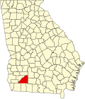
| County | Mitchell |
| Area | |
• Total | 98.5 sq mi (255 km2) |
| Elevation | 140 ft (40 m) |
| Population (2007) | |
• Total | 1,090 |
| • Density | 11/sq mi (4/km2) |
| Time zone | UTC-5 (Eastern (EST)) |
| • Summer (DST) | UTC-4 (EDT) |
| Area code | 229 |
Branchville is an unincorporated community located in Mitchell County, Georgia, United States. [1]