Sale City, Georgia | |
|---|---|
 | |
| Coordinates: 31°15′47″N84°1′20″W / 31.26306°N 84.02222°W | |
| Country | United States |
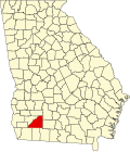
| State | Georgia |
| County | Mitchell |
| Area | |
• Total | 1.84 sq mi (4.75 km2) |
| • Land | 1.83 sq mi (4.75 km2) |
| • Water | 0.00 sq mi (0.00 km2) |
| Elevation | 358 ft (109 m) |
| Population | |
• Total | 354 |
| • Density | 193.02/sq mi (74.54/km2) |
| Time zone | UTC-5 (Eastern (EST)) |
| • Summer (DST) | UTC-4 (EDT) |
| ZIP code | 31784 |
| Area code | 229 |
| FIPS code | 13-68096 [3] |
| GNIS feature ID | 0322327 [4] |
Sale City is a town in Mitchell County, Georgia, United States. The population was 354 at the 2020 census. [2]