
Caress is an unincorporated community in Braxton County, West Virginia, United States.
Centralia is an unincorporated community in Braxton County, West Virginia, United States. It was so named because it is in the central part of a county which also happens to be at the geographic center of the state. Its ZIP code is 26601.
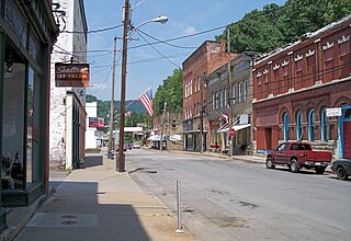
Sutton is a town in Braxton County, West Virginia, in the United States. The population was 994 at the 2010 census. It is the county seat of Braxton County. Sutton is situated at a center of transportation in West Virginia. Interstate 79, a major north-south route, connects with Appalachian Corridor L, another significant north-south route, just a few miles south of town.

The Little Kanawha River is a tributary of the Ohio River, 169 mi (269 km) long, in western West Virginia in the United States. Via the Ohio, it is part of the watershed of the Mississippi River, draining an area of 2,320 mi² (6,009 km²) on the unglaciated portion of the Allegheny Plateau. It served as an important commercial water route in the early history of West Virginia, particularly in the logging and petroleum industries.

West Virginia's 1st congressional district is located in the northern part of the state. It is the most regularly drawn of the state's three districts.
Gip is an unincorporated community in Braxton County, West Virginia, United States. Gip's elevation is 932 feet and is in the Eastern time zone.

Samuel Price was Virginia lawyer and politician, who helped to establish the state of West Virginia during the American Civil War and became Lieutenant Governor, and later a United States Senator.

This is a list of the National Register of Historic Places listings in Braxton County, West Virginia.
Rollyson is an unincorporated community in Braxton County, West Virginia, United States. Rollyson is located along West Virginia Route 5, the CSX Railroad, and Saltlick Creek 4.2 miles (6.8 km) north of Flatwoods.
Gem is an unincorporated community in Braxton County, West Virginia, United States. Gem is located on West Virginia Route 5, the CSX Railroad, and Saltlick Creek 2 miles (3.2 km) south of Burnsville.
Corley is an unincorporated community in Braxton County, West Virginia, United States. Corley is located along Saltlick Creek and County Route 22 2.9 miles (4.7 km) east-northeast of Flatwoods.
Servia is an unincorporated community in Braxton County, West Virginia. Servia is located on County Route 11 and Duck Creek near Interstate 79, 13.7 miles (22.0 km) west-southwest of Sutton.
Glendon is an unincorporated community in Braxton County, West Virginia, United States. Glendon is located along West Virginia Route 4 and the Elk River 10.9 miles (17.5 km) west-southwest of Sutton. Glendon had a post office, which opened on July 31, 1889, and closed on November 5, 1994.
Herold is an unincorporated community in Braxton County, West Virginia, United States. Herold is located along the Birch River and County Route 40 8.6 miles (13.8 km) southwest of Sutton. Herold had a post office, which opened on September 3, 1891, and closed on December 23, 1984.
Wilsie is an unincorporated community in Braxton County, West Virginia, United States. Wilsie is located along County Route 9 6.1 miles (9.8 km) west of Gassaway. Wilsie had a post office, which closed on July 23, 2005.
Clem is an unincorporated community in Braxton County, West Virginia, United States. Clem is located along County Route 30 11.25 miles (18.11 km) west-southwest of Sutton.
Riffle is an unincorporated community in Braxton County, West Virginia, United States. Riffle is located along the Elk River Railroad at the junction of County Routes 5/6, 6/6, and 7/6, 5.75 miles (9.25 km) north-northwest of Sutton.
McNutt is an unincorporated community in Braxton County, West Virginia, United States.
Laurel Fork is an unincorporated community in Braxton County, West Virginia, United States.


