
Algonquin Provincial Park is an Ontario provincial park located between Georgian Bay and the Ottawa River, mostly within the Unorganized South Part of Nipissing District. Established in 1893, it is the oldest provincial park in Canada. Additions since its creation have increased the park to its current size of about 7,653 km2 (2,955 sq mi). The park is contiguous with several smaller, administratively separate provincial parks that protect important rivers in the area, resulting in a larger total protected area.

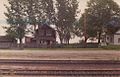
Achray is an unincorporated place and former railway point in geographic Stratton Township in the Unorganized South Part of Nipissing District in northeastern Ontario, Canada. It lies in northern Algonquin Provincial Park on the northern shore of Grand Lake, part of the Barron River system, and functions today as a campground site.

The Barron River is a river in the Saint Lawrence River drainage basin in Nipissing District and Renfrew County, Ontario, Canada. It flows from Clemow Lake in northern Algonquin Provincial Park and joins the Petawawa River, whose southern branch it forms, in the municipality of Laurentian Hills, near the municipality of Petawawa.
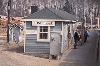
Kiosk is an unincorporated place and former railway point and community in geographic Pentland Township in the Unorganized South Part of Nipissing District in northeastern Ontario, Canada. Kiosk is surrounded by but not within Algonquin Provincial Park, for which it provides a road access point via Ontario Highway 630, and is located on Kioshkokwi Lake on the Amable du Fond River on the right bank of the outlet of that river from the lake and across the river from the unincorporated place of Coristine. The name "Kiosk" is an abbreviated form of the lake's name, which means "lake of many gulls".
Cedar Lake is a lake in the geographic townships of Boyd, Deacon and Lister in the Unorganized south part of Nipissing District in northeastern Ontario, Canada. The lake is in the Saint Lawrence River drainage basin and is entirely within Algonquin Provincial Park; it is a popular entry point for canoe trips into the interior of the park as the community of Brent, located on the lake, is connected by Brent Road to Ontario Highway 17. Other places on the lake are Acanthus and Government Park.
Kearney is a town and municipality in the Almaguin Highlands region of Parry Sound District of Ontario, Canada. With a landmass of 528 square kilometres and a year-round population of 974 in the Canada 2021 Census, Kearney claims to be the "Biggest Little Town in Ontario."
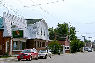
South River is a village on Highway 124 near Algonquin Park in the Almaguin Highlands region of Parry Sound District of Ontario, Canada. It is about halfway between North Bay and Huntsville or a 3-hour drive (300 km) north from Toronto. South River has access to the Algonquin Park for canoeists at Kawawaymog. South River is home of Mikisew Provincial Park on the shores of Eagle Lake.

Opeongo River Provincial Park is a waterway park in Nipissing District in northeastern Ontario, Canada. It incorporates those portions of the Opeongo River from its exit from Algonquin Provincial Park to the river's mouth at the Madawaska River, except for a small portion around Victoria Lake. The park has two access points: from Ontario Highway 60 west of the community of Madawaska; and the Shall Lake access point, north of Victoria Lake, in Algonquin Provincial Park.
The Ottawa, Arnprior and Parry Sound Railway, or OA&PS, is a historic railway that operated in central and eastern Ontario, Canada from 1897 until 1959. It was, for a time, the busiest railway route in Canada, carrying both timber and wood products from today's Algonquin Provincial Park areas, as well as up to 40% of the grain traffic from the Canadian west from Depot Harbour at Parry Sound through to the St. Lawrence River valley.

South Algonquin is a township municipality in Nipissing District, Ontario, Canada. Located south of Algonquin Provincial Park, it is the sole populated portion of the district that lies south of the traditional dividing line between Northern Ontario and Southern Ontario and is closer connected to Renfrew County as opposed to the core portions of Nipissing District.
Stuart is the name of an unincorporated place and former railway point in geographic White Township in the Unorganized South Part of Nipissing District in northeastern Ontario, Canada. Stuart is located within Algonquin Provincial Park on Travers Creek.
Dahlia is an unincorporated place and former railway point in geographic Master Township in the Unorganized South Part of Nipissing District in northeastern Ontario, Canada. Dahlia is located within Algonquin Provincial Park on the Indian River.
Indian is an unincorporated place and former railway point in the incorporated township of Laurentian Valley in Renfrew County, eastern Ontario, Canada. Indian is located on the Indian River just southeast of the southeast corner of Algonquin Provincial Park.
Government Park is an unincorporated place and former railway point in geographic Boyd Township in the Unorganized South Part of Nipissing District in northeastern Ontario, Canada. Government Park is located within Algonquin Provincial Park on Cedar Lake on the Petawawa River.
Daventry is an unincorporated place and former railway point in geographic Boyd Township in the Unorganized South Part of Nipissing District in northeastern Ontario, Canada. Daventry is located within Algonquin Provincial Park on Little Cauchon Lake.
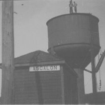
Ascalon is an unincorporated place and former railway point in geographic Pentland Township in the Unorganized South Part of Nipissing District in northeastern Ontario, Canada. Ascalon is located within Algonquin Provincial Park at the northwestern end of Mink Lake in the Amable du Fond River drainage basin.
Coristine is an unincorporated place and former railway point in geographic Pentland Township in the Unorganized South Part of Nipissing District in northeastern Ontario, Canada. Coristine is located within Algonquin Provincial Park on Kioshkokwi Lake on the Amable du Fond River, on the right bank of the outlet of that river from the lake and opposite the settlement of Kiosk.
Kilrush is an unincorporated place and former railway point in geographic Boulter Township in the Unorganized South Part of Nipissing District in northeastern Ontario, Canada. Kilrush is located northwest of the northwest side of Algonquin Provincial Park on Kilrush Lake in the Amable du Fond River drainage basin.

The Groundhog River is a river in Cochrane District and Sudbury District in Northeastern Ontario, Canada. The river is in the James Bay drainage basin and is a left tributary of the Mattagami River.

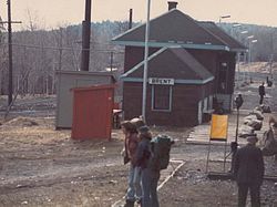
The Canadian National Railway's Beachburg Subdivision or "Beachburg Sub" for short, was part of the former Transcontinental Mainline. The Beachburg Sub connected Ottawa to Brent, Ontario.


