Petawawa River

Last updated
Petawawa River
Crooked Chute Petawawa.jpg
The dangerous Crooked Chute in Algonquin Provincial Park
Canada Ontario relief location map.jpg
Red pog.svg
Location of the mouth of the Petawawa River in Ontario
EtymologyFrom the Algonquian for "where one hears a noise like this"
Location
Country Canada
Province Ontario
Regions
County/District
Physical characteristics
SourceRalph Bice Lake
  locationGeographic township of Butt, Unorganized South Part, Nipissing District
  coordinates 45°40′49″N78°57′02″W / 45.68028°N 78.95056°W / 45.68028; -78.95056
  elevation443 m (1,453 ft)
Mouth Ottawa River
  location
Petawawa, Renfrew County
  coordinates
45°54′38″N77°15′31″W / 45.91056°N 77.25861°W / 45.91056; -77.25861
  elevation
110 m (360 ft)
Length187 km (116 mi)
Basin size4,200 km2 (1,600 sq mi)
Discharge 
  average45 m3/s (1,600 cu ft/s)
Basin features
Progression Ottawa RiverSt. Lawrence RiverGulf of St. Lawrence
River system Ottawa River drainage basin
Tributaries 
  left North River, Nipissing River, Tim River
  right Barron River, Crow River, Little Madawaska River

The Petawawa River is a river in the Saint Lawrence River drainage basin in Nipissing District and Renfrew County in eastern and northeastern Ontario, Canada. [1] [2] The river flows from Algonquin Provincial Park to the Ottawa River at the town of Petawawa, and is only one of two major tributaries of the Ottawa River to flow completely freely (the other being the Dumoine River). [3] The river's name comes from the Algonquian for "where one hears a noise like this", which refers to its many rapids.

Contents

Course

The river starts at Ralph Bice Lake (formerly Butt Lake) in northern Algonquin Provincial Park in the geographic township of Butt in the Unorganized South Part of Nipissing District. It flows south to Daisy Lake then east to Big Trout Lake. The river heads north out the lake over Big Trout Lake Dam, takes in the left tributary Tim River, flows over the Portal Rapids, Cedar Rapids, Snowshoe Rapids, Catfish Rapids, and Stacks Rapids to reach Cedar Lake, the location of the community of Brent, where it takes in the left tributary Nipissing River. The river exits the lake over a dam, heads through the Devil's Chute, reaches Radiant Lake, where it takes in the left tributary North River and right tributary Little Madawaska River, and passes through the Squirrel Rapids, Big Sawyer Rapids, Battery Rapids Cascade Rapids and White Horse Rapids, and takes in the right tributary Crow River. The river then continues through a series of rapids including the Devil's Cellar Rapids, passes the Algonquin Radio Observatory, and reaches Lake Travers. The Petawawa River enters a canyon and passes through numerous rapids including the Big Thompson Rapids, Little Thompson Rapids, Grillade Rapids, Crooked Chute, Rollway Rapids, The Natch, Schooner Rapids, Five Mile Rapids to arrive at Whitson Lake adjacent to the Petawawa Hills. It leaves Algonquin Provincial Park and enters the municipality of Laurentian Hills in Renfrew County, continues southeast past CFB Petawawa, passes through the Crooked Rapids, Race Horse Rapids, White Horse Rapids and Halfmile Rapids, and reaches Lac du Bois Dur, where it takes in the right tributary Barron River. The river enters the town of Petawawa, heads under Ontario Highway 17, through the Big Eddy Rapids, under the Canadian Pacific Railway main line, and empties into Black Bay on the Ottawa River.

The river is 187 kilometres (116 mi) in length and drains an area of 4,200 square kilometres (1,600 sq mi), with a mean discharge of 45 cubic metres (1,589 cu ft) per second. [4]

Economy

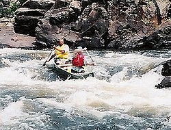
From the late 19th century until the 1960s, the river was used for log driving of the timber from the forested areas surrounding the river. The river is visited by canoeing and kayaking enthusiasts - both for its white water rapids and its views.

In 2009, based on subsidized power-generation rates in the Ontario Green Energy Act's Feed-in-Tariff (FIT) program, there were plans to build a 5.3 MW hydro-electric generating station at Big Eddy Rapids, about 2 kilometres (1.2 mi) upstream from the river's mouth. The project involved building a concrete and boulder weir that would direct a portion of the water to a new 300 metres (980 ft) long intake channel and powerhouse, as well as a fish ladder. It was scheduled to be operational by 2015, but the project raised opposition from the local communities, paddlers, and environmental groups. [3] Both Big Eddy Rapids and Half Mile Rapids would have been affected. [5]

The project was among nineteen FIT hydro projects on ten rivers that were cancelled in 2015 after their FIT contracts were terminated following the opposition by groups like the Ontario Rivers Alliance. [5]

Geology

Part of the Petawawa River lies in the Ottawa-Bonnechere Graben, a 175 million year old rift valley.

Tributaries

The river as it runs through the town of Petawawa PetawawaRiver.JPG
The river as it runs through the town of Petawawa

Tributaries of the Petawawa River in upstream order:

See also

Related Research Articles

<span class="mw-page-title-main">York River (Ontario)</span> River in Ontario, Canada

The York River is a river in Renfrew County, Hastings County and Haliburton County in Ontario, Canada. The river is in the Saint Lawrence River drainage basin, and flows from the southern extension of Algonquin Provincial Park to the Madawaska River.

<span class="mw-page-title-main">Indian River (Muskrat River watershed)</span> River in Ontario, Canada

The Indian River is a river in Renfrew County and Nipissing District in Eastern and Northeastern Ontario, Canada. It is in the Saint Lawrence River drainage basin, and is a left tributary of the Muskrat River.

<span class="mw-page-title-main">Bonnechere River</span> River in Ontario, Canada

The Bonnechere River is a river in the Saint Lawrence River drainage basin in Nipissing District and Renfrew County in eastern and northeastern Ontario, Canada. The river flows from Algonquin Provincial Park to the Ottawa River east and north of the town of Renfrew. The river's name is thought to come from the French "bonne chère" meaning "good cheer".

<span class="mw-page-title-main">Opeongo River</span> River in Ontario, Canada

The Opeongo River is a river in the Saint Lawrence River drainage basin in Nipissing District in northeastern Ontario, Canada. The river is entirely within Algonquin Provincial Park and Opeongo River Provincial Park, except for a small portion around Victoria Lake, and is a left tributary of the Madawaska River.

<span class="mw-page-title-main">Barron River (Ontario)</span> River in Ontario, Canada

The Barron River is a river in the Saint Lawrence River drainage basin in Nipissing District and Renfrew County, Ontario, Canada. It flows from Clemow Lake in northern Algonquin Provincial Park and joins the Petawawa River, whose southern branch it forms, in the municipality of Laurentian Hills, near the municipality of Petawawa.

Cedar Lake is a lake in the geographic townships of Boyd, Deacon and Lister in the Unorganized south part of Nipissing District in northeastern Ontario, Canada. The lake is in the Saint Lawrence River drainage basin and is entirely within Algonquin Provincial Park; it is a popular entry point for canoe trips into the interior of the park as the community of Brent, located on the lake, is connected by Brent Road to Ontario Highway 17. Other places on the lake are Acanthus and Government Park.

Moore Creek is a creek in South Algonquin, Nipissing District in Northeastern Ontario, Canada. It is in the Saint Lawrence River drainage basin and is a left tributary of the Madawaska River.

Daisy Lake is a lake in the geographic townships of Butt and McCraney in the Unorganized South Part of Nipissing District, Ontario, Canada. The lake is in the Ottawa River drainage basin and is entirely within Algonquin Provincial Park.

<span class="mw-page-title-main">Grand Lake (Nipissing District)</span> Lake in the Ottawa River drainage basin

Grand Lake is a lake in the Ottawa River drainage basin in the geographic townships of Barron and Stratton in the Unorganized South Part of Nipissing District in Northeastern Ontario, Canada.

The Crow River is a river in the Saint Lawrence River drainage basin in the Unorganized South Part of Nipissing District in northeastern Ontario, Canada. The river lies entirely within Algonquin Provincial Park and is a right tributary of the Petawawa River.

The Little Madawaska River is a river in the Saint Lawrence River drainage basin in the Unorganized South Part of Nipissing District in northeastern Ontario, Canada. The river is entirely within Algonquin Provincial Park, and is a right tributary of the Petawawa River and not a tributary of the nearby Madawaska River.

The Nipissing River is a river in the Saint Lawrence River drainage basin in the Unorganized South Part of Nipissing District in northeastern Ontario, Canada. The river is entirely within Algonquin Provincial Park, and is a left tributary of the Petawawa River.

The Tim River is a river in the Saint Lawrence River drainage basin in the Unorganized South Part of Nipissing District in northeastern Ontario, Canada. The river is entirely within Algonquin Provincial Park, and is a left tributary of the Petawawa River.

<span class="mw-page-title-main">Big East River</span> River in Canada

The Big East River is a river in Muskoka District and Nipissing District in Northeastern Ontario, Canada. The river is in the Great Lakes Basin, is a left tributary of the Muskoka River, and flows from Algonquin Provincial Park to Huntsville.

Depot Creek is a river in Nipissing District in Northeastern Ontario, Canada. It is in the Saint Lawrence River drainage basin, is a tributary of Grand Lake on the Barron River, and lies entirely within Algonquin Provincial Park.

Mew Lake is a lake in Nipissing District in Northeastern Ontario, Canada. The lake is in Algonquin Provincial Park, is part of the Saint Lawrence River drainage basin, and lies astride Ontario Highway 60.

Pewee Lake is a lake in Nipissing District in Northeastern Ontario, Canada. The lake is in Algonquin Provincial Park, is part of the Saint Lawrence River drainage basin, and lies astride Ontario Highway 60.

Jack Lake is a lake in Nipissing District in Northeastern Ontario, Canada. The lake is in Algonquin Provincial Park, is part of the Saint Lawrence River drainage basin, and lies 750 metres (2,460 ft) north of Ontario Highway 60.

Jack Creek is a stream in Nipissing District in Northeastern Ontario, Canada. It is Algonquin Provincial Park, is a right tributary of the North Madawaska River, and is part of the Saint Lawrence River drainage basin.

McKenzie Lake is a lake in South Algonquin, Nipissing District and Hastings Highlands, Hastings County in Ontario, Canada. It is in the Saint Lawrence River drainage basin, is part of the Madawaska River river system, and lies about 14 kilometres (9 mi) south of the community of Madawaska and a similar distance north of the small town of Maynooth. The settlement of McKenzie Lake is on the north shore of the lake.

References

  1. "Petawawa River". Geographical Names Data Base . Natural Resources Canada . Retrieved 2011-07-24.
  2. "Petawawa River". Atlas of Canada . Natural Resources Canada. 2010-02-04. Retrieved 2011-07-24. Shows the river course.
  3. 1 2 Kelly Egan (September 26, 2012). "Muddy waters surround Petawawa dam project". Ottawa Citizen .
  4. "Rivers - Rivers Flowing into the Atlantic Ocean". Atlas of Canada - Facts about Canada. Natural Resources Canada. 2010-10-25. Retrieved 2011-07-24.
  5. 1 2 10 Ontario Rivers were protected from 19 Hydroelectric Projects - http://www.ontarioriversalliance.ca/10-ontario-rivers-protected-19-hydroelectric-projects/

Sources