Sorell is a town in Tasmania, Australia, north-east of Hobart. It is located on the Tasman Highway at the junction with the Arthur Highway. Sorell is one of Tasmania's oldest towns, being first settled in 1808 as a small farming community and becoming an official township in 1821. At the 2006 census, Sorell had a population of 1,546, and at the 2011 census, a population of 2,476. and at the 2016 census, a population of 2,907.

Rand is a town in the Riverina district of New South Wales, Australia. It is located in the Federation Council local government area. Based upon the 2011 census, Rand had a population of 575.

Euston is a small town on the banks of the Murray River, southern New South Wales, Australia in Balranald Shire. The twin town of Robinvale is on the other side of the river in the state of Victoria.

Port Campbell is a coastal town in Victoria, Australia. The town is on the Great Ocean Road, west of the Twelve Apostles, in the Shire of Corangamite. It is popular for day trips as the sandy beach is relatively safe to swim in. At the 2016 census, Port Campbell had a population of 478.

Finley is a town in the Riverina region of New South Wales, Australia. It is the largest town in the Berrigan Shire local government area. At the 2016 census, Finley had a population of 2,519 people. The town is located approximately 140 kilometres (87 mi) west of Albury on the intersection of the Newell Highway and Riverina Highways.

Wallendbeen is a small town in southern New South Wales, Australia, administered by Cootamundra-Gundagai Regional Council. At the 2011 census, Wallendbeen and the surrounding area had a population of 305. The town's name is derived from an aboriginal word for "stony hill".

Dargo is a town in Victoria, Australia, located 348 kilometres (216 mi) east of Melbourne, in the Shire of Wellington. At the 2016 census, Dargo and the surrounding area had a population of 99. The median age of residents was 63.

Humula is a small country town between Tarcutta and Tumbarumba in New South Wales, Australia. Humula was once named "American Yards" or "American Fields" during the gold rush, where many Chinese came for gold years ago. At the 2016 census, Humula had a population of 124 people.

Patchewollock is a town in north-west Victoria, Australia. At the 2016 census, Patchewollock had a population of 133.
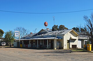
Blighty is a small town in the Riverina region of New South Wales, Australia. The town lies on the Riverina Highway between the towns of Finley and Deniliquin. It is located in the Edward River Council local government area. At the 2011 census, Blighty and the surrounding area had a population of 396.

Wakool is a town in the western Riverina region of New South Wales, Australia. Wakool is in the Murray River Council local government area, 791 kilometres (492 mi) south west of the state capital, Sydney and 336 kilometres (209 mi) north-west of Melbourne. At the 2016 census, Wakool had a population of 297.
Hanwood is a town in the central Riverina region of New South Wales, Australia. The town is located 5 kilometres south of Griffith, New South Wales and is in the City of Griffith local government area. At the 2011 census, Hanwood had a population of 1,490.
Marrar is a town in the central east part of the Riverina region of New South Wales. Australia. The town is situated about 21 kilometres (13 mi) west of Old Junee and 32 kilometres (20 mi) north of Downside. At the 2016 census, Marrar had a population of 368.

Woomargama is a locality in southeastern New South Wales, Australia. The locality is in the South West Slopes region, in the foothills of the Great Dividing Range. It is in the Greater Hume Shire local government area, 508 kilometres (316 mi) south west of the state capital, Sydney and 48 kilometres (30 mi) north east of the regional city of Albury. At the 2006 census, Woomargama had a population of 251.

Mullengandra is a village community in the south east part of the Riverina. It is situated by road, about 7 kilometres north east of Bowna and 8 kilometres south west of Woomargama. The town is on the Hume Highway north of Albury.

Peranga is a rural town and locality in the Toowoomba Region, Queensland, Australia. In the 2016 census the locality of Peranga had a population of 85 people.

Delungra is a small town on the Gwydir Highway, 33 kilometres (21 mi) from Inverell and 43 kilometres (27 mi) from Bingara in Inverell Shire, New South Wales, Australia. At the 2016 census, Delungra and the surrounding area had a population of 647. The urban centre had a population of 285.

Koonoomoo is a town in northern Victoria, Australia. The town is located in the Shire of Moira local government area, 264 kilometres (164 mi) north of the state capital, Melbourne on the Goulburn Valley Highway, near the Murray River. At the 2011 census, Koonoomoo had a population of 255.

Tyntynder is a town in the south-east of the Mallee region of Victoria, Australia. Tyntynder Football Club is an Australian rules football team in the Central Murray Football League.

Coolatai is a town in the New England region of northern New South Wales, Australia. The town is located 615 kilometres (382 mi) north of the state capital, Sydney in Gwydir Shire local government area. At the 2006 census, Coolatai and the surrounding area had a population of 179.