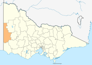
The Shire of West Wimmera is a local government area in the western part of the Wimmera region of Victoria, Australia, located in the western part of the state. It covers an area of 9,108 square kilometres (3,517 sq mi) and in June 2018 had a population of 3,862. It includes the towns of Apsley, Edenhope, Goroke, Gymbowen, Harrow, Kaniva, Minimay, Nurcoung and Serviceton. It was formed in 1995 from the amalgamation of the Shire of Kaniva and parts of the Shire of Kowree, Shire of Arapiles and Shire of Glenelg.

Stawell, is an Australian town in the Wimmera region of Victoria 237 kilometres (147 mi) west-north-west of the state capital, Melbourne. Located within the Shire of Northern Grampians local government area, it is a seat of local government for the shire and its main administrative centre. At the 2016 census, Stawell had a population of 6,032.

The Wimmera is a region of the Australian state of Victoria. The district is located within parts of the Loddon Mallee and the Grampians regions; and covers the dryland farming area south of the range of Mallee scrub, east of the South Australia border and north of the Great Dividing Range. It can also be defined as the land within the social catchment of Horsham, its main settlement.

Kaniva is a town in Victoria, Australia. It is located on the Western Highway, north of Little Desert National Park, in the Shire of West Wimmera local government area. It is located roughly 25 kilometres (16 mi) east of the South Australian border and 43 kilometres (27 mi) east of Bordertown. At the 2016 census, Kaniva had a population of 803. The town is commonly used as a rest point for those travelling between Melbourne and Adelaide. The Kaniva region has some rare flora and fauna. The rare south-eastern red-tailed black cockatoo is found in the region. The Shire of West Wimmera prohibits the felling of dead trees to ensure that they have adequate nesting sites.

Horsham is a regional city in the Wimmera region of western Victoria, Australia. Located on a bend in the Wimmera River, Horsham is approximately 300 kilometres (190 mi) northwest of the state capital Melbourne. In June 2018, Horsham had an estimated population of 16,514. It is the most populous city in Wimmera, and the main administrative centre for the Rural City of Horsham local government area. It is the eleventh largest city in Victoria after Melbourne, Geelong, Ballarat, Bendigo, Wodonga, Mildura, Shepparton, Warrnambool, Traralgon, and Wangaratta.

The Yarriambiack Creek, an inland intermittent watercourse of the Wimmera catchment, is located in the Wimmera region of the Australian state of Victoria. Rising on the northern slopes of the Great Dividing Range, the Yarriambiack Creek flows generally north and drains into Lake Coorong, one of a series of ephemeral lakes, northeast of Hopetoun.

The Division of Mallee is an Australian Electoral Division in the state of Victoria. It is located in the far north-west of the state, adjoining the border with South Australia in the west, and the Murray River in the north. At 81,962 square kilometres (31,646 sq mi), it is the largest Division in Victoria. It includes the centres of Mildura, Ouyen, Swan Hill, St Arnaud, Warracknabeal, Stawell, Horsham and Maryborough.
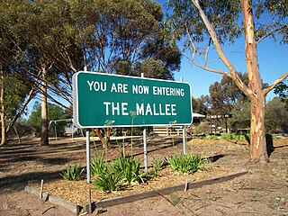
The Mallee covers the most northwesterly part of Victoria, bounded by the South Australian and New South Wales borders. Definitions of the south-eastern boundary vary, however, all are based on the historic Victorian distribution of mallee eucalypts. These trees dominate the surviving vegetation through most of Mallee,. Its biggest settlements are Mildura and Swan Hill.

Birchip is a town in the Mallee region of Victoria, Australia on the Sunraysia Highway north of Donald. The town is located in the Shire of Buloke local government area. At the 2016 census, Birchip had a population of 702, up from the 2011 figure of 662. It has a P-12 school, and an Australian rules football club called Birchip-Watchem, also known as the Birchip-Watchem Bulls, or just the "Bulls".

Minyip is a town in the Wimmera region of Victoria, Australia, 320 kilometres (199 mi) north west of Melbourne. It is in the Shire of Yarriambiack local government area. At the 2016 census, Minyip had a population of 524.

The Wimmera River, an inland intermittent river of the Wimmera catchment, is located in the Grampians and Wimmera regions of the Australian state of Victoria. Rising in the Pyrenees, on the northern slopes of the Great Dividing Range, the Wimmera River flows generally north by west and drains into Lake Hindmarsh and Lake Albacutya, a series of ephemeral lakes that, whilst they do not directly empty into a defined watercourse, form part of the Murray River catchment of the Murray-Darling basin.

The Shire of Warracknabeal was a local government area about 200 kilometres (124 mi) west-northwest of Bendigo and 60 kilometres (37 mi) north of Horsham in western Victoria, Australia. The shire covered an area of 1,839 square kilometres (710.0 sq mi), and existed from 1891 until 1995.

The City of Horsham was a local government area about 290 kilometres (180 mi) west-northwest of Melbourne, the state capital of Victoria, Australia. The city covered an area of 23.31 square kilometres (9.0 sq mi), and existed from 1882 until 1994.

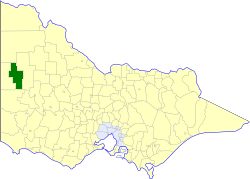
The Shire of Arapiles was a local government area in the Wimmera region of western Victoria, Australia. The shire covered an area of 2,342.62 square kilometres (904.5 sq mi), and existed from 1888 until 1995.
The Shire of Dimboola was a local government area in the Wimmera region of western Victoria, Australia. The shire covered an area of 4,856 square kilometres (1,874.9 sq mi), and existed from 1885 until 1995.

The Shire of Kaniva was a local government area in the Wimmera region of western Victoria, Australia, near the South Australian town of Bordertown. The shire covered an area of 3,082.11 square kilometres (1,190.0 sq mi), and existed from 1891 until 1995.
The Shire of Lowan was a local government area in the Wimmera region of western Victoria, Australia. The shire covered an area of 2,861 square kilometres (1,104.6 sq mi), and existed from 1875 until 1995.

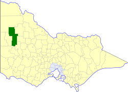
The Shire of Wimmera was a local government area in the Wimmera region of western Victoria, Australia. The shire covered an area of 2,611 square kilometres (1,008.1 sq mi), and existed from 1862 until 1995. Although its shire offices were located in Horsham, Horsham was governed by a separate city council.

The Avon River, an inland intermittent river of the Wimmera catchment, located in the Grampians and Wimmera regions of the Australian state of Victoria. Rising on the northern slopes of the Great Dividing Range, the Avon River flows north-westerly to reach its confluence with the Richardson River. The rivers of the Wimmera catchment drain into a series of ephemeral lakes that, whilst they do not directly empty into a defined watercourse, they form part of the Murray River catchment of the Murray-Darling basin.
The Mackenzie River, an inland intermittent river of the Wimmera catchment, is located in the Grampians region of the Australian state of Victoria. Rising in the Grampians National Park, on the northern slopes of the Great Dividing Range, the Mackenzie River flows generally north by west and drains into the Wimmera River, southwest of Horsham.
