
Bradfield is a civil parish in the City of Sheffield, in South Yorkshire, England.

Bentham is a civil parish in the Craven district of North Yorkshire, England, with a population of 3,027 at the 2011 Census. The parish includes the town of High Bentham, occasionally known as Higher Bentham or just Bentham, and the older adjacent village of Low Bentham.

Masham is a market town and civil parish in the Harrogate district of North Yorkshire, England. It had a population of 1,205 at the 2011 census.

A civil parish is a subnational entity, forming the lowest unit of local government in England. There are 219 civil parishes in the ceremonial county of Lancashire; Blackpool is completely unparished; Pendle and Ribble Valley are entirely parished. At the 2001 census, there were 587,074 people living in the 219 parishes, accounting for 41.5 per cent of the county's population.

A civil parish is a subnational entity, forming the lowest unit of local government in England. There are 101 civil parishes in the ceremonial county of West Yorkshire, most of the county being unparished. At the 2001 census, there were 557,369 people living in the parishes, accounting for 26.8 per cent of the county's population.

Brinkburn Priory is a former monastery built, starting in the 12th century, on a bend of the River Coquet, about 4 miles (6 km) east of Rothbury, Northumberland, England.

North East Somerset is a constituency represented in the House of Commons of the UK Parliament, since its 2010 creation, by Conservative Jacob Rees-Mogg.

Kennington is a suburb of Ashford and civil parish in Kent, England. It is about a mile northeast of the town centre and north of the M20 motorway, and contains the 12th-century church, St Mary's. The main A28 Canterbury Road and A2042 Faversham Road run through the village, and the A251 Trinity Road skirts the western edge. In recent years the village has expanded with the building of new housing estates in the Little Burton, Towers View and Conningbrook Park areas.
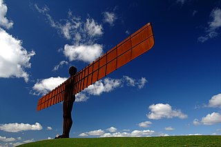
Lamesley is a village and civil parish in the Metropolitan Borough of Gateshead, Tyne and Wear, England. The population of the civil parish at the 2011 census was 3,742. The village is on the southern outskirts of Gateshead, near to Birtley. The parish includes Kibblesworth, Lamesley village, Eighton Banks and Northside, Birtley which is predominantly private housing in neighbourhoods named The Hollys, Long Bank, Northdene and Crathie. The ruined Ravensworth Castle is also in Lamesley.

Aighton, Bailey and Chaigley is a civil parish in the Borough of Ribble Valley in Lancashire, England, just west of Clitheroe. The population of the civil parish at the 2011 census was 1,307, an increase from 1,249 in 2001.

Hesket is a large civil parish in the Eden District of Cumbria, England, on the main A6 between Carlisle and Penrith. At the 2001 census it had a population of 2,363, increasing to 2,588 at the 2011 census, and estimated at 2,774 in 2019. The parish formed in 1894 with the passing of the Local Government Act 1894 and was enlarged to incorporate the parish of Plumpton Wall following a County Review Order in 1934. Hesket is part of the historic royal hunting ground of Inglewood Forest. Settlement in the parish dates back to the Roman occupation.

Stanwix Rural is a civil parish in the City of Carlisle district of Cumbria, England, immediately to the north east of Carlisle itself – parts of the Carlisle urban area are in the parish boundaries.

Hensingham is a suburb of Whitehaven and former civil parish, now in the parish of Whitehaven, in the Copeland district, in the county of Cumbria, England. The ward population taken at the 2011 census was 4,145. In 1931 the parish had a population of 2116.

Wye with Hinxhill is a hillside civil parish in the borough of Ashford northeast of Ashford, Kent itself, centred 3.7 miles NNE of the town centre. The North Downs range of hills has a high escarpment on the east and west borders of the village, flanking a gap caused by the River Great Stour in the centre of the parish.

Harrington is a village and former civil parish on the Cumbrian coast south of Workington and north of Whitehaven in England. Historically part of Cumberland, its industrial history, which largely ended in the late 1930s, included a shipbuilders, iron works, coal mining and steel making. It once had five railway stations. It still has one railway station, on the Cumbrian Coast Line, near the harbour.

Newsholme is a small village and civil parish in the Ribble Valley, Lancashire, England, but lies within the historic West Riding of Yorkshire. According to the 2001 census, the parish had a population of 50, however the United Kingdom Census 2011 grouped the parish with Horton and Paythorne, giving a total of 253. Today it lies near the boundary with North Yorkshire on the A682, 4 miles (6 km) north of Barnoldswick and 12 miles (19 km) west of Skipton.

Clee St. Margaret is a small village and civil parish in the Clee Hills area of Shropshire, England. It is seven miles north east from the market town of Ludlow.

Hesleyhurst is a civil parish in the county of Northumberland in England. At the 2011 Census the population was only minimal. It is served by a joint parish council with nearby Brinkburn.

High and Low Bishopside is a civil parish in Nidderdale in the Harrogate district, in the county of North Yorkshire, England. It includes the town of Pateley Bridge and the villages of Glasshouses and Wilsill, the southern part of Wath and the hamlets of Blazefield, and Fellbeck. The parish touches Bewerley, Dacre, Eavestone, Fountains Earth, Hartwith cum Winsley, Laverton, Sawley, Stonebeck Down and Warsill. In 2011 the parish had a population of 2,210. There are 39 listed buildings in High and Low Bishopside. The parish's council is called "Pateley Bridge Town Council".

