
Bristol is a town in Addison County, Vermont, United States. The town was chartered on June 26, 1762, by the colonial Governor of New Hampshire, Benning Wentworth. The charter was granted to Samuel Averill and sixty-three associates in the name of Pocock—in honor of a distinguished English admiral of that name. The population was 3,782 at the 2020 census. Main Street is home to most of the businesses of the town. The town is also home to the Lord's Prayer Rock.

Goshen is a town in Addison County, Vermont, United States. The population was 172 at the 2020 census.

Hancock is a town in Addison County, Vermont, United States. The town was named for John Hancock. The population was 359 at the 2020 census. Hancock is home to the Middlebury College Snow Bowl and contains Middlebury Gap through the Green Mountains.

Lincoln is a town in Addison County, Vermont, United States. Lincoln is located at the base of Mount Abraham in the Green Mountains. It was settled by Quakers in the late 18th Century. The population was 1,323 at the 2020 census. Today, Lincoln is known for its scenic, rural beauty and its proximity to two Vermont ski areas, Mad River Glen and Sugarbush.

New Haven is a town in Addison County, Vermont, United States. The population was 1,683 at the 2020 census. In addition to the town center, New Haven contains the communities of Belden, Brooksville, New Haven Junction and New Haven Mills.

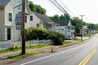
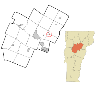
Starksboro is a town in Addison County, Vermont, United States. The population was 1,756 at the 2020 census.

Manchester Center is a census-designated place (CDP) in the town of Manchester in Bennington County, Vermont, United States. As of the 2010 census, the CDP had a population of 2,120, out of 4,391 people in the entire town of Manchester.

Burke is a town in Caledonia County, Vermont, United States. The population was 1,651 at the 2020 census. The town contains the villages of East Burke, West Burke and Burke Hollow. The town is home to Burke Mountain and Burke Mountain Academy.
Groton is a town in Caledonia County, Vermont, United States. The population was 984 at the 2020 census. It contains the places Groton Pond, Rickers Mills, Rickers and West Groton. The unincorporated village of Groton in the southeast corner of town is recorded as the Groton census-designated place (CDP), with a population of 419 at the 2020 census.

Morristown is a town in Lamoille County, Vermont, United States. As of the 2020 census, the population was 5,434. Morristown is the largest town by population in Lamoille County, and its central village of Morrisville serves as the county's main commercial center.

Waitsfield is a town in Washington County, Vermont, United States. The population was 1,844 as of the 2020 census. It was created by a Vermont charter on February 25, 1782, and was granted to militia Generals Benjamin Wait, Roger Enos and others. The town was named after Wait.

Milton is an unincorporated village within the town of Milton in Chittenden County, Vermont, United States. The village disincorporated in 2003 and became a census-designated place (CDP) in 2008. As of the 2020 census the population was 3,804, out of a population of 10,723 for the entire town.
West Rutland is the central village and a census-designated place (CDP) in the town of West Rutland, Rutland County, Vermont, United States. As of the 2020 census, it had a population of 1,898, out of 2,214 in the entire town of West Rutland.

Windsor is a census-designated place (CDP) comprising the main settlement within the town of Windsor, Windsor County, Vermont, United States. The population of the CDP was 2,066 at the 2010 census, compared with 3,553 for the town as a whole.

East Montpelier is a census-designated place (CDP) comprising the central village of the town of East Montpelier, Washington County, Vermont, United States. The population of the CDP was 80 at the 2010 census.
Plainfield is a census-designated place (CDP) comprising the main village of the town of Plainfield, Washington County, Vermont, United States. The population of the CDP was 401 at the 2010 census.

Richford is a census-designated place comprising the main settlement in the town of Richford, Franklin County, Vermont, United States. Its population was 1,361 as of the 2010 census, out of 2,308 people in the entire town of Richford.
Wilmington is the primary village and a census-designated place (CDP) in the town of Wilmington, Windham County, Vermont, United States. As of the 2020 census, it had a population of 439, compared to 2,255 in the entire town. The center of the village is part of the Wilmington Village Historic District.
Wardsboro is the primary village and a census-designated place (CDP) in the town of Wardsboro, Windham County, Vermont, United States. As of the 2020 census, it had a population of 70, compared to 869 in the entire town.


