
Pretoria is South Africa's administrative capital, serving as the seat of the executive branch of government, and as the host to all foreign embassies to South Africa.

Marthinus Wessel Pretorius was a South African political leader. An Afrikaner, he helped establish the South African Republic, was the first president of the ZAR, and also compiled its constitution.
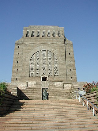
The Voortrekker Monument is located just south of Pretoria in South Africa. The granite structure is located on a hilltop, and was raised to commemorate the Voortrekkers who left the Cape Colony between 1835 and 1854. It was designed by the architect Gerard Moerdijk.

Potchefstroom, colloquially known as Potch, is an academic city in the North West Province of South Africa. It hosts the Potchefstroom Campus of the North-West University. Potchefstroom is on the Mooi Rivier, roughly 120 km (75 mi) west-southwest of Johannesburg and 45 km (28 mi) east-northeast of Klerksdorp.

The Weenen massacre was the massacre of Khoikhoi, Basuto and Voortrekkers by the Zulu Kingdom on 17 February 1838. The massacres occurred at Doringkop, Bloukrans River, Moordspruit, Rensburgspruit and other sites around the present day town of Weenen in South Africa's KwaZulu-Natal province.
Weenen is the second oldest European settlement in KwaZulu-Natal, South Africa. It is situated on the banks of the Bushman River. The farms around the town grow vegetables, lucerne, groundnuts, and citrus fruit.

Winburg is a small mixed farming town in the Free State province of South Africa.

Mokopane, also known as Potgietersrus, is a town in the Limpopo province of South Africa.
Fochville is a farming and mining town located in the Gauteng province of South Africa. It is part of the Merafong City Local Municipality, which also includes Kokosi, Carletonville and Khutsong. The area surrounding Fochville contains Sotho or Tswana ruins. Tlokwe Ruins are the remains of Sotho-Tswana settlements on the hills surrounding Fochville that were inhabited until the 1820s. Boer War hero Danie Theron was killed 5 km north of the town. The town itself was established as an agricultural centre in 1920 and was named after the World War I commander-in-chief of the Allied forces in France, Marshal of France Ferdinand Foch.
The R104 is a regional route in South Africa that is the designation for some of the old sections of roads that were previously the N4, prior to upgrading. It connects Pretoria with Middelburg in Mpumalanga via Bronkhorstspruit and Witbank. It also connects Pretoria with Rustenburg in the North West province via Hartbeespoort and Mooinooi.
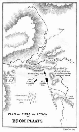
The Battle of Boomplaats was fought near Jagersfontein at 29°50′53.47″S25°38′56.54″E on 29 August 1848 between the British and the Voortrekkers. The British were led by Sir Harry Smith, while the Boers were led by Andries Pretorius. The British were victorious after one Boer opened fire too early and betrayed their position.

Stephanus Schoeman was President of the South African Republic from 6 December 1860 until 17 April 1862. His red hair, fiery temperament and vehement disputes with other Boer leaders earned him the moniker "Stormvogel den Noorden," "Storm bird of the North."

The Day of the Vow is a religious public holiday in South Africa. It is an important day for Afrikaners, originating from the Battle of Blood River on 16 December 1838, before which about 400 Voortrekkers made a promise to God that if He rescued them out of the hands of the approximately 20,000 Zulu warriors they were facing, they would honour that day as a sabbath day in remembrance of what God did for them.

The N4 is a national route in South Africa that runs from Skilpadshek on the Botswana border, past Rustenburg, Pretoria, eMalahleni and Mbombela, to Komatipoort on the Mozambique border. It forms the South African section of the Trans-Kalahari Corridor, which runs from Walvis Bay to Maputo, meaning that it links the east and west coasts of Southern Africa. Since the completion of the A2 through Botswana, the entire Corridor is now a world-class standard highway; it features at least one carriageway in each direction of high-speed traffic plus a paved shoulder for its entire length.
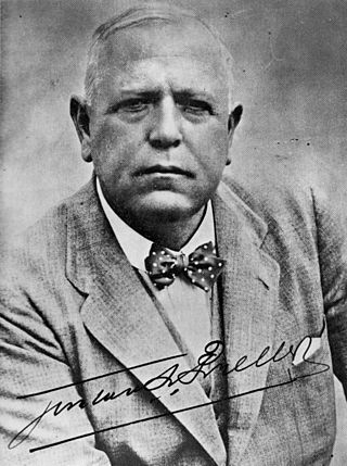
Gustav Schoeman Preller was a journalist, historian, writer and literary critic. He fought for the recognition of Afrikaans. Preller helped the Afrikaner to awake to the importance of the history of South Africa. He made great contributions to the writing of South African history, through his research and the literature. He also contributed greatly to making South Africans aware of the legacy of the Voortrekkers and also played an early part in planning the Voortrekker Monument.

The Zulu Kingdom, sometimes referred to as the Zulu Empire or the Kingdom of Zululand, was a monarchy in Southern Africa. During the 1810s, Shaka established a modern standing army that consolidated rival clans and built a large following which ruled a wide expanse of Southern Africa that extended along the coast of the Indian Ocean from the Tugela River in the south to the Pongola River in the north.
Safari World is a tourist attraction in Bangkok, Thailand that consists of two parks named Marine Park and Safari Park, operated by Safari World Public Limited. The park was opened in 1988 with a total area of 480 acres (190 ha) for its open zoo and 180 acres (73 ha) for its bird park. A major renovation to enhance effectiveness of land use began on 17 April 1989 and its total area developed for the leisure park now consists of an open zoo and a marine park on 500 rai of land.
The R511 is a Regional Route in South Africa that connects Sandton with Thabazimbi via Hartbeespoort and Brits.
The R512 is a Regional Route in South Africa that connects Brits, North West with Randburg, Gauteng via the western side of Hartbeespoort. It is an alternative route to the R511 for travel between the Johannesburg Metropole and Brits.
The R552 is a Regional Route in the City of Johannesburg Metropolitan Municipality in Gauteng, South Africa. It connects Lanseria International Airport with Fourways.


