Siyancuma Municipality is a local municipality within the Pixley ka Seme District Municipality, in the Northern Cape province of South Africa.

Mogale City Local Municipality is a local municipality within the West Rand District Municipality, in the Gauteng province of South Africa.

Thaba Chweu Municipality is a local municipality within the Ehlanzeni District Municipality, in the Mpumalanga province of South Africa.
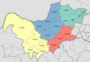
Makhado Municipality is a local municipality within the Vhembe District Municipality, in the Limpopo province of South Africa. The seat is Louis Trichardt.

Musina Municipality is a local municipality within the Vhembe District Municipality, in the Limpopo province of South Africa. It is the northernmost local municipality in South Africa. It borders Botswana, Mozambique and Zimbabwe. The seat is Musina.

Emakhazeni Municipality formerly Highlands Municipality, is a local municipality within the Nkangala District Municipality, in the Mpumalanga province of South Africa. The seat is Belfast.
Moses Kotane Municipality is a local municipality within the Bojanala Platinum District Municipality, in the North West province of South Africa. It is named in memory of Moses Kotane. The seat of the municipality is Mogwase.

The City of Matlosana, formerly the City Council of Klerksdorp, is a local municipality within the Dr Kenneth Kaunda District Municipality, in the North West province of South Africa.
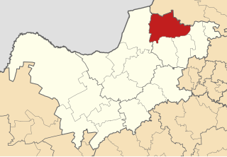
Naledi Municipality is a local municipality within the Dr Ruth Segomotsi Mompati District Municipality, in the North West province of South Africa. The seat of the municipality is Vryburg.
Lekwa-Teemane Municipality is a local municipality within the Dr Ruth Segomotsi Mompati District Municipality, located in the North West province of South Africa. The seat of the municipality is Christiana.

Metsimaholo Municipality is a local municipality within the Fezile Dabi District Municipality, in the Free State province of South Africa. Metsimaholo means "big water" in Sesotho.

Endumeni Municipality is a local municipality within the Umzinyathi District Municipality, in the KwaZulu-Natal province of South Africa. Endumeni is an isiZulu word meaning "a place of thunderstorm". The municipality shares its name with the Endumeni hill.

Kwa Sani Local Municipality was an administrative area in the Harry Gwala of KwaZulu-Natal in South Africa.

uMdoni Municipality is a local municipality within the Ugu District Municipality, in the KwaZulu-Natal province of South Africa. uMdoni is the isiZulu name for the indigenous forest waterberry plant.

Hantam Municipality is a local municipality within the Namakwa District Municipality, in the Northern Cape province of South Africa.

Letsemeng Municipality is a local municipality within the Xhariep District Municipality, in the Free State province of South Africa.

Inkwanca Local Municipality was a local municipality that forms part of the Chris Hani District Municipality in the Eastern Cape province of South Africa. Inkwanca is an isiXhosa name meaning cold. The municipal area is the coldest area in the country and the lowest temperatures are recorded in the area every year. After municipal elections on 3 August 2016 it was merged into the larger Enoch Mgijima Local Municipality.

uMuziwabantu Municipality is a local municipality within the Ugu District Municipality, in the KwaZulu-Natal province of South Africa. uMuziwabantu is an isiZulu word meaning "the people's home", or "a home with wide open doors where everyone is welcome". The main source of income for the area is derived from the municipality's extensive wattle, gum, pine and poplar plantations, and associated industries, including saw mills and furniture-making factories.

Ubuhlebezwe Municipality is a local municipality within the Harry Gwala District Municipality, in the KwaZulu-Natal province of South Africa. Ubuhlebezwe is an isiZulu word meaning "the beauty of the land". The name is derived from Alan Paton's novel, Cry, The Beloved Country.

JB Marks Municipality is a local municipality within the Dr Kenneth Kaunda District Municipality, in the North West province of South Africa. It was established after the August 2016 local elections by merging the Tlokwe and Ventersdorp municipalities.