Mamusa Local Municipality

Last updated

Mamusa
Mamusa CoA.png
Map of the North West with Mamusa highlighted.svg
Location in the North West
Country South Africa
Province North West
District Dr Ruth Segomotsi Mompati
Seat Schweizer-Reneke
Wards 8
Government
[1]
  Type Municipal council
  Mayor(ANC)
Area
  Total3,615 km2 (1,396 sq mi)
Population
 (2011) [2]
  Total60,355
  Density17/km2 (43/sq mi)
Racial makeup (2011)
[2]
   Black African 91.4%
   Coloured 2.2%
   Indian/Asian 0.5%
   White 5.5%
First languages (2011)
[2]
   Tswana 85.1%
   Afrikaans 7.2%
   Sotho 2.2%
   English 1.7%
  Other3.8%
Time zone UTC+2 (SAST)
Municipal codeNW393

Mamusa Municipality (Tswana : Mmasepala wa Mamusa) is a local municipality within the Dr Ruth Segomotsi Mompati District Municipality, in the North West province of South Africa. The seat of the municipality is Schweizer-Reneke.

Contents

Politics

The municipal council consists of sixteen members elected by mixed-member proportional representation. Eight are elected by first-past-the-post voting in eight wards, while the remaining eight are chosen from party lists so that the total number of party representatives is proportional to the number of votes received. In the election of 1 November 2021 the African National Congress (ANC) won a majority of nine seats on the council.

The following table shows the results of the 2021 election. [3]

PartyWardListTotal
seats
Votes%SeatsVotes%Seats
African National Congress 7,65154.4777,72556.5129
Economic Freedom Fighters 3,41424.3103,50125.6144
Freedom Front Plus 8906.3419126.6701
Azanian Independent Community Movement 8045.7208236.0211
Democratic Alliance 3962.8203752.7411
Independent candidates 6564.6700
5 other parties2341.6703352.4500
Total14,045100.00813,671100.00816
Valid votes14,04596.2513,67193.91
Invalid/blank votes5473.758876.09
Total votes14,592100.0014,558100.00
Registered voters/turnout28,10751.9228,10751.79

As of 2023, Mamusa Local Municipality has received disclaimed audits (the worst outcome) for eleven years in a row, the only municipality to do so. [4] [5]

Geography

The municipality covers an area of 3,615 square kilometres (1,396 sq mi) in the south-west part of North West province. At the time of the 2011 census it has a population of 60,355. According to the census, the predominant language in the municipality is Setswana, spoken by 85.1% of the population, followed by Afrikaans (7.2%), Sesotho (2.2%) and English (1.7%). 91.5% of the population identified as "Black African", 5.5% as "White", 2.2% as "Coloured", and 0.5% as "Indian or Asian". The 2016 Community Survey estimated that the population had increased to 64,000.

The principal town is Schweizer-Reneke, located in the centre of the municipality, which (including the township of Ipelegeng) had a population of 41,226 in 2011. Other settlements include Amalia (pop. 5,481) to the west, and Migdol (pop. 3,526) and Glaudina (pop. 2,368) to the north-east.

Roads radiate outwards from Schweizer-Reneke towards Vryburg, Delareyville, Wolmaransstad, Bloemhof, Christiana and Pudimoe. The road from Vryburg to Bloemhof is designated as provincial route R34, while the others are designated as regional routes R504 (Pudimoe–Wolmaransstad) and R506 (Christiana–Delareyville). The Coligny–Vermaas–Pudimoe railway line also passes through the municipality.

Related Research Articles

<span class="mw-page-title-main">Transvaal (province)</span> Former province of South Africa

The Province of the Transvaal, commonly referred to as the Transvaal, was a province of South Africa from 1910 until 1994, when a new constitution subdivided it following the end of apartheid. The name "Transvaal" refers to the province's geographical location to the north of the Vaal River. Its capital was Pretoria, which was also the country's executive capital.

<span class="mw-page-title-main">North West (South African province)</span> Province in South Africa

Schweizer-Reneke, sometimes referred to as Schweizer, is a town in the North West Province of South Africa. It is the administrative centre of Mamusa Local Municipality. It is commonly referred to as Schweizer/ Mzwera.

<span class="mw-page-title-main">Delareyville</span> Place in North West, South Africa

Delareyville is a maize- and peanut-farming town situated in North West Province of South Africa. The town is 96 km south-west of Lichtenburg, 82 km north-east of Vryburg, 114 km north-west of Wolmaransstad, and 61 km north of Schweizer-Reneke.

<span class="mw-page-title-main">Wolmaransstad</span> Place in North West, South Africa

Wolmaransstad is a maize-farming town situated on the N12 between Johannesburg and Kimberley in North West Province of South Africa. The town lies in an important alluvial diamond-mining area and it is the main town of the Maquassi Hills Local Municipality.

<span class="mw-page-title-main">R34 (South Africa)</span> Road in South Africa

The R34 is a long provincial route in South Africa that connects Vryburg with Richards Bay via Kroonstad and Newcastle. It passes through three provinces, North West, the Free State and KwaZulu-Natal.

<span class="mw-page-title-main">Magistrate's court (South Africa)</span> Court of first instance in South Africa

The magistrates' courts are the lowest level of the court system in South Africa. They are the courts of first instance for most criminal cases except for the most serious crimes, and for civil cases where the value of the claim is below a fixed monetary limit.

<span class="mw-page-title-main">Tswaing Local Municipality</span> Local municipality in North West, South Africa

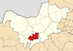
Tswaing Municipality is a local municipality within the Ngaka Modiri Molema District Municipality, in the North West province of South Africa. It consists of the towns of Delareyville, Sannieshof and Ottosdal.
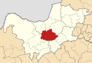
Pudimoe or Pudumong is a town in Dr Ruth Segomotsi Mompati District Municipality in the North West province of South Africa.

The R504 is a Regional Route in South Africa that connects Pudimoe with Bothaville via Amalia, Schweizer-Reneke, Wolmaransstad and Leeudoringstad.

The R506 is a Regional Route in South Africa.

Ipelegeng is a township west of Schweizer-Reneke in the Mamusa Local Municipality, in the North West Province of South Africa. The total population of the township is about 32,090 people. About 90% of the people in the area are Tswana people. It is located 5 km west of Schweizer-Reneke and 30 km east of Amalia, along the R504.

<span class="mw-page-title-main">Bloemhof Commando</span> Military unit

Bloemhof Commando was a light infantry regiment of the South African Army. It formed part of the South African Army Infantry Formation as well as the South African Territorial Reserve.

<span class="mw-page-title-main">Christiana Commando</span> Military unit

Christiana Commando was a light infantry regiment of the South African Army. It formed part of the South African Army Infantry Formation as well as the South African Territorial Reserve.

<span class="mw-page-title-main">Delareyville Commando</span> Military unit

Delareyville Commando was a light infantry regiment of the South African Army. It formed part of the South African Army Infantry Formation as well as the South African Territorial Reserve.

<span class="mw-page-title-main">Stellaland Commando</span> Military unit

Stellaland Commando was a light infantry regiment of the South African Army. It formed part of the South African Army Infantry Formation as well as the South African Territorial Reserve.

<span class="mw-page-title-main">Schweizer Reineke Commando</span> Military unit

Schweizer Reneke Commando was a light infantry regiment of the South African Army. It formed part of the South African Army Infantry Formation as well as the South African Territorial Reserve.

<span class="mw-page-title-main">Kalahari Commando</span> Military unit

Kalahari Commando was a light infantry regiment of the South African Army. It formed part of the South African Army Infantry Formation as well as the South African Territorial Reserve.

Mapule Veronica Mafolo is a South African former politician and convicted criminal who served as a Member of the National Assembly of South Africa from 2009 to 2019, representing the African National Congress.

References

  1. "Contact list: Executive Mayors". Government Communication & Information System. Archived from the original on 14 July 2010. Retrieved 22 February 2012.
  2. 1 2 3 "Statistics by place". Statistics South Africa. Retrieved 27 September 2015.
  3. "Election Result Table for LGE2021 — Mamusa". wikitable.frith.dev. Retrieved 4 December 2021.
  4. "11 years of municipal audits". tools.theoutlier.co.za. Retrieved 22 February 2023.
  5. "Mamusa Local Municipality in North West got disclaimed audits (the worst opinion) for 11 years in a row". Twitter. Retrieved 22 February 2023.

27°15′S25°15′E / 27.250°S 25.250°E / -27.250; 25.250