
Malmesbury Abbey, at Malmesbury in Wiltshire, England, is a former Benedictine abbey dedicated to Saint Peter and Saint Paul. It was one of the few English religious houses with a continuous history from the 7th century through to the Dissolution of the Monasteries.

Alton is a civil parish in Wiltshire, England. The parish includes the adjacent villages of Alton Barnes and Alton Priors, and the nearby hamlet of Honeystreet on the Kennet and Avon Canal. It lies in the Vale of Pewsey about 6 miles (10 km) east of Devizes.
Baydon is a village and civil parish in Wiltshire, England about 10 miles (16 km) south-east of Swindon. The eastern boundary of the parish forms part of the county boundary with Berkshire, and the village is about 7 miles (11 km) north-west of the West Berkshire market town of Hungerford.

Sherston is a village and civil parish about 5 miles (8 km) west of Malmesbury in Wiltshire, England. The parish is bounded to the north by the county boundary with Gloucestershire, and to the southeast by the Fosse Way, a Roman road. The parish includes the hamlets of Easton Town, immediately east of Sherston; Pinkney, further east along the Malmesbury road; and Willesley, to the north.

Kington Langley is a village and civil parish about 2 miles (3.2 km) north of Chippenham in Wiltshire, England. The parish includes the hamlet of Bowldown.

Manton is a suburb of the town of Marlborough in Wiltshire, England, just off the A4 Bath Road.

Bremhill is a village and civil parish in Wiltshire, England. The village is about 1.6 miles (2.6 km) northwest of Calne and 4 miles (6.4 km) east of Chippenham. The name originates from 'Bramble hill'. In 2021 the parish had a population of 967.

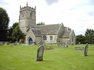
Lea is a village in Wiltshire, England, lying approximately 1.5 miles (2.4 km) east of Malmesbury. It is part of the civil parish of Lea and Cleverton which includes the village of Garsdon and the hamlet of Cleverton. Garsdon was a separate parish until 1934.

Hullavington is a village and civil parish in Wiltshire, England, just to the north of the M4 motorway. The village lies about 4 miles (6 km) southwest of Malmesbury and 5+1⁄2 miles (9 km) north of Chippenham.

Ogbourne St George is a village and civil parish on the River Og about 3 miles (4.8 km) north of Marlborough, Wiltshire, England.

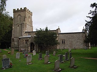
Charlton is a village and civil parish in North Wiltshire, England, about 2 miles (3 km) northeast of Malmesbury and 4 miles (6.4 km) northwest of the village of Brinkworth. The parish includes the hamlet of Perry Green and the Charlton Park estate. The 2011 Census recorded the parish population as 425.
Corston is a small village on the A429 road in Wiltshire, England, in the civil parish of St Paul Malmesbury Without, approximately 3 miles (4.8 km) south of the town of Malmesbury. The Gauze Brook, a tributary of the Bristol Avon, passes through the village.
Oaksey is a village and civil parish in Wiltshire, England, on the county boundary with Gloucestershire. The village is about 6 kilometres (3.7 mi) northeast of the market town of Malmesbury and a similar distance south south west of the Gloucestershire market town of Cirencester.

Manningford is a civil parish in Wiltshire, England. The parish includes the villages of Manningford Abbots, Manningford Bohune and Manningford Bruce, and the hamlet of Manningford Bohune Common, together known as the Manningfords.
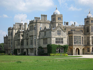
Charlton Park is a country house and estate in Wiltshire, England, 2 miles (3.2 km) northeast of the town of Malmesbury. Charlton Park House is a Grade I listed building and a leading example of the prodigy house.

Malmesbury is a town and civil parish in north Wiltshire, England, which lies approximately 14 miles (23 km) west of Swindon, 25 miles (40 km) northeast of Bristol, and 9 miles (14 km) north of Chippenham. The older part of the town is on a hilltop which is almost surrounded by the upper waters of the Bristol Avon and one of its tributaries.

Inglesham is a small village and civil parish in the Borough of Swindon, Wiltshire, England, notable for the Grade-I listed St John the Baptist Church. The village is just off the A361 road about 1 mile (1.6 km) south-west of Lechlade in Gloucestershire. Most of the population lives in the hamlet of Upper Inglesham, which is on the main road about 1.3 miles (2 km) south of the village.

Crudwell is a village and civil parish in north Wiltshire, England. The nearest towns are Malmesbury, about 4 miles (6.4 km) to the south-west, and Cirencester, Gloucestershire 8 miles (13 km) to the north-east. Also to the north-east is Cotswold Airport. Kemble village, about 4 miles (6.4 km) away, has the nearest railway station, with services to London Paddington and Gloucester.
Hankerton is a village and civil parish in Wiltshire, England, 3 miles (4.8 km) northeast of Malmesbury. The parish includes the hamlets of Cloatley, Cloatley End and Bullock's Horn.
St Paul Malmesbury Without is a civil parish surrounding Malmesbury, Wiltshire, England. Its main settlements are the village of Corston and the hamlets of Milbourne and Rodbourne.


