
Rutland County is a county located in the U.S. state of Vermont. As of the 2020 census, the population was 60,572, making it the second-most populous county in Vermont. Its county seat and most populous municipality is the city of Rutland.
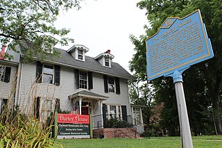
Claymont is a census-designated place (CDP) in New Castle County, Delaware. As of the 2020 U.S. census, the population of Claymont was 9,895.
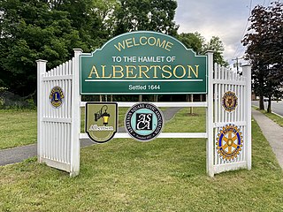
Albertson is a hamlet and census-designated place (CDP) in the Town of North Hempstead in Nassau County, on Long Island, in New York, United States. The population was 5,220 at the time of the 2020 census.

North Hempstead is one of three towns in Nassau County, on Long Island, in New York, United States. The population was 237,639 at the time of the 2020 census. It is the 7th largest city or town in New York by population.

Schodack is a town in Rensselaer County, New York, United States. The population was 12,965 at the 2020 census. The town name is derived from the Mahican word, Escotak. The town is in the southwestern part of the county. Schodack is southeast of Albany, New York.

Castleton is a town in Rutland County, Vermont, United States. Castleton is about 15 miles (24 km) to the west of Rutland, the county's seat and most populous city, and about 7 miles (11 km) east of the New York/Vermont state border. The town had a population of 4,458 at the 2020 census. Castleton University is located there, with roots dating to 1787.

Lancaster is a town in Erie County, New York, United States, centered 14 miles east of downtown Buffalo. Lancaster is an outer ring suburb of Buffalo. As of the 2020 Census, the town population was 45,106.

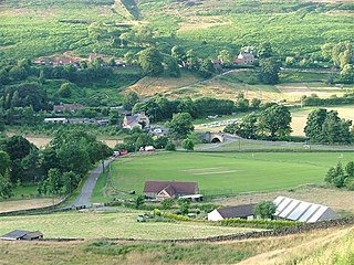
Castleton is a village in the High Peak district of Derbyshire, England, at the western end of the Hope Valley on the Peakshole Water, a tributary of the River Noe, between the Dark Peak to the north and the White Peak to the south. The population was 642 at the 2011 Census.

New York State Route 97 (NY 97) is a 70.53-mile-long (113.51 km) north–south scenic route in southern New York in the United States. It runs from U.S. Route 6 (US 6) and US 209 in Port Jervis to NY 17 in Hancock. Its most famous feature is the Hawk's Nest, a tightly winding section of the road along the Delaware River, located a few miles north of Port Jervis. NY 97 intersects NY 52 in Narrowsburg and indirectly connects to three Pennsylvania state highways due to its proximity to the state line.

The Limestone Way is a waymarked long-distance footpath in Derbyshire, England. It runs for 46 miles (74 km) through the White Peak of the Peak District National Park, from Castleton south to Rocester over the county boundary into Staffordshire. The trail is named for the limestone scenery along its route. It was devised by Brian Spencer of Matlock Rotary Club and developed and opened in 1986 by the West Derbyshire District Council. It originally ran to Matlock, but was extended to its current, longer route in 1992 to join up with the Staffordshire Way.
Castleton is a village on the River Esk, part of the civil parish of Danby in the county of North Yorkshire in England. It can be found 7.1 miles (11.5 km) south-east of Guisborough, in the North York Moors. There was once a medieval castle sited on Castle Hill that is thought to have been abandoned when Danby Castle was constructed.

Maryland Route 14 is a state highway in the U.S. state of Maryland. The state highway runs 11.51 miles (18.52 km) from MD 16 near Secretary east to MD 313 in Eldorado. MD 14 connects those two towns with the towns of East New Market and Brookview in northern Dorchester County. The state highway also shares a concurrency with MD 331 between the communities of Rhodesdale and Shiloh Church. The sections of MD 14 between East New Market and Eldorado were constructed between 1911 and 1914. The highway through Secretary was constructed in the late 1920s. The portion of MD 14 east of Shiloh Church was first marked as part of U.S. Route 213 in 1927. In the early 1930s, US 213 was rerouted through Vienna; as a result, MD 14 was extended to its present eastern terminus in Eldorado.

New York State Route 387 (NY 387) is a 2.95-mile (4.75 km) state highway located within the town of Murray in Orleans County, New York, in the United States. It serves as a north–south connector between NY 31 in the hamlet of Fancher and NY 104 midway between the hamlets of East Gaines and Murray. In between, NY 387 crosses the Erie Canal and passes through the community of Brockville. The route was assigned to its current alignment as part of the 1930 renumbering of state highways in New York.

Castleton is a hamlet in the city of Newport, South Wales.

New York State Route 9J (NY 9J) is a north–south state highway in the Hudson Valley region of New York in the United States. It begins at an intersection with US 9 in the Columbia County town of Stockport and extends for 22.35 miles (35.97 km) to an interchange with US 9 and US 20 in the Rensselaer County city of Rensselaer. The route parallels the Hudson River for its entire length, and several parts of the highway run directly alongside the river. NY 9J was assigned to its current alignment as part of the 1930 renumbering of state highways in New York.

New York State Route 150 (NY 150) is a north–south state highway in Rensselaer County, New York, in the United States. The southern terminus of the route is at NY 9J in Castleton-on-Hudson. Its northern terminus is at a junction with NY 66 in the hamlet of Wynantskill, located within the town of North Greenbush.

New York State Route 418 (NY 418) is a 3.50-mile (5.63 km) state highway located entirely within the Adirondack Park in Warren County, New York, in the United States. The route begins just west of the hamlet of Thurman Station, where Athol Road changes designations from County Route 4 (CR 4) to NY 418. It heads eastward through the towns of Thurman and Warrensburg, following the Schroon River to an intersection with U.S. Route 9 (US 9) in the hamlet of Warrensburg. All of NY 418 is part of the Dude Ranch Trail, a New York State Scenic Byway that runs through Warren County and Saratoga County.

Wolcottsburg is a hamlet in the town of Clarence in Erie County, New York, United States.

Maryland Route 623 is a state highway in the U.S. state of Maryland. The state highway runs 7.26 miles (11.68 km) from MD 161 in Darlington north to State Route 2043 at the Pennsylvania state line in Flintville. The first section of MD 623 was constructed in the mid-1930s south from the state line. The state highway was extended south to Darlington in two segments in the 1950s.

Castleton is the primary village and a census-designated place (CDP) in the town of Castleton, Rutland County, Vermont, United States. As of the 2020 census, it had a population of 1,337, out of 4,458 in the entire town. A large portion of the village is part of the Castleton Village Historic District, listed on the National Register of Historic Places in 1979. It is also home to Castleton University, founded in 1787, and now part of the Vermont State Colleges system.

