Buckhead Ridge, Florida

Last updated

Buckhead Ridge, Florida
CDP
Glades County Florida Incorporated and Unincorporated areas Buckhead Ridge Highlighted.svg
Location in Glades County and the state of Florida
Coordinates: 27°7′51″N80°53′28″W / 27.13083°N 80.89111°W / 27.13083; -80.89111
Country Flag of the United States.svg  United States
State Flag of Florida.svg  Florida
County   Glades
Area
[1]
  Total1.51 sq mi (3.92 km2)
  Land1.40 sq mi (3.63 km2)
  Water0.11 sq mi (0.29 km2)
Elevation
13 ft (4 m)
Population
 (2020)
  Total1,509
  Density1,076.32/sq mi (415.63/km2)
Time zone UTC-5 (Eastern (EST))
  Summer (DST) UTC-4 (EDT)
ZIP code
34974 [2]
Area code 863
FIPS code 12-09315 [3]
GNIS feature ID0279598 [4]

Buckhead Ridge is a census-designated place (CDP) in Glades County, Florida, United States. The population was 1,450 at the 2010 census. The community consists of a few small commercial developments and a large mobile home park. Most residential lots in the community abut canals that feed into Lake Okeechobee.

Contents

Geography

Buckhead Ridge is located at 27°7′51″N80°53′28″W / 27.13083°N 80.89111°W / 27.13083; -80.89111 (27.130819, -80.891041). [5]

According to the United States Census Bureau, the CDP has a total area of 1.4 square miles (3.6 km2), of which, 1.3 square miles (3.4 km2) of it is land and 0.1 square miles (0.26 km2) of it (7.09%) is water.

Demographics

Historical population
CensusPop.Note
2020 1,509
U.S. Decennial Census [6]

As of the census [3] of 2000, there were 1,390 people, 694 households, and 465 families residing in the CDP. The population density was 1,066.3 inhabitants per square mile (411.7/km2). There were 1,149 housing units at an average density of 881.4 per square mile (340.3/km2). The racial makeup of the CDP was 98.35% White, 0.14% African American, 0.07% Native American, 0.07% Asian, 0.14% from other races, and 1.22% from two or more races. Hispanic or Latino of any race were 0.94% of the population.

There were 694 households, out of which 8.9% had children under the age of 18 living with them, 57.8% were married couples living together, 5.5% had a female householder with no husband present, and 32.9% were non-families. 26.1% of all households were made up of individuals, and 18.2% had someone living alone who was 65 years of age or older. The average household size was 2.00 and the average family size was 2.33.

In the CDP, the population was spread out, with 9.9% under the age of 18, 3.5% from 18 to 24, 12.3% from 25 to 44, 31.2% from 45 to 64, and 43.2% who were 65 years of age or older. The median age was 62 years. For every 100 females, there were 102.9 males. For every 100 females age 18 and over, there were 98.6 males.

The median income for a household in the CDP was $26,406, and the median income for a family was $28,047. Males had a median income of $36,563 versus $25,726 for females. The per capita income for the CDP was $16,475. About 13.5% of families and 19.4% of the population were below the poverty line, including 29.0% of those under age 18 and 18.2% of those age 65 or over.

Related Research Articles

<span class="mw-page-title-main">Phoenix Lake-Cedar Ridge, California</span> Unincorporated community in California, United States

Phoenix Lake-Cedar Ridge is an unincorporated community and a former census-designated place (CDP) in Tuolumne County, California, United States. The population was 5,108 at the 2000 census.

<span class="mw-page-title-main">Black Diamond, Florida</span> Census-designated place in Florida, US

Black Diamond is a census-designated place (CDP) in Citrus County, Florida, United States. The population was 1,101 at the 2010 census, up from 694 in 2000.

<span class="mw-page-title-main">Lely, Florida</span> Census-designated place in Florida

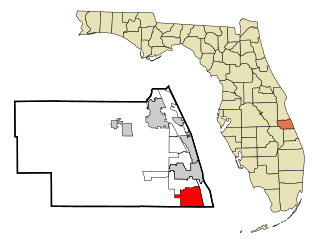
Lely is a census-designated place (CDP) in Collier County, Florida, United States. The population was 3,451 at the 2010 census. It is part of the Naples–Marco Island Metropolitan Statistical Area.

<span class="mw-page-title-main">Florida Ridge, Florida</span> CDP in Florida, United States

Florida Ridge is a census-designated place (CDP) in Indian River County, Florida, United States. The population was 18,164 at the 2010 census.

<span class="mw-page-title-main">Ridge Wood Heights, Florida</span> Census-designated place in Florida, United States

Ridge Wood Heights is a census-designated place (CDP) in Sarasota County, Florida, United States. The population was 4,795 at the 2010 United States Census. It is part of the Bradenton–Sarasota–Venice Metropolitan Statistical Area.

<span class="mw-page-title-main">Vinings, Georgia</span> CDP in Georgia, United States

Vinings is a census-designated place (CDP) in Cobb County, Georgia, United States that runs along the Chattahoochee River bank across from Buckhead. As of the 2020 census, the CDP had a total population of 12,581. Located next to the affluent Paces section of Buckhead in northwest Atlanta, Vinings is known for its historic sites, shopping districts, proximity to local freeways and The Battery, and nearby nature areas. The United States Postal Service assigns "Atlanta" to the ZIP Code (30339) that includes Vinings.

<span class="mw-page-title-main">Monument Beach, Massachusetts</span> Census-designated place in Massachusetts, United States

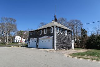
Monument Beach is a census-designated place (CDP) in the town of Bourne in Barnstable County, Massachusetts, United States. The population was 2,790 at the 2010 census.

<span class="mw-page-title-main">Heathcote, New Jersey</span> Populated place in Middlesex County, New Jersey, US

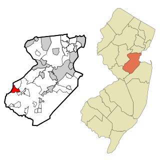
Heathcote is an unincorporated community and census-designated place (CDP) located within South Brunswick, in Middlesex County, in the U.S. state of New Jersey. As of the 2010 United States Census, the CDP's population was 5,821.

<span class="mw-page-title-main">Silver Ridge, New Jersey</span> Populated place in Ocean County, New Jersey, US

Silver Ridge is an unincorporated community and census-designated place (CDP) located within Berkeley Township, in Ocean County, in the U.S. state of New Jersey. As of the 2010 United States Census, the CDP's population was 1,133.

<span class="mw-page-title-main">North Patchogue, New York</span> Hamlet and census-designated place in New York, United States

North Patchogue is a hamlet and census-designated place (CDP) located within the Town of Brookhaven, in Suffolk County, New York, United States. The CDP population was 7,246 at the 2010 census.

<span class="mw-page-title-main">Scotts Corners, New York</span> CDP in New York, United States

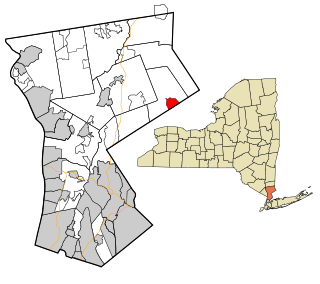
Scotts Corners is a hamlet located in the town of Pound Ridge in Westchester County, New York, United States. As of the 2010 census, the CDP population was 711, making Scotts Corners Westchester County's smallest census-recognized area.

Spring Ridge is a census-designated place (CDP) in Spring Township, Berks County, Pennsylvania, United States. The population was 1,003 at the 2010 census.

<span class="mw-page-title-main">Madisonburg, Pennsylvania</span> Census designated place in Pennsylvania, United States

Madisonburg is an unincorporated community and census-designated place (CDP) in Miles Township, Centre County, Pennsylvania, United States. It is part of the State College, Pennsylvania Metropolitan Statistical Area. The population was 168 at the 2010 census.

<span class="mw-page-title-main">Lime Ridge, Pennsylvania</span> Census-designated place in Pennsylvania, United States

Lime Ridge is a census-designated place (CDP) in Columbia County, Pennsylvania, United States. It is part of Northeastern Pennsylvania. The population was 890 at the 2010 census. It is part of the Bloomsburg-Berwick micropolitan area.

<span class="mw-page-title-main">New Castle Northwest, Pennsylvania</span> Census-designated place in Pennsylvania, United States

New Castle Northwest is an unincorporated area and census-designated place (CDP) in Lawrence County, Pennsylvania, United States. The population was 1,413 at the 2010 census.

<span class="mw-page-title-main">Pine Ridge, South Dakota</span> CDP in South Dakota, United States

Pine Ridge is a census-designated place (CDP) and the most populous community in Oglala Lakota County, South Dakota, United States. The population was 3,138 at the 2020 census. It is the tribal headquarters of the Oglala Sioux Tribe on the Pine Ridge Indian Reservation.

<span class="mw-page-title-main">Pea Ridge, West Virginia</span> Census-designated place in West Virginia, United States

Pea Ridge is a census-designated place in Cabell County, West Virginia, United States. As of the 2020 census, the population was 6,602. It is part of the Huntington–Ashland metropolitan area.

<span class="mw-page-title-main">Mineral Ridge, Ohio</span> Census-designated place in Ohio, United States

Mineral Ridge is an unincorporated community and census-designated place in southern Trumbull and northern Mahoning counties in the U.S. state of Ohio. The population was 3,951 at the 2020 census. It is a suburb of the Youngstown–Warren metropolitan area. Mineral Ridge was named for valuable coal deposits near the original town site.

<span class="mw-page-title-main">Meredith (CDP), New Hampshire</span> Census-designated place in New Hampshire, United States

Meredith is a census-designated place (CDP) and the main village in the town of Meredith in Belknap County, New Hampshire, United States. The population was 2,527 at the 2020 census, out of 6,662 in the entire town of Meredith.

Yorkshire is a census-designated place (CDP) in the northeastern corner of the town of Yorkshire in Cattaraugus County, New York, United States. The population of the CDP was 1,180 at the 2010 census, out of 3,913 in the town of Yorkshire as a whole.

References

  1. "2020 U.S. Gazetteer Files". United States Census Bureau. Retrieved October 31, 2021.
  2. "Buckhead Ridge FL ZIP Code". zipdatamaps.com. 2023. Retrieved February 17, 2023.
  3. 1 2 "U.S. Census website". United States Census Bureau . Retrieved January 31, 2008.
  4. "US Board on Geographic Names". United States Geological Survey. October 25, 2007. Retrieved January 31, 2008.
  5. "US Gazetteer files: 2010, 2000, and 1990". United States Census Bureau. February 12, 2011. Retrieved April 23, 2011.
  6. "Census of Population and Housing". Census.gov. Retrieved June 4, 2016.