Buffalo, South Carolina

Last updated

Buffalo, South Carolina
CDP
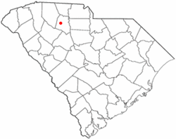
SCMap-doton-Buffalo.PNG
Location of Buffalo, South Carolina
Coordinates: 34°43′23″N81°40′39″W / 34.72306°N 81.67750°W / 34.72306; -81.67750
Country United States
State South Carolina
County Union
Area
[1]
  Total4.02 sq mi (10.42 km2)
  Land4.02 sq mi (10.42 km2)
  Water0.00 sq mi (0.00 km2)
Elevation
[2]
591 ft (180 m)
Population
 (2020) [3]
  Total1,288
  Density320.24/sq mi (123.66/km2)
Time zone UTC-5 (Eastern (EST))
  Summer (DST) UTC-4 (EDT)
ZIP code
29321
Area code 864
FIPS code 45-10090 [4]
GNIS feature ID1231101 [2]

Buffalo is a census-designated place (CDP) in Union County, South Carolina, United States. The population was 1,266 at the 2010 United States Census.

Contents

History

The community was named for a nearby mineral lick which attracted buffalo. [5]

The Buffalo Mill Historic District was added to the National Register of Historic Places in 1990. [6]

Geography

Buffalo is located at 34°43′23″N81°40′39″W / 34.723115°N 81.677454°W / 34.723115; -81.677454 . [7]

According to the United States Census Bureau, the CDP has a total area of 4.0 square miles (10 km2), all of it land.

Demographics

Historical population
CensusPop.Note
2020 1,288
U.S. Decennial Census [8]

As of the census [4] of 2000, there were 1,426 people, 587 households, and 402 families residing in the CDP. The population density was 355.2 inhabitants per square mile (137.1/km2). There were 659 housing units at an average density of 164.2 per square mile (63.4/km2). The racial makeup of the CDP was 83.03% White, 15.36% African American, 0.07% Native American, 0.35% Asian, 0.28% Pacific Islander, 0.42% from other races, and 0.49% from two or more races. Hispanic or Latino of any race were 1.26% of the population.

There were 587 households, out of which 28.1% had children under the age of 18 living with them, 47.4% were married couples living together, 14.7% had a female householder with no husband present, and 31.5% were non-families. 27.6% of all households were made up of individuals, and 11.2% had someone living alone who was 65 years of age or older. The average household size was 2.43 and the average family size was 2.94.

In the CDP, the population was spread out, with 23.6% under the age of 18, 8.3% from 18 to 24, 26.6% from 25 to 44, 25.7% from 45 to 64, and 15.8% who were 65 years of age or older. The median age was 39 years. For every 100 females, there were 83.5 males. For every 100 females age 18 and over, there were 85.8 males.

The median income for a household in the CDP was $36,285, and the median income for a family was $38,438. Males had a median income of $27,159 versus $19,286 for females. The per capita income for the CDP was $13,545. About 7.4% of families and 10.4% of the population were below the poverty line, including 13.9% of those under age 18 and none of those age 65 or over.

Related Research Articles

<span class="mw-page-title-main">Raisin City, California</span> Census-designated place in California, United States

Raisin City is a census-designated place (CDP) in Fresno County, California, United States. The population was 380 at the 2010 census, up from 165 at the 2000 census. Raisin City is located 13 miles (21 km) south-southwest of downtown Fresno, at an elevation of 236 feet.

<span class="mw-page-title-main">Hamilton Branch, California</span> Census-designated place in California, United States

Hamilton Branch is a census-designated place (CDP) in Plumas County, California, United States. The population was 587 at the 2000 census.

<span class="mw-page-title-main">Buckingham, Florida</span> Census-designated place in Florida, United States

Buckingham is an unincorporated community and census-designated place (CDP) in Lee County, Florida, United States. The population was 4,443 at the 2020 census, up from 4,036 at the 2010 census. It is part of the Cape Coral-Fort Myers, Florida Metropolitan Statistical Area.

<span class="mw-page-title-main">South Weldon, North Carolina</span> Census-designated place in North Carolina, United States

South Weldon is an unincorporated community and census-designated place (CDP) in Halifax County, North Carolina, United States. As of the 2010 census, the CDP population was 705. It is part of the Roanoke Rapids, North Carolina Micropolitan Statistical Area.

Fort McKinley is an unincorporated community in Harrison Township in Montgomery County, Ohio, United States. It was delineated as a census-designated place (CDP) at the 2000 census, when its population was 3,989. It was not delineated as a CDP for the 2010 census.

<span class="mw-page-title-main">Pleasant Grove, Ohio</span> CDP in Ohio, United States

Pleasant Grove is a census-designated place (CDP) in Muskingum County, Ohio, United States. The population was 2,016 at the 2000 census.

<span class="mw-page-title-main">Perry Heights, Ohio</span> CDP in Ohio, United States

Perry Heights is a census-designated place (CDP) in Stark County, Ohio, United States. The population was 8,900 at the 2000 census. It is part of the Canton-Massillon, OH Metropolitan Statistical Area. It was originally known as Genoa.

<span class="mw-page-title-main">Richboro, Pennsylvania</span> Census-designated place in Pennsylvania, United States

Richboro is a census-designated place (CDP) in Northampton Township, Bucks County, Pennsylvania, United States. The population was 6,378 during the 2020 census.

<span class="mw-page-title-main">Evansburg, Pennsylvania</span> Census-designated place in Pennsylvania, United States

Evansburg is a census-designated place (CDP) in Montgomery County, Pennsylvania, United States. The population was 2,129 at the 2010 census. It is a section of Lower Providence Township and is the namesake of Evansburg State Park.

<span class="mw-page-title-main">Thompsonville, Pennsylvania</span> Census-designated place in Pennsylvania, United States

Thompsonville is a census-designated place (CDP) in Washington County, Pennsylvania, United States. The population was 3,520 at the 2010 census.

<span class="mw-page-title-main">Spry, Pennsylvania</span> CDP in Pennsylvania, United States

Spry is a census-designated place (CDP) that is located in York County, Pennsylvania, United States. The population was 4,891 at the time of the 2010 census.

<span class="mw-page-title-main">Gloverville, South Carolina</span> Census-designated place in South Carolina, United States of America

Gloverville is a census-designated place (CDP) in Aiken County, South Carolina, United States. The population was 2,831 at the 2010 census. It is part of the Augusta, Georgia metropolitan area. Gloverville is located in historic Horse Creek Valley.

<span class="mw-page-title-main">Socastee, South Carolina</span> CDP in South Carolina, United States

Socastee is a census-designated place (CDP) in Horry County, South Carolina, United States. The population was 19,952 at the 2010 census.

<span class="mw-page-title-main">St. Andrews, South Carolina</span> Census-designated place in South Carolina, United States

St. Andrews is a census-designated place (CDP) in Richland County, South Carolina, United States. The population was 20,493 at the 2010 census. It is part of the Columbia, South Carolina Metropolitan Statistical Area.

<span class="mw-page-title-main">Saxon, South Carolina</span> CDP in South Carolina, United States

Saxon is a census-designated place (CDP) in Spartanburg County, South Carolina, United States. The population was 3,424 at the 2010 census.

Adwolfe is a census-designated place (CDP) in Smyth County, Virginia, United States. The population was 1,530 at the 2010 census.

<span class="mw-page-title-main">Atkins, Virginia</span> CDP in Virginia, United States

Atkins is a census-designated place (CDP) in Smyth County, Virginia, United States. The population was 1,143 at the 2010 census.

<span class="mw-page-title-main">West Seneca (CDP), New York</span> Census-designated place in New York, United States

West Seneca is a hamlet and census-designated place (CDP) in Erie County, New York, United States. The population was 44,711 at the 2010 census. It is part of the Buffalo–Niagara Falls Metropolitan Statistical Area. The CDP corresponds exactly to the area of the town of West Seneca.

<span class="mw-page-title-main">Newfane (CDP), New York</span> CDP in New York, United States

Newfane is a census-designated place (CDP) in the town of Newfane in Niagara County, New York, United States, along State Route 78. The population was 3,822 at the 2010 census. It is part of the Buffalo–Niagara Falls Metropolitan Statistical Area.

<span class="mw-page-title-main">Buffalo, Indiana</span> Census-designated place in Indiana, United States

Buffalo is a census-designated place (CDP) in Liberty Township, White County, in the U.S. state of Indiana. The population was 692 at the 2010 census.

References

  1. "ArcGIS REST Services Directory". United States Census Bureau. Retrieved October 15, 2022.
  2. 1 2 U.S. Geological Survey Geographic Names Information System: Buffalo, South Carolina
  3. "Census Population API". United States Census Bureau. Retrieved October 15, 2022.
  4. 1 2 "U.S. Census website". United States Census Bureau . Retrieved January 31, 2008.
  5. Federal Writers' Project (1941). Palmetto Place Names. Sloane Printing Co. p. 29.
  6. "National Register Information System". National Register of Historic Places . National Park Service. July 9, 2010.
  7. "US Gazetteer files: 2010, 2000, and 1990". United States Census Bureau. February 12, 2011. Retrieved April 23, 2011.
  8. "Census of Population and Housing". Census.gov. Retrieved June 4, 2016.