
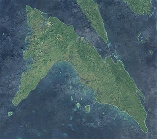
Masbate, officially the Province of Masbate, is an island province in the Philippines located near the midsection of the nation's archipelago. Its provincial capital is Masbate City, the most populous in the province. The province consists of three major islands: Masbate, Ticao and Burias.
Masbate Island is the largest of three major islands of Masbate Province in the Philippines. The other two major islands are Ticao Island and Burias Island. It is the 11th-largest island in both area and population in the Philippines and the world's 155th largest island by area and the world's 70th most populous island. The island is divided into 14 municipalities and 1 city, and has a total population of 731,269 people as of 2020 census. Masbate City is the island's largest settlement with a total population of 104,522 as of 2020.

Burias Island is one of the three major islands of Masbate province in the Philippines. It is separated from the Bicol Peninsula by the Burias Pass. The other two major islands are Ticao Island and Masbate Island. The island has two municipalities, Claveria and San Pascual.

Masbate City, officially the City of Masbate, is a 3rd class component city and capital of the province of Masbate, Philippines. According to the 2020 census, it has a population of 104,522 people.

Aroroy, officially the Municipality of Aroroy, is a municipality in the province of Masbate, Philippines. According to the 2020 census, it has a population of 88,351 people. The town is known for the Kalanay Cave, one of the most important archaeological sites in Masbate province.
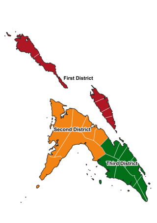
The legislative districts of Masbate are the representations of the province of Masbate in the various national legislatures of the Philippines. The province is currently represented in the lower house of the Congress of the Philippines through its first, second, and third congressional districts.

Bagacay Point Lighthouse is an active lighthouse in Liloan, Cebu, in the Philippines.
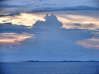
The Jintotolo Channel is the body of water that connects the Sibuyan Sea with the Visayan Sea. It is located between the Philippine islands of Panay and Masbate, and is an important shipping route to and from the Central Visayas.

The Maniguin Island Lighthouse is a lighthouse that marks the Cuyo East Passage, a main shipping route south into the Sulu Sea. The island, also known as Maningning Island or Hammerhead Island, is located 42.6 kilometres (26.5 mi) off of the coast of Culasi, Antique in the Philippines. It has a narrow ridge 33.5 metres (110 ft) high across its southern end, and the remainder of the island is low and wooded, and not more than 4.5 metres (15 ft) high. It is fringed with coral reefs with deep water at their edges. The round cylindrical concrete tower with a gallery on top is located near the southeastern point of the island.
Batag Island Lighthouse is a historic lighthouse on Batag Island off the coast of the town of Laoang in the province of Northern Samar in the Philippines. The light marks the northeastern point of Samar Island and led international ships to the entrance of the San Bernardino Strait marked by the San Bernardino Light. One of the most traveled waterways in the archipelago, together with the Capul Island Light, these stations are invaluable to vessels coming from the Pacific Ocean and entering the country through the San Bernardino Strait on its way to Manila or any other ports of the Philippines.

Capul Island Lighthouse is a historic lighthouse on Titoog Point in San Luis on the northern tip of Capul Island, Northern Samar in the Philippines. It marks the western entrance to the San Bernardino Strait coming in from Ticao Pass.
The Apo Reef Light was a historic lighthouse built on Bajo Apo Island in Apo Reef Natural Park. The park is located in the middle of Mindoro Strait, west of the province of Occidental Mindoro, in the Philippines. The station was established to warn ships of the dangerous shallow reefs in that part of the strait.
Bagatao Island Lighthouse is a historic lighthouse located on Bagatao Island on the eastern side of the entrance to Sorsogon Bay, in the province of Sorsogon in the Philippines. The 29-foot (8.8 m) white cylindrical iron tower is situated on the rocky headland that forms the southern point in the western end of the Island, giving the total light elevation of 135 feet (41 m). The light not only marks the entrance to the bay, but also assists ships in navigating the bend around Ticao Island of Masbate province as they head to San Bernardino Strait and exit to the Pacific Ocean.

The Cape Melville Lighthouse is a historic lighthouse located in the island of Balabac, the southernmost point of the province of Palawan in the Philippines. It is also the southwest corner of the archipelago. The first-order light was constructed by the Spaniards to light Balabac Strait, the treacherous body of water that separates the Philippines from the neighboring country of Malaysia.

Capones Island Lighthouse is a historic lighthouse located in Capones Island off the coast of Barangay Pundaquit, San Antonio, in the province of Zambales, in the Philippines. The light guides international vessels coming from the north to northwest towards Subic Bay or to Corregidor Island Lighthouse at the entrance of Manila Bay. It had first-order lenses when it was first lit on August 1, 1890.

The first Corregidor Island Lighthouse was a historic lighthouse located on the island of Corregidor, in the province of Cavite, Philippines. The light station was one of the most important lights in the archipelago. It was established in 1853 to guide ships to the entrance of Manila Bay on their way to the port of Manila, the most important trading center in the country. This light occupies the converging point of two lines of approach for vessels from the China Sea which steer for the entrance of Manila Bay. Vessels from Hong Kong and the ports of China to the northwest first sight the Capones Island light off the southwest coast of Zambales. Vessels from ports of Indo-China first sight the Corregidor lights in the center. Vessels from Singapore, Indonesia, India, and all the ports of the Philippine Islands, to the south, first sight the Cabra Island light. All lines converge on Corregidor light at the bay entrance.

The Bikol languages or Bicolano languages are a group of Central Philippine languages spoken mostly in the Bicol Peninsula in the southeastern part of Luzon, the neighboring island-province of Catanduanes, and the island of Burias in Masbate.
Jintotolo is an island within the Jintotolo Channel, part of the Province of Masbate, Philippines. It constitutes two barangays of the Municipality of Balud and has a population of 3,687 persons in the 2020 census.

Malabrigo Point Lighthouse, also known as Faro de Punta Malabrigo, is a historic lighthouse located about 115 kilometres (71 mi) southeast of Manila in Barangay Malabrigo, Lobo, Batangas, Philippines. Completed and lit in 1896, it is one of the oldest working lighthouses in the Philippines as well as the best preserved lighthouse in the country. It serves as a guide for ships passing through the Verde Island Passage going to either Batangas Bay or Sibuyan Sea.


