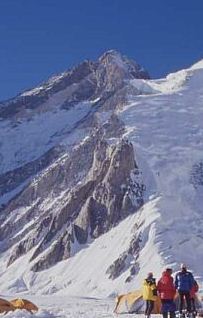
Gasherbrum II ; surveyed as K4, is the 13th highest mountain in the world at 8,035 metres (26,362 ft) above sea level. It is the third-highest peak of the Gasherbrum massif, and is located in the Karakoram, on the border between Gilgit–Baltistan, Pakistan and Xinjiang, China. The mountain was first climbed on July 7, 1956, by an Austrian expedition which included Fritz Moravec, Josef Larch, and Hans Willenpart.

Jengish Chokusu or Victory Peak is the highest mountain in the Tian Shan mountain system at 7,439 metres (24,406 ft). It lies on the China–Kyrgyzstan border between the Ak-Suu District in the Issyk-Kul Region of far Eastern Kyrgyzstan and Wensu County, Xinjiang, China. It is part of the Kakshaal Too, the highest part of the Tian Shan, and is southeast of lake Issyk-Kul.
Gasherbrum III, surveyed as K3a, is a summit in the Gasherbrum massif of the Baltoro Muztagh, a subrange of the Karakoram on the border between Xinjiang, China and Gilgit-Baltistan, Pakistan. It is situated between Gasherbrum II and IV.

Hoh Xil or Kekexili, is an isolated region in the northeastern part of Qinghai-Tibet Plateau. On July 7, 2017, the Hoh Xil in Qinghai was listed among the UNESCO World Heritage Sites as "the largest and highest plateau in the world".

Tashkurgan Tajik Autonomous County is an autonomous county of Kashgar Prefecture, in western Xinjiang, China. The county seat is Tashkurgan. The county is the only Tajik (Pamiri) autonomous county in China.

Altyn-Tagh is a mountain range in Northwestern China that separates the Eastern Tarim Basin from the Tibetan Plateau. The western third is in Xinjiang while the eastern part forms the border between Qinghai to the south and Xinjiang and Gansu to the north.

Muztagh Ata or Muztagata is the second highest of the mountains which form the northern edge of the Tibetan Plateau in China. It is sometimes regarded as being part of the Kunlun Mountains, although physically it is more closely connected to the Pamirs. It is also one of the relatively easier 7,000 m peaks in the world to climb, due to its gentle western slope and the comparatively drier weather of Xinjiang, though a thorough acclimatization period and a very strong physical condition are crucial for success.

Geladaindong Peak is a snow-covered mountain located in Southwestern Qinghai Province of China near the border of Tibet Autonomous Region. It is the tallest mountain in the Tanggula Mountain Range of the Tibetan Plateau with an elevation of 6,621 metres (21,722 ft) above sea level. The traditional source of the Yangtze River, begins with glaciers on its surface. The Yangtze's true source, however, lies 325 km (202 mi) away at the head of the Dam Qu.
Ulugh Muztagh or Ulugh Muztag and Muztag Feng, is an extremely remote mountain group on the northern Qinghai-Tibetan Plateau. Located on the border between the Tibetan Autonomous Region and Xinjiang Uyghur Autonomous Region, it is part of the main range of the Kunlun Mountains of East-Central Asia.

Bogda Peak or Bogda Feng is the highest mountain in the Bogda Shan range, in the eastern Tian Shan mountains, China, at 5,445 m (17,864 ft) and the northernmost 5,000 m or higher peak in Eurasia.

Akto County is a county in Kizilsu Kyrgyz Autonomous Prefecture, Xinjiang Uygur Autonomous Region, China. The county borders Tajikistan and Kyrgyzstan and has two towns, 11 townships, four state-owned farms and a plant nursery under its jurisdiction. The county seat is Akto Town. The county has an area of 24,555 km2 (9,481 sq mi). In 2015 its population was 221,526; in 2017 it was 231,756.

Khüiten Peak, also known in China as Friendship Peak, is a mountain peak in the Altai Range. The international border between China and Mongolia runs across its summit point, which, at 4,356 metres (14,291 ft), is the highest point in the Altais and the highest in both Mongolia and Altay Prefecture in Western China. The peak is covered in snow year-round.
Dafdar, also spelled Daftar, is a township in the Taghdumbash Pamir located in Tashkurgan Tajik Autonomous County, Kashgar Prefecture, Xinjiang Uyghur Autonomous Region, China. The township is located near the China–Pakistan border. The southern part of the township is located in the Trans-Karakoram Tract claimed by India.

Bairiga or Ruoni is the highest peak of Kangri Garpo Range of southeast Tibet Autonomous Region. The region has only recently been explored and before 2009, none of its 47 peaks above 6,000 m had been climbed. Bairiga / Ruoni, which remains unclimbed itself, was photographed for the first time in 1933 by the botanist explorer Frank Kingdon-Ward, at which time it was known as Choembo.
Liushi Shan, also known as Kunlun Goddess Peak, is a mountain in the Kunlun Mountain Range in China. The mountain is located on the border of the Tibet and Xinjiang autonomous regions of China.
Yanshiping is a small town physically situated in the southwest of Qinghai province, China. However, it is under the jurisdiction of Amdo County in the Nagqu Prefecture of the Tibet Autonomous Region. At an elevation of 4,720 metres (15,490 ft), it is one of the highest year-round settlements in the world.
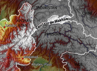
The Afghanistan–China border is a 92-kilometre-long (57 mi) boundary between Afghanistan and China, beginning at the tripoint of both countries with the Pakistan's federally administered territory of Gilgit-Baltistan, following the watershed along the Mustagh Range, and ending at the tripoint with Tajikistan. This short border is in the far northeast of Afghanistan, distant from much of the country or urban areas in either country, at the end of the long, narrow Wakhan Corridor. The Chinese side of the border is in the Chalachigu Valley. The border is crossed by several mountain passes, including Wakhjir Pass in the south and Tegermansu Pass in the north.
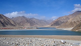
Bulungkol Township is a township of Akto County in Xinjiang, China. Located in the middle west of the county, the township covers an area of 4,585 square kilometers with a population of 7,133. It has 5 administrative villages under its jurisdiction. Its seat is at Bulungkol Village (布伦口村).

Kekeate Pass (Chinese: 柯克阿特达坂; pinyin: Kēkèā'ěrtè Dábǎn), also refer to it as Heiqiazi Pass, Heika Pass or Heiqia Daban[hqz](Chinese: 黑卡子达坂; pinyin: Hēiqiǎzi Dábǎn; lit. 'black hairpin pass') is a mountain pass along the China National Highway 219 with numerous hairpin turns. The mountain pass connects the Yarkand River valley to the west with the Karakash River valley to the east. Located at 309 kilometres (192 mi) from the northern terminus of the G219 highway, it is between the village of Mazar in Kargilik County and the town of Xaidulla in Hotan County near the boundary of the two counties. Western sources often known it as as Kirgizjangal Pass,

Mazar Pass, also refer to it as Sailyak Pass(Chinese: 赛力亚克达坂; pinyin: Sàilìyàkè Dábǎn) is a long mountain pass with numerous hairpin turns along China National Highway 219 (G219), the highway connecting Xinjiang and Tibet. The mountain pass crosses the Kunlun Mountains. It is between the villages of Kudi and Mazar in Kargilik County in southwestern Xinjiang. Western sources often refer to it as Chiragsaldi Pass.