
Baglung District, a part of Gandaki Province, is one of the seventy-seven districts of Nepal. The district, with Baglung as its district headquarters, covers an area of 1,784 km2 (689 sq mi) and has a population (2011) of 268,613.

Darchula District is one of the nine districts of Sudurpashchim Province. The area, with Khalanga as its capital, covers an area of 2,322 km2 (897 sq mi) and has a population (2011) of 133,274. Darchula lies in the west-north corner of the country.
Gorkha District, a part of Gandaki Province, is one of 77 districts of Nepal, and the fourth largest district of the country in terms of area. It is historically linked with the creation of modern Nepal and the name of the legendary Gorkha soldiers. The district, with Gorkha Municipality as its district headquarters, covers an area of 3,610 km2 (1,390 sq mi) and has a population of 252,201, according to the 2021 Nepal census. Gorkha district is the site of the Manakamana Temple, as well as Gorakhnath and Gorakh Kali temples. Several major rivers—including the Chepe, Daraudi, Marsyangdi, Budi Gandaki, and Trishuli—run through the district.

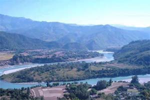
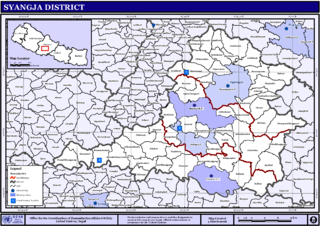
Syangja District, a part of Gandaki Province, is one of the seventy-seven districts of Nepal. The district, with Syangja bazaar as its district headquarters, covers an area of 1,164 km2 (449 sq mi) and had a population of 289,148 It lies in the hilly region at an altitude ranging from about 300 meters along the banks of Kaligandaki river up to a couple of thousands meters above the sea level. It lies at about latitude 28°4'60 North and longitude 83°52'0 East.
Lamatar is a village and former Village Development Committee that is now part of Mahalaxmi Municipality in Province No. 3 of central Nepal.
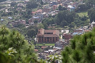
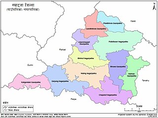
Chapakot is a municipality in the southeastern part of Syangja District in Gandaki Province of central Nepal. The new municipality was formed by merging three existing villages—Ratnapur, Kuwakot and Chapakot—on 18 May 2014. In 12 March 2017 The government implemented the new local administrative structure consisting of 744 local units. With the implementation of this new local administrative structure, the old structure will no longer be in existence. According to the new structure, VDCs will be replaced with village councils. Newly merged VDCs are Sankhar, Sekham, Ward no. 8 of Pakbadi & Ward no. of Malyangkot. The office of the municipality is that of the former Chapakot Municipality.
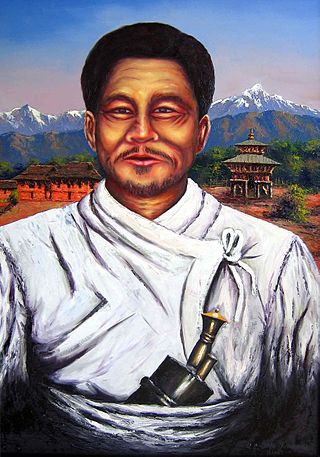
Lakhan Thapa Magar (1835–1877) was a Nepali revolutionary who was declared the "First Martyr of Nepal" by the Nepalese government. He was the first recorded Nepali political dissident and resisted the rule of the Rana dynasty. As a king of Bungkot, he rebelled against the rule of Jang Bahadur Rana and propagandized his political ideology to destroy the Jung Bahadur Rana regime to form a free state and army. He was supported by his close friend Jay Singh Chumi Magar and his minister Jaya Singh Chumi.
Pindikhola was a village development committee in Syangja District in the Gandaki Zone of central Nepal. At the time of the 2011 Nepal census it had a population of 4,956 people living in 1,119 individual households.

Rangethanti is a village town in ward number 5 of Aandhikhola Rural Municipality of Syangja District, Nepal. It is a major educational center of AndhiKhola Rural Municipality.The village town is located approximately 15 km north west from the district headquarter, Putalibazar and approximately 33 km south west from second largest city of Nepal and the provincial capital of Gandaki, Pokhara. The famous and religious river, Andhikhola, flows nearby the town.
Galkot is a municipality in Baglung district of Gandaki province of Nepal. It consists of several VDCs. Nearby cities include Gulmi and Pokhara. Its geographic coordinates are 28°13'24"N 83°25'29"E.
Kaligandaki is a Village council in Syangja District in Gandaki Province, central Nepal. On 12 March 2017, the government of Nepal implemented a new local administrative structure consisting of 744 local units. With the implementation of the new local administrative structure, VDCs have been replaced with municipal & village councils. Kaligandaki is one of these 744 local units. Kaligandaki is created by merging Alamdevi, Birgha Archale, Chandibhanjyang & Shreekrishna Gandaki.
Harinas is a Village council in Syangja District in Gandaki Province, central Nepal.
Dharche Rural Municipality is a Gaunpalika in Gorkha District in Gandaki Province of Nepal. It is divided into 7 wards. On 12 March 2017, the government of Nepal implemented a new local administrative structure, with the implementation of the new local administrative structure, VDCs have been replaced with municipal and Village Councils. Dharche is one of these 753 local units.
Bhimsen Thapa Municipality is a Rural Municipality aka Gaunpalika in Gorkha District in Gandaki Province of Nepal. On 12 March 2017, the government of Nepal implemented a new local administrative structure, with the implementation of the new local administrative structure, VDCs have been replaced with Urban Municipality and Rural Municipality. Bhimsen Thapa is one of these 753 local units. It represents - Masel VDC for ward number 1, Tandrang VDC for ward number 2 and 3, Dhawa VDC for ward number 4, Baguwa VDC for ward number 5, Ashrang VDC for ward number 6, and Borlang VDC for ward number 7 and 8.

Sahid Lakhan Rural Municipality is a Gaunpalika in Gorkha District in Gandaki Province of Nepal. In 12 March 2017, the government of Nepal implemented a new local administrative structure, with the implementation of the new local administrative structure, VDCs have been replaced with municipal and Village Councils. Sahid Lakhan is one of these 753 local units.
Ichchhakamna is an only rural council located in Chitwan District in Bagmati Province of Nepal.
Chaurideurali is a Rural municipality located within the Kavrepalanchowk District of the Bagmati Province of Nepal. The municipality spans 98 square kilometres (38 sq mi) of area, with a total population of 14,076 according to a 2021 Nepal census.
Bihadi is a Rural municipality located within the Parbat District of the Gandaki Province of Nepal. The rural municipality spans 44.80 square kilometres (17.30 sq mi) of area, with a total population of 10828 according to a 2021 Nepal census.
Paiyun is a Rural municipality located within the Parbat District of the Gandaki Province of Nepal. The rural municipality spans 42.65 square kilometres (16.47 sq mi) of area, with a total population of 15,381 according to a 2011 Nepal census.
Devghat is a Rural municipality located within the Tanahun District of the Gandaki Province of Nepal. The rural municipality spans 159 square kilometres (61 sq mi) of area, with a total population of 16,131 according to a 2011 Nepal census.


