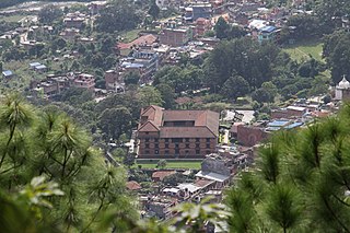
Gorkha District, a part of Gandaki Province, is one of the 77 districts of Nepal, which is the fourth largest district of Nepal and connected historically with the creation of the modern Nepal and the name of the legendary Gorkha soldiers. The district, with Gorkha Municipality as its district headquarters, covers an area of 3,610 km2 (1,390 sq mi) and has a population of 271,061 according to the 2011 Census of Nepal. Gorkha district is the site of the Manakamana Temple. The temples of Gorakh Nath and Gorakh Kali are found in the district. Several major rivers—the Chepe, Daraudi, Marsyangdi, Budi Gandaki, and Trishuli—run through the district.

A Village Development Committee (VDC) in Nepal was the lower administrative part of its Ministry of Federal Affairs and Local Development. Each district had several VDCs, similar to municipalities but with greater public-government interaction and administration. There were 3,157 village development committees in Nepal. Each VDC was further divided into several wards depending on the population of the district, the average being nine wards.
The 1991 Nepal census was a widespread national census conducted by the Nepal Central Bureau of Statistics.

Kadambas is a village and market center of Chautara Sangachowkgadi Municipality in Sindhupalchok District in the Bagmati Zone of central Nepal. The former Village Development Committee was merged to the new municipality in 2017. At the time of the 1991 Nepal census it had a population of 3133 and had 571 houses in the village.

Lisankhu is a village and former village development committee in Sindhupalchok District in Bagmati Province of central Nepal. At the time of the 1991 Nepal census it had a population of 4548 and had 890 houses in the village.

Satungal is a village and former Village Development Committee that is now part of Chandragiri Municipality in Kathmandu District in Province No. 3 of central Nepal. Satungal is also known as Satyapur. At the time of the 1991 Nepal census it had a population of 2,730 people living in 464 households. By the time of the 2001 Nepal census the population had grown to 5,834, spread over 1,375 households. At that time 5,173 of the village population were literate - a literacy rate of 88.7%.

Chisapani is a village in Banke District in Lumbini Province of south-western Nepal, not to be confused with Chisapani in the bank of Karnali River.

Naubasta is a town in Banke District in the Bheri Zone of south-western Nepal. At the time of the 1991 Nepal census it had a population of 11,160 and had 1663 houses in the town.

Chhaikampar is a village development committee in Gorkha District in the Gandaki Zone of northern-central Nepal. At the time of the 1991 Nepal census it had a population of 1,270 and had 244 houses in the village.

Chandeni Mandan is a village development committee in Kabhrepalanchok District in Bagmati Province of central Nepal. At the time of the 1991 Nepal census it had a population of 3,267 and had 618 houses in it.

Chyamrangbesi is a village development committee in Kabhrepalanchok District in Bagmati Province of central Nepal. At the time of the 1991 Nepal census it had a population of 1,520 and had 254 houses in it.

Dolalghat is a village development committee in Kabhrepalanchok District in Bagmati Province of central Nepal.

Ghartichhap is a village development committee in Kabhrepalanchok District in Bagmati Province of central Nepal. At the time of the 1991 Nepal census it had a population of 2,095 and had 308 houses in it.

Johang is a Village Development Committee VDC in Gulmi District in the Lumbini Zone of Western Nepal. At the time of the 2011 Nepal census it had a population of about 10000 living in 1509 individual households.

Situated on the bank of Kaligandaki river, Khadgakot is a town and Village Development Committee, in Gulmi District in the Lumbini Zone of central Nepal. At the time of the 1991 Nepal census it had a population of 4297 persons living in 808 individual households.

Chulachuli is a rural municipality (gaunpalika) out of six rural municipality located in Ilam District of Province No. 1 of Nepal. There are a total of 10 municipalities in Ilam in which 4 are urban and 6 are rural.
Bhakunde is a village development committee in Baglung District in the Dhawalagiri Zone of central Nepal. At the time of the 1991 Nepal census it had a population of 3,833 and had 697 houses in the village. At the time of the 2011 Nepal census it had a population of 4,952 among which 2,443 were female and 2,509 were male. There were about 831 houses in the village.

Jayanagar is a village development committee in Kapilvastu District in the Lumbini Zone of southern Nepal. At the time of the 1991 Nepal census it had a population of 5886. The government of Nepal has integrated Jayanagar, Mahendrakot and Dubiya village development committees into Buddhanhumi municipality.

Pathari Shanishchare (पथरी-शनिश्चरे) is a Municipality in Morang District in the Koshi Zone of south-eastern Nepal. It was formed by merging three existing village development committees i.e. Hasandaha, Pathari and Sanischare in May 2014.

Sundar Haraicha is a municipality in Morang District of Province No. 1 in Nepal that was established on 10 March 2017 by merging the former municipalities Sundar Dulari and Koshi Haraicha. At the time of the 2011 Nepal census, the localities formed had a joint population of 80,518 people living in 18,610 individual households.


