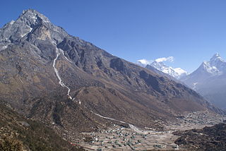
Khumjung is a village in Khumbu Pasanglhamu rural municipality of Solukhumbu District in Province No. 1 of north-eastern Nepal. It is located in the Khumbu subregion inside Sagarmatha National Park, a world heritage site. The village is at an elevation of 3,790 metres above sea level, and is situated near Mount Khumbila.

Baglung District, a part of Gandaki Province, is one of the seventy-seven districts of Nepal. The district, with Baglung as its district headquarters, covers an area of 1,784 km2 (689 sq mi) and has a population (2011) of 268,613.
Dailekh District a part of Karnali Province, is one of the 77 districts of Nepal. The district, with Dailekh as its district headquarters, covers an area of 1,502 km2 (580 sq mi) and had a population of 225,201 in 2001 and 261,770 in 2011.

Mugu District, a part of Karnali Province, is one of the seventy-seven districts of Nepal. The district, with Gamgadhi as its district headquarters, covers an area of 3,535 km2 (1,365 sq mi) and had a population (2011) of 55,286. Mugu is known for being both the most remote district in Nepal, as well as the least developed.

Solukhumbu District (Nepali: सोलुखुम्बु जिल्ला[solukʰumbu], Sherpa: ཤར་ཁུམ་བུ་རྫོང་།, Wylie: shar khum bu dzong) is one of 14 districts of Province No. 1 of eastern Nepal. As the name suggests, it consists of the subregions Solu and Khumbu.

Bandipur is a hilltop settlement and a rural municipality in Tanahun District, Gandaki province of Nepal. Because of its preserved, old time cultural atmosphere, Bandipur has increasingly been coming to the attention of tourism. At the time of the 2011 Nepal census it had a population of total 15,591 people living in 3,750 individual households. Bandipur is famous for Newari people and their cultures.

Dunai is a village and former Village Development Committee that is now part of Thuli Bheri Municipality in Nepal. Dunai is also the district headquarters of Dolpa District. The town on the banks of the Thuli Bheri River resides at about 2,000 metres (6,562 ft) elevation.

A village development committee in Nepal was the lower administrative part of its Ministry of Federal Affairs and Local Development. Each district had several VDCs, similar to municipalities but with greater public-government interaction and administration. There were 3,157 village development committees in Nepal. Each village development committee was further divided into several wards depending on the population of the district, the average being nine wards.
The 1991 Nepal census was a widespread national census conducted by the Nepal Central Bureau of Statistics.
Mahakali is a village development committee in Baitadi District in the Mahakali Zone of western Nepal. It is located on the Mahakali River which is also the border with Uttarakhand state, India across from Jhulaghat. Amraad and Basku are main places in this village. Indian and Nepalese nationals cross without restrictions, however there is a customs checkpoint for goods.
Gajuri(Nepali: गजुरी ; gajuri) is a Gaupalika in Dhading District in the Bagmati Zone of central Nepal. It has a literacy rate of 64.28%. The city hosts as one of the city with highest literacy rate in the Dhading district. The local body was formed by merging three VDCs namely Gajuri, Pida, Nepal, Kiranchok.
Naubasta is a town in Banke District in the Bheri Zone of south-western Nepal. At the time of the 1991 Nepal census it had a population of 11,160 and had 1663 houses in the town.
Laprak is situated in the northern part of Gorkha, Nepal village development committee in Gorkha District in the Gandaki Zone of northern-central Nepal. Laprak is densely inhabited by Gurungs and few number of Sunars. At the time of the 1991 Nepal census it had a population of 2,165 and had 462 houses in the village.

Dolalghat is a village development committee in Kabhrepalanchok District in Bagmati Province of central Nepal.
Bangesal is both a town and Pyuthan District, Nepal's southernmost Village Development Committee; also Pyuthan's lowest in elevation. This VDC is in the Siwalik hills north of Deukhuri Valley.
Bharat Pokhari is a town in Kaski District in the Gandaki Province of northern-central Nepal. It lies at the height of 657 to 1600 meters above sea level. At the time of the 1991 Nepal census it had a population of 8,889 persons living in 1782 individual households. Bharat Pokhari was a Village Development Committee, and it is merged with Lekhnath Municipality.
Karkineta is a village development committee in Parbat District in the Dhawalagiri Zone of central Nepal. At the time of the 1991 Nepal census it had a population of 2166 people living in 432 individual households. Karkineta is at the height of 1609.3 meters from the sea level. The Village has one high school and college. Students from nearby villages attend the schools and college in Karkineta.
Bhakunde is a village development committee in Baglung District in the Dhawalagiri Zone of central Nepal. At the time of the 1991 Nepal census it had a population of 3,833 and had 697 houses in the village. At the time of the 2011 Nepal census it had a population of 4,952 among which 2,443 were female and 2,509 were male. There were about 831 houses in the village.

Bayarban was a village development committee in the Morang District, Koshi Zone of south-eastern Nepal. It was named for the village of Bayarban Bazar. In 2017 it was absorbed by the newly created Kanepokhari Rural Municipality.
Pathari Shanishchare (पथरी-शनिश्चरे) is a Municipality in Morang District in the Koshi Zone of south-eastern Nepal. It was formed by merging three existing village development committees i.e. Hasandaha, Pathari and Sanischare in May 2014.


