Burdick, Kansas

Last updated

Burdick, Kansas
Map of Morris Co, Ks, USA.png
USA Kansas location map.svg
Red pog.svg
Burdick
Usa edcp location map.svg
Red pog.svg
Burdick
Coordinates: 38°33′49″N96°50′44″W / 38.56361°N 96.84556°W / 38.56361; -96.84556 [1]
Country United States
State Kansas
County Morris
Founded1880s
Named for Ms Burdick
Elevation
[1]
1,453 ft (443 m)
Population
 (2020) [2]
  Total62
Time zone UTC-6 (CST)
  Summer (DST) UTC-5 (CDT)
ZIP code
66838
Area code 785
FIPS code 20-09300 [1]
GNIS ID 477148 [1]

Burdick is an unincorporated community in Morris County, Kansas, United States. [1] It was named after Ms. Burdick, the sweetheart of a Santa Fe Railroad official in 1887. As of the 2020 census, the population of the community and nearby areas was 62. [2] It is located southeast of Herington, about 5.6 miles (9.0 km) east of the intersection of U.S. Route 77 (aka U.S. Route 56) highway and 340th Street, or about 6.5 miles (10.5 km) east of Lost Springs.

Contents

History

Early history

For many millennia, the Great Plains of North America was inhabited by nomadic Native Americans. From the 16th century to 18th century, the Kingdom of France claimed ownership of large parts of North America. In 1762, after the French and Indian War, France secretly ceded New France to Spain, per the Treaty of Fontainebleau.

19th century

1893 Railroad Map Map elk chase kansas.jpg
1893 Railroad Map
1915 Railroad Map of Morris County Stouffer's Railroad Map of Kansas 1915-1918 Morris County.png
1915 Railroad Map of Morris County

In 1802, Spain returned most of the land to France. In 1803, most of the land for modern day Kansas was acquired by the United States from France as part of the 828,000 square mile Louisiana Purchase for 2.83 cents per acre.

From the 1820s to the 1870s, one of the most significant land routes in the United States was the Santa Fe Trail. It was located approximately 3 miles (4.8 km) north of Burdick. A large stone stage station, named "Six Mile Stage Station" was built at this location as a rest stop. In 1863, Charles Atkinson witnessed a raid on this station conducted by approximately 600 Cheyenne Indians. DAR Marker #29 was dedicated on October 9, 1908 at this location. [3]

In 1854, the Kansas Territory was organized, then in 1861 Kansas became the 34th U.S. state. In 1859, Morris County was established within the Kansas Territory, which included the land for modern day Burdick.

In 1880, a Swedish settlement called Linsdale was created, consisting of Swedish immigrants from Henry and Mercer counties of Illinois. In 1887, the community name was changed to Burdick, in honor of Ms. Burdick, the sweetheart of a Santa Fe Railroad official. [4]

In 1887, Atchison, Topeka and Santa Fe Railway built a branch line from Neva (3 miles west of Strong City) to Superior, Nebraska. This branch line connects Strong City, Neva, Rockland, Diamond Springs, Burdick, Lost Springs, Jacobs, Hope, Navarre, Enterprise, Abilene, Talmage, Manchester, Longford, Oak Hill, Miltonvale, Aurora, Huscher, Concordia, Kackley, Courtland, Webber, Superior. In 2006, the line from Neva to Lost Springs was pulled but the right of way has not been abandoned. This branch line was originally called "Strong City and Superior line" but later the name was shortened to the "Strong City line". In 1996, the Atchison, Topeka and Santa Fe Railway merged with Burlington Northern Railroad and renamed to the current BNSF Railway. Most locals still refer to this railroad as the "Santa Fe".

A post office was established in Burdick on August 29, 1887. [5]

Geography

Burdick is located at 38°33′49″N96°50′44″W / 38.56361°N 96.84556°W / 38.56361; -96.84556 (38.5636222, -96.8455682) [6] at an elevation of 1,453 feet (443 m). It is approximately 6 miles (9.7 km) east of Lost Springs.

Climate

The climate in this area is characterized by hot, humid summers and generally mild to cool winters. According to the Köppen Climate Classification system, Burdick has a humid subtropical climate, abbreviated "Cfa" on climate maps. [7]

Demographics

Historical population
CensusPop.Note
2020 62
U.S. Decennial Census

For statistical purposes, the United States Census Bureau has defined this community as a census-designated place (CDP).

2020 census

The 2020 United States census counted 62 people, 27 households, and 21 families in Burdick. [8] [9] The population density was 61.6 per square mile (23.8/km2). There were 37 housing units at an average density of 36.8 per square mile (14.2/km2). [9] [10] The racial makeup was 90.32% (56) white or European American (88.71% non-Hispanic white), 0.0% (0) black or African-American, 0.0% (0) Native American or Alaska Native, 0.0% (0) Asian, 0.0% (0) Pacific Islander or Native Hawaiian, 0.0% (0) from other races, and 9.68% (6) from two or more races. [11] Hispanic or Latino of any race was 3.23% (2) of the population. [12]

Of the 27 households, 25.9% had children under the age of 18; 77.8% were married couples living together; 22.2% had a female householder with no spouse or partner present. 18.5% of households consisted of individuals and 14.8% had someone living alone who was 65 years of age or older. [9] The average household size was 1.8 and the average family size was 1.8. [13] The percent of those with a bachelor’s degree or higher was estimated to be 4.8% of the population. [14]

19.4% of the population was under the age of 18, 1.6% from 18 to 24, 16.1% from 25 to 44, 25.8% from 45 to 64, and 37.1% who were 65 years of age or older. The median age was 57.0 years. For every 100 females, there were 121.4 males. [9] For every 100 females ages 18 and older, there were 127.3 males. [9]

The 2016-2020 5-year American Community Survey estimates show that the median household income was $23,919 (with a margin of error of +/- $326) and the median family income was $23,929 (+/- $364). [15] The median income for those above 16 years old was $5,882 (+/- $2,285). [16]

Economy

Although Burdick is unincorporated, it has a post office with the ZIP code of 66838. [17]

Area events

Education

The community is served by Centre USD 397 public school district. The high school is a member of T.E.E.N., a shared video teaching network between five area high schools. [18]

History

In the 1910s, Burdick and Diamond Springs formed a high school district. In 1921, Diamond Valley High School was completed. The first class graduated in 1923 with three students. Due to decreasing attendance, the high school closed its doors in 1957. [19] [20]

Films

Media

Print

Infrastructure

Transportation

U.S. Route 77 is 5.0 miles (8.0 km) west, and U.S. Route 56 is 6.5 miles (10.5 km) north of the community.

Utilities

Notable people

See also

Related Research Articles

<span class="mw-page-title-main">Morris County, Kansas</span> County in Kansas, United States

Morris County is a county located in the U.S. state of Kansas. Its county seat and largest city is Council Grove. As of the 2020 census, the county population was 5,386. The county was named for Thomas Morris, a U.S. Senator from Ohio and anti-slavery advocate.

<span class="mw-page-title-main">Jewell County, Kansas</span> County in Kansas, United States

Jewell County is a county located in the U.S. state of Kansas. Its county seat and most populous city is Mankato. As of the 2020 census, the county population was 2,932. The county was named for Lewis Jewell, a Lieutenant Colonel of the 6th Regiment Kansas Volunteer Cavalry.

<span class="mw-page-title-main">Dickinson County, Kansas</span> County in Kansas, United States

Dickinson County is a county in Central Kansas. Its county seat and most populous city is Abilene. As of the 2020 census, the county population was 18,402. The county was named in honor of Daniel Dickinson, a U.S. Senator from New York that was a Kansas statehood advocate.

<span class="mw-page-title-main">Ellinwood, Kansas</span> City in Barton County, Kansas

Ellinwood is a city in the southeast corner of Barton County, Kansas, United States. As of the 2020 census, the population of the city was 2,011.

<span class="mw-page-title-main">Aurora, Kansas</span> City in Cloud County, Kansas

Aurora is a city in Cloud County, Kansas, United States. As of the 2020 census, the population of the city was 56.

<span class="mw-page-title-main">Cambridge, Kansas</span> City in Cowley County, Kansas

Cambridge is a city in Cowley County, Kansas, United States. As of the 2020 census, the population of the city was 92.

<span class="mw-page-title-main">Enterprise, Kansas</span> City in Dickinson County, Kansas

Enterprise is a city in Dickinson County, Kansas, United States. As of the 2020 census, the population of the city was 708.

<span class="mw-page-title-main">Baldwin City, Kansas</span> City in Kansas, United States

Baldwin City is a city in Douglas County, Kansas, United States, about 12 miles (19 km) south of Lawrence. As of the 2020 census, the population of the city was 4,826. The city is home to Baker University, the state's oldest four-year university.

<span class="mw-page-title-main">Coolidge, Kansas</span> City in Hamilton County, Kansas

Coolidge is a city in Hamilton County, Kansas, United States. As of the 2020 census, the population of the city was 80. It is located along Highway 50 about 1 miles east of the Colorado-Kansas border.

<span class="mw-page-title-main">Gardner, Kansas</span> City in Kansas, United States

Gardner is a city in Johnson County, Kansas, United States. As of the 2020 census, the population of the city was 23,287. It is located within the Kansas City metropolitan area.

<span class="mw-page-title-main">Durham, Kansas</span> City in Marion County, Kansas

Durham is a city in Marion County, Kansas, United States. As of the 2020 census, the population of the city was 89. The city took its name from Durham cattle. It is located about 8.5 miles (14 km) north of Hillsboro on the west side of K-15 highway next to a railroad.

<span class="mw-page-title-main">Lost Springs, Kansas</span> City in Marion County, Kansas

Lost Springs is a city in Marion County, Kansas, United States. As of the 2020 census, the population of the city was 55. The city was named for a nearby lost spring that was a camping spot along the 19th century Santa Fe Trail. It is located south of Herington, about 0.6 miles west of the intersection of U.S. Route 77 highway and 340th Street next to the Union Pacific Railroad.

<span class="mw-page-title-main">Galva, Kansas</span> City in McPherson County, Kansas

Galva is a city in McPherson County, Kansas, United States. As of the 2020 census, the population of the city was 834.

<span class="mw-page-title-main">Council Grove, Kansas</span> City in Morris County, Kansas

Council Grove is a city and county seat in Morris County, Kansas, United States. As of the 2020 census, the population of the city was 2,140. It was named after an agreement between American settlers and the Osage Nation allowing settlers' wagon trains to pass westward through the area on the Santa Fe Trail. Pioneers gathered at a grove of trees so that wagons could band together for their trip west.

<span class="mw-page-title-main">Elkhart, Kansas</span> City in Morton County, Kansas

Elkhart is a city in and the county seat of Morton County, Kansas, United States. As of the 2020 census, the population of the city was 1,888. The south edge of the city is the Kansas-Oklahoma state border, and the city is 8.5 miles (13.7 km) from the Kansas-Colorado border.

<span class="mw-page-title-main">Burlingame, Kansas</span> City in Osage County, Kansas

Burlingame is a city in Osage County, Kansas, United States. As of the 2020 census, the population of the city was 971.

<span class="mw-page-title-main">Courtland, Kansas</span> City in Republic County, Kansas

Courtland is a city in Republic County, Kansas, United States. As of the 2020 census, the population of the city was 294.

<span class="mw-page-title-main">Chase, Kansas</span> City in Rice County, Kansas

Chase is a city in Rice County, Kansas, United States. As of the 2020 census, the population of the city was 396.

<span class="mw-page-title-main">Caldwell, Kansas</span> City in Sumner County, Kansas

Caldwell is a city in Sumner County, Kansas, United States. As of the 2020 census, the population of the city was 1,025.

<span class="mw-page-title-main">Herington, Kansas</span> City in Dickinson and Morris Counties of Kansas

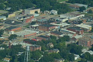
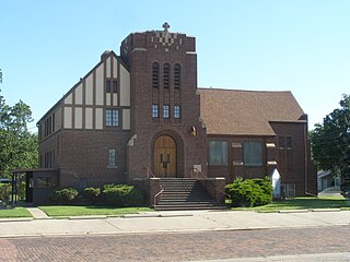
Herington is a city in Dickinson and Morris counties in the U.S. state of Kansas. As of the 2020 census, the population of the city was 2,109.

References

  1. 1 2 3 4 5 "Burdick, Kansas", Geographic Names Information System , United States Geological Survey, United States Department of the Interior
  2. 1 2 "Profile of Burdick (CDP), Kansas in 2020". United States Census Bureau. Archived from the original on November 13, 2021. Retrieved November 13, 2021.
  3. 1997 Survey of DAR Markers in Kansas
  4. [Welcome to Burdick, Pop. 60; PBS.org]
  5. "Kansas Post Offices, 1828-1961". Kansas Historical Society. Retrieved June 15, 2014.
  6. Geographic Names Information System Feature Detail Report, Geographic Names Information System, 1978-10-13. Accessed 2008-04-28.
  7. Climate Summary for Burdick, Kansas
  8. "US Census Bureau, Table P16: HOUSEHOLD TYPE". data.census.gov. Retrieved December 31, 2023.
  9. 1 2 3 4 5 "US Census Bureau, Table DP1: PROFILE OF GENERAL POPULATION AND HOUSING CHARACTERISTICS". data.census.gov. Retrieved December 31, 2023.
  10. Bureau, US Census. "Gazetteer Files". Census.gov. Retrieved December 30, 2023.
  11. "US Census Bureau, Table P1: RACE". data.census.gov. Retrieved December 31, 2023.
  12. "US Census Bureau, Table P2: HISPANIC OR LATINO, AND NOT HISPANIC OR LATINO BY RACE". data.census.gov. Retrieved December 31, 2023.
  13. "US Census Bureau, Table S1101: HOUSEHOLDS AND FAMILIES". data.census.gov. Retrieved December 31, 2023.
  14. "US Census Bureau, Table S1501: EDUCATIONAL ATTAINMENT". data.census.gov. Retrieved December 31, 2023.
  15. "US Census Bureau, Table S1903: MEDIAN INCOME IN THE PAST 12 MONTHS (IN 2020 INFLATION-ADJUSTED DOLLARS)". data.census.gov. Retrieved December 31, 2023.
  16. "US Census Bureau, Table S2001: EARNINGS IN THE PAST 12 MONTHS (IN 2020 INFLATION-ADJUSTED DOLLARS)". data.census.gov. Retrieved December 31, 2023.
  17. Zip Code Lookup
  18. T.E.E.N. video teaching network
  19. Burdick Old & New photos; Photo 3.
  20. Burdick Old & New photos; Photo 4.
  21. Former senator Nancy Landom Kassebaum calls Flint Hills home; Marion County Record; September 30, 2015.

Further reading

Historical
Maps