
The River Tyne is a river in North East England. Its length is 73 miles (118 km). It is formed by the North Tyne and the South Tyne, which converge at Warden Rock near Hexham in Northumberland at a place dubbed 'The Meeting of the Waters'.

Northumberland National Park is the northernmost national park in England. It covers an area of more than 1,050 square kilometres (410 sq mi) between the Scottish border in the north to just south of Hadrian's Wall. The park lies entirely within Northumberland, covering about a quarter of the county.

Kielder Water is a large man-made reservoir in Northumberland in North East England. It is the largest artificial lake in the United Kingdom by capacity of water and it is surrounded by Kielder Forest, one of the biggest man-made woodlands in Europe. The scheme was planned in the late 1960s to satisfy an expected rise in demand for water to support a booming UK industrial economy. But the decline of traditional heavy industry, together with more water-efficient industrial processes and better control of water supply leakage, served to undermine the original justification for the reservoir and the government-funded project has been criticised as a white elephant.

Kielder Forest is a large forestry plantation in Northumberland, England, surrounding Kielder village and the Kielder Water reservoir. It is the largest man-made woodland in England with three-quarters of its 250 square miles (650 km2) covered by forest. The majority of the forest lies within Kielder Water and Forest Park, with the southern tip known as Wark Forest lying within Northumberland National Park. The forest is next to the Anglo-Scottish border.
Kielder a village in Northumberland, England.
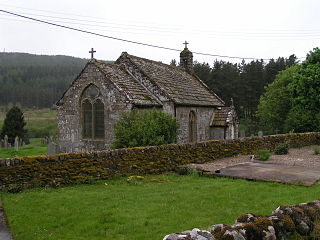
Byrness is a village within Rochester civil parish in Northumberland, England. It is approximately 37 miles (60 km) north-west of Newcastle upon Tyne on the A68, and is the last village in England before the A68 climbs the Cheviot Hills to cross Carter Bar into Scotland. Byrness's village church features a stained-glass window commemorating the workers who died during the building of Catcleugh Reservoir nearby. Much of the village was built by the Forestry Commission to house workers for the extensive forests that surround it. Situated on the Pennine Way, Byrness has an inn, campsite and other accommodation offering rest and sustenance for weary walkers.

Redesdale is a valley in western Northumberland, England. It is formed by the River Rede, which rises in the Cheviots and flows down to join the North Tyne at Redesmouth. Redesdale is traversed by the A68 trunk road, which enters Scotland via Carter Bar at the head of the valley.

Kershope Burn is a small river; a tributary of both the Liddel Water and the River Esk; its final destination is the Solway Firth. The early stages begin in the Border Forest, from where it flows in a south westerly direction, followed in its entirety by the border between England and Scotland.

Kielder is a small, remote village in western Northumberland, England. Located at the head of Kielder Water and in the north west of Kielder Forest, the village is within three miles of the Scottish border.

The Rede is a river in Northumberland, England. The river rises on Carter Fell on the Anglo-Scottish border feeding Catcleugh Reservoir and joins the River North Tyne below the village of Redesmouth. The Rede is one of only two rivers in the North East of England that has the freshwater pearl mussel in its waters.

Peel Fell is the highest hill in the Kielder Forest region of England, making it the highest hill for several miles in each direction until the Cheviot Hills to the north-east are reached. Because of this, it has enough relative height to make it a Marilyn. It lies in both the county of Northumberland and the county of Roxburghshire, which is now governed by the Scottish Borders council, as the summit is on the border with Scotland.
Sighty Crag is a[hill in the southern part of the Kielder Forest region in northern England, a region which also includes its fellow Marilyns of Peel Fell and Larriston Fells. It is separated from its higher and more shapely counterpart, Peel Fell, by the low valley in which sits the village of Kielder.
The Border Counties Railway was a railway line connecting Hexham in Northumberland, with Riccarton Junction on the Waverley Route in Roxburghshire.

Kielder Observatory is an astronomical observatory located in Kielder Forest, Northumberland, England. The site is on Black Fell, overlooking Kielder Water near the Scottish border. It is accessible from James Turrell's Kielder Skyspace via a half-mile long forest track.
The Kielder Forest Star Camp is an annual star party, held each autumn and spring in Kielder Forest in northern England. The area is known for its dark skies.
Kielder railway station is a closed railway station that served the village hamlet of Kielder, Northumberland.

Saughtree is a hamlet in the Scottish Borders at the junction of the B6357 and an unnamed road from Kielder village in Northumberland, England. It is at the confluence of the Liddel Water and Dawston Burn, in Liddesdale. The nearest settlements on the B6357 are Bonchester Bridge, Newcastleton and Kielder village. It is approximately 6 km from the border with England.
Northumbrian Water Limited is a water company in the United Kingdom, providing mains water and sewerage services in the English counties of Northumberland, Tyne and Wear, Durham and parts of North Yorkshire, and also supplying water as Essex and Suffolk Water. It is a wholly owned subsidiary of Northumbrian Water Group.

A skyspace is an architectural design in which a room, which is painted in a neutral color has a large hole in its ceiling which opens directly to the sky. The room, whose perimeter has benches, allows observers to look at the sky in such a way as though it were framed. LED lights which surround the hole can change colors to affect the viewer's perception of the sky.

National Cycle Network (NCN) Route 10 is a Sustrans National Route that runs from Cockermouth to North Shields in the United Kingdom. The route is 217 km long and is fully open and signed in both directions.

