Bywell Bridge | |
|---|---|
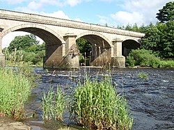 Bywell Bridge | |
| Coordinates | 54°57′07″N1°55′12″W / 54.952°N 1.920°W |
| OS grid reference | NZ052619 |
| Carries | B6309 |
| Crosses | River Tyne |
| Locale | Northumberland |
| Heritage status | Grade II listed [1] [2] |
| Preceded by | Styford Bridge |
| Followed by | Ovingham Bridges |
| Characteristics | |
| Design | Arch bridge |
| Material | Ashlar stone |
| No. of spans | 5 |
| No. of lanes | Single-track road |
| History | |
| Architect | George Basevi [3] |
| Construction start | 1836 [4] |
| Construction end | 1838 |
| Construction cost | £15,000 |
| Opened | 1838 [3] [4] |
| Location | |
 | |
Bywell Bridge is a 19th-century stone bridge across the River Tyne. It is a Grade II listed building. [1] [2] [4]