The A68 is a major road in the United Kingdom, running from Darlington in England to the A720 in Edinburgh, the capital of Scotland. It crosses the Anglo-Scottish border at Carter Bar and is the only road to do so for some distance either way; the next major crossings are the A697 from Coldstream to Cornhill-on-Tweed in the east, and the A7 near Canonbie to the west.

Corbridge is a village in Northumberland, England, 16 miles (26 km) west of Newcastle and 4 miles (6 km) east of Hexham. Villages nearby include Halton, Acomb, Aydon and Sandhoe.

Hexham is a market town and civil parish in Northumberland, England, on the south bank of the River Tyne, formed by the confluence of the North Tyne and the South Tyne at Warden nearby, and close to Hadrian's Wall. Hexham was the administrative centre for the Tynedale district from 1974 to 2009. In 2011, it had a population of 13,097.

The A69 is a major northern trunk road in England, running east–west across the Pennines, through the counties of Tyne and Wear, Northumberland and Cumbria. Originally, the road started in the centre of Newcastle upon Tyne then later near Birtley, but since the creation of the A1 Western Bypass around Newcastle upon Tyne, it now starts at Denton Burn, a suburb of Newcastle upon Tyne.

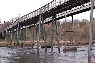
Haydon Bridge is a village in Northumberland, England, which had a population of 2,184 in the 2011 census. Its most distinctive features are the two bridges crossing the River South Tyne: the picturesque original bridge after which the village was named and a modern bridge which used to carry the A69 road. A bypass was completed in 2009 and the A69 now bypasses the village to the south.

The A689 is a road in northern England that runs east from the A595, 3.1 miles (5.0 km) to the west of Carlisle in Cumbria, to Hartlepool in County Durham.

Aydon is a village and former civil parish, now in the parish of Corbridge, in Northumberland, England. It is about 2 miles (3 km) northeast of Corbridge on the B6321 road. The village is about 18 miles (29 km) from Newcastle upon Tyne along the main A69 road. The A68 road is close by, leading to Jedburgh and Darlington. Aydon lies near the course of the ancient Roman monument, Hadrian's Wall. In 1951 the parish had a population of 90.

Bardon Mill is a small village in Northumberland, within the vicinity of the ancient Hadrian's Wall. It is located around 10+1⁄2 miles from Hexham, 26+1⁄2 mi (43 km) from Carlisle, and 32 mi (51 km) from Newcastle upon Tyne.

Bywell is a village and civil parish in Northumberland, England. It is situated on the north bank of the River Tyne opposite Stocksfield, between Hexham and Newcastle. The parish has a population of around 380 and Newton to the north is now its most populous settlement.
Ovingham is a village and civil parish in the Tyne Valley of south Northumberland, England. It lies on the River Tyne 10 miles (16 km) east of Hexham with neighbours Prudhoe, Ovington, Wylam and Stocksfield.

Riding Mill is a village near Hexham in Northumberland, England. It is part of the civil parish of Broomhaugh and Riding. It is served by Riding Mill railway station and by a frequent bus service on the route from Hexham to Newcastle.

Greenhead is a village in Northumberland, England. The village is on the Military Road (B6318), about 17 miles (27 km) from Chollerford, 3 miles (5 km) from Haltwhistle and 9 miles (14 km) from Brampton, Cumbria along the A69 road. The A69 bypasses the village, but until the 1980s all vehicular traffic passed through it. The village lies just outside the Northumberland National Park, close to Hadrian's Wall. Just to the north of the village is the 12th-century Thirlwall Castle, recently restored and opened to the public. Nearby villages include Upper Denton and Haltwhistle.

The A696 is a major road in Northern England, that runs from Otterburn in Northumberland to Newcastle upon Tyne.
Henshaw is a small village and civil parish in Northumberland, within the vicinity of the ancient Hadrian's Wall. It is located around 11.5 miles (19 km) from Hexham, 25.5 miles (41 km) from Carlisle, and 33 miles (53 km) from Newcastle upon Tyne.

Horsley is a small village and civil parish in Northumberland, England. The village lies on the top of a south-facing hill above the River Tyne, around 11 miles (18 km) from Newcastle upon Tyne and 12 miles (19 km) from Hexham.

Corsenside is one of the largest parishes in Northumberland, however the area is mainly a vast expanse of rolling hills and farmland, with three tiny villages: West Woodburn, East Woodburn and Ridsdale with about 600 inhabitants in total. The area runs alongside the A68 road about 17 miles (27 km) north of Corbridge. The A68 roughly follows the route of the old Roman 'Dere Street'. There are many historic points of interest in this area including the remains of the Roman Camp of Habitancum, Bell Knowe an Iron Age burial site, and the remains of Ridsdale Iron Works, which had its heyday in the Industrial Revolution.
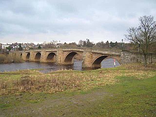
Corbridge Bridge is a 17th-century stone bridge across the River Tyne at Corbridge, Northumberland, England.

The A186 is a road in Tyne and Wear, England. It runs between the A1 Junction 75, and the eastern end of the A69 to the A192 in Whitley Bay. It follows the old A69 into Newcastle-upon-Tyne city centre.

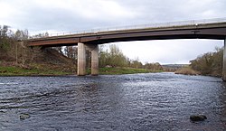
Haltwhistle A69 Bridge, West is a concrete bridge across the River South Tyne at Haltwhistle in Northumberland, England.
The A1 road around Gateshead and Newcastle upon Tyne after arriving from the south as the A1(M) from its origin in London, currently runs from the A1(M) terminus at Birtley. It then swings to the west of both Gateshead and Newcastle via Coal House, Lobley Hill, Metrocentre, Swalwell, Blaydon Bridge, West Denton, Fawdon and Wideopen to Seaton Burn interchange before continuing north towards Edinburgh.