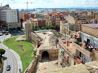
Tarragona is a coastal city and municipality in Catalonia (Spain). It is the capital and largest town of Tarragonès county, the Camp de Tarragona region and the province of Tarragona. Geographically, it is located on the Costa Daurada area on the Mediterranean shore.

Amposta is the capital of the comarca of Montsià, in the province of Tarragona, Catalonia, Spain, 190 km south of Barcelona on the Mediterranean Coast. It is located at 8 metres above sea level, on the Ebre river, not far from its mouth. Its population was 20,606 in 2018.
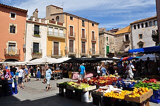
Palamós is a town and municipality in the Mediterranean Costa Brava, located in the comarca of Baix Empordà, in the province of Girona, Catalonia, Spain. Palamós is located at the northern end of a large bay. The town is by-passed by the C31 which connects the coastal towns of the central Costa Brava with Girona. Palafrugell lies 8.5 kilometres (5.3 mi) to the north and Castell-Platja d'Aro 7 kilometres (4.3 mi) to the south.

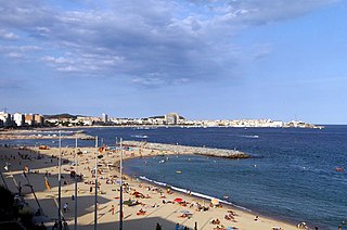
Cambrils is a coastal town in the comarca of Baix Camp, province of Tarragona, Catalonia, Spain. The town is near the tourist town Salou and is frequently visited by those travelling by air using Reus Airport.

Garraf, is a comarca (county) in the Penedès region in Catalonia, Spain. It is named after the Garraf Massif. The capital is the city of Vilanova i la Geltrú.

Tordera is a city in the comarca of Maresme, province of Barcelona, Catalonia, Spain, situated 64 km from Barcelona and 36 km from Girona on the edge of the Montnegre natural park. Its population as of 2010 was 15,641.

Portbou is a town in the Alt Empordà county, in the Province of Girona, Catalonia, Spain. It has a population of 1077 people (2018).

Vilanova i la Geltrú is the capital city of Garraf comarca, in the province of Barcelona, Catalonia, Spain. Historically, it is the result of the aggregation of the medieval center of La Geltrú with the center built outside the medieval walls, Vilanova. Initially, the lands of Vilanova belonged to Cubelles, the neighboring town. The city of Vilanova i la Geltrú has a growing population of approximately 66,000, and is situated 40 km south-west of Barcelona, with the coastal resort of Sitges some 10 km to the north-east.

L'Ametlla de Mar, also called la Cala, is a municipality within the comarca of Baix Ebre, situated in the coastal region between the "Cap de Terme" and the "barranc de l'Àliga". It is limited to the south by the boundary with El Perelló, to the north-west with that of Tivissa, the Ebro riviera, and to the north-east with that of Vandellós and l'Hospitalet de l'Infant,.

Sant Vicenç dels Horts is a municipality in the Province of Barcelona in Catalonia, Spain. It is situated on the right bank of the Llobregat river, on the N-340 road from Molins de Rei to Vilafranca del Penedès. The main rail lines of the Llobregat corridor pass through the town: the station is served by the FGC services S3, S4, S8, S9, R5 and R6. The remains of an Iberic village are visible at Puig Castellar.
Montcada i Reixac, often referred to as simply Montcada, is a municipality in the comarca of the Vallès Occidental in Catalonia, Spain. It is situated at the confluence of the Ripoll river and the Besós river, and very close to the northernmost neighbourhoods of the city of Barcelona and is therefore a part of the metropolitan area of Barcelona. It had 33,656 inhabitants according to the 2010 census.
L'Ampolla is a municipality in the comarca of the Baix Ebre in Catalonia, Spain. It was created in 1990 by the division of the municipality of el Perelló. It is situated on the coast south of l'Ametlla de Mar, and is an important tourist centre and minor fishing port. The town is served by the A-7 autopista, the N-340 coast road and by a station on the RENFE railway line between Tarragona and Valencia.

Vallgorguina is a municipality in the comarca of Vallès Oriental in Catalonia, Spain. It is situated in the hollow between the ranges of el Corredor and Montnegre. It is linked to Sant Celoni and to Arenys de Munt by a local road.

Llançà is a municipality in the comarca of the Alt Empordà in Catalonia, Spain. It is situated on the coastline of the Costa Brava, between the Cap de Creus and the French frontier and is an important fishing port and tourist centre. The N-260 connects the town with Figueres and continues on to the border at Portbou.
Torroella de Montgrí is a coastal municipality on the Costa Brava, and small town in Catalonia, Spain. The town lies on the north bank of the Ter river, a few kilometres before it flows into the Mediterranean. The beach resort of L'Estartit also is part of the municipality, as are the Medes Islands and a large part of the Montgrí Massif.

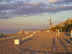
Torredembarra, normally called La Torre by its inhabitants, is a town in the comarca of the Tarragonès, in the province of Tarragona, Catalonia, Spain. It is located on the Costa Daurada, it faces Altafulla to the west, La Pobla de Montornès to the north, Creixell to the east and Mediterranean Sea in the south. It is 13 km to Tarragona's northeast and about 100 km southwest Barcelona.
The Coll de la Font de Cera is a mountain pass on the BP-5002 road across the Catalan Coastal Range from El Masnou to Granollers. The pass lies between the municipality of Alella, in the comarca of Maresme, and the municipality of Vallromanes, in the comarca of Vallès Oriental. Both municipalities are in the province of Barcelona, Catalonia, Spain.
The Coll de Can Bordoi is a mountain pass on the B-510 road across the Catalan Coastal Range from Dosrius to Llinars del Vallès. The pass lies in the municipality of Llinars del Vallès, comarca of Vallès Oriental, province of Barcelona, Catalonia, Spain.

Hortsavinyà is a village within the municipality of Tordera in the comarca of Maresme, province of Barcelona, Catalonia, Spain.

The Pont de l'Olivar is a bridge across the Sénia River in Spain. The northern side is in the municipality of Ulldecona, comarca of Montsià, province of Tarragona and autonomous community of Catalonia. The southern side is in the municipality of Vinaròs, comarca of Baix Maestrat, province of Castellón and autonomous community of Valencia. The bridge is included in the Inventory of the Architectural Heritage of Catalonia.