Calbiga, Samar

Last updated
Calbiga
Municipality of Calbiga
Etymology: Calviva
Ph locator samar calbiga.png
Map of Samar with Calbiga highlighted
Philippines location map (square).svg
Red pog.svg
Calbiga
Location within the Philippines
Coordinates: 11°38′N125°01′E / 11.63°N 125.02°E / 11.63; 125.02 Coordinates: 11°38′N125°01′E / 11.63°N 125.02°E / 11.63; 125.02
Country Flag of the Philippines.svg  Philippines
Region Eastern Visayas (Region VIII)
Province Samar
District 2nd district of Samar
Barangays 41 (see Barangays)
Government
[1]
  Type Sangguniang Bayan
   Mayor Melchor F. Nacario
   Vice Mayor Eva L. Castillo
  CongressmanSharee Ann T. Tan
  Electorate16,855 voters (2019)
Area
[2]
  Total283.70 km2 (109.54 sq mi)
Population
 (2015 census) [3]
  Total22,982
  Density81/km2 (210/sq mi)
Economy
   Income class 4th municipal income class
   Poverty incidence 37.43% (2015) [4]
  Revenue (₱)90,843,537.47 (2016)
Time zone UTC+8 (PST)
ZIP code
6715
PSGC
IDD : area code +63(0)55
Climate type tropical rainforest climate
Native languagesWaray
Tagalog
Website elgu.ncc.gov.ph/ecommunity/calbiga-wsamar/

Calbiga, officially the Municipality of Calbiga, is a 4th class municipality in the province of Samar, Philippines. According to the 2015 census, it has a population of 22,982 people. [3] The town is famous for the Langun-Gobingob Caves which is the largest cave system in the Philippines, reputed to be the second largest in Asia and the world's third largest karst formation. [5]

Contents

Geography

Barangays

Calbiga is politically subdivided into 41 barangays.

  • Antol
  • Bacyaran
  • Beri
  • Barobaybay
  • Binanggaran
  • Borong
  • Bulao
  • Buluan
  • Caamlongan
  • Calayaan
  • Calingonan
  • Canbagtic
  • Canticum
  • Daligan
  • Guimbanga
  • Hindang
  • Hubasan
  • Literon
  • Lubang
  • Mahangcao
  • Macaalan
  • Malabal
  • Minata
  • Otoc
  • Panayuran
  • Pasigay
  • Patong
  • Barangay 1 (Poblacion)
  • Barangay 2 (Poblacion)
  • Barangay 3 (Poblacion)
  • Barangay 4 (Poblacion)
  • Barangay 5 (Poblacion)
  • Barangay 6 (Poblacion)
  • Barangay 7 (Poblacion)
  • Polangi
  • Rawis
  • San Ignacio
  • San Mauricio
  • Sinalangtan
  • Timbangan
  • Tinago

Climate

Climate data for Calbiga, Samar
MonthJanFebMarAprMayJunJulAugSepOctNovDecYear
Average high °C (°F)27
(81)
28
(82)
28
(82)
30
(86)
30
(86)
30
(86)
29
(84)
29
(84)
29
(84)
29
(84)
28
(82)
28
(82)
29
(84)
Average low °C (°F)22
(72)
22
(72)
22
(72)
23
(73)
24
(75)
24
(75)
24
(75)
24
(75)
24
(75)
24
(75)
23
(73)
23
(73)
23
(74)
Average precipitation mm (inches)114
(4.5)
81
(3.2)
94
(3.7)
81
(3.2)
119
(4.7)
192
(7.6)
186
(7.3)
158
(6.2)
167
(6.6)
185
(7.3)
202
(8.0)
176
(6.9)
1,755
(69.2)
Average rainy days18.614.716.817.822.325.927.526.226.627.024.622.3270.3
Source: Meteoblue [6]

History

In 1649, Calbiga was an annex or visita of Catbalogan; later in 1768, Calbiga was transferred to the jurisdiction of Umauas. All through Jesuit times, Calbiga remained a visita until 1772, when it had its first residential pastor, the Franciscan Fray Miguel Rico (de Jesus), O.F.M.. Calbiga was constituted as a separate unit under the advocacy of the Anuncacion.

In 1803, Fray Juan Caballero de Brozas, O.F.M. built a wooden church but in 1808, a typhoon destroyed this church and was rebuilt by the same Fray Brozas. By 1840, Brozas's second church was in bad state.

In 1853, Fray Francisco Moreno de Montalbanejo. O.F.M. had gathered enough material for a stone church. However, Redondo (1884, 217) that the church was wood roofed with thatch.

The Jesuits left no permanent architectural imprint in the town.

The present barrio "Binongto-an (meaning, "once a town) was the original Calbiga settlement. Legend - as recorded by Atty. Singzon - has it that the people of Calbiga originated from two brothers, Calpis and Bituan. Bituan established a village near the mouth of the river while Calpis stayed upstream the exact location of the town today. The descendants of Bituan later abandoned the coastal village to join the descendants of Calpis.

Demographics

Population census of Calbiga
YearPop.±% p.a.
1903 5,399    
1918 10,153+4.30%
1939 14,071+1.57%
1948 15,591+1.15%
1960 12,868−1.59%
1970 16,364+2.43%
1975 14,697−2.13%
YearPop.±% p.a.
1980 14,201−0.68%
1990 17,116+1.88%
1995 18,070+1.02%
2000 18,890+0.96%
2007 20,309+1.00%
2010 21,434+1.98%
2015 22,982+1.34%
Source: Philippine Statistics Authority [3] [7] [8] [9]

Natural attractions

Langun-Gobingob Caves (Barangay Panayuran): The largest cave system in the Philippines, reputed to be the second largest in Asia and the world's third largest karst formation, is 7 km. long with an area of 900 square km. The area is composed of at least 12 interconnected caves. Locals believe that the caves are home to ancient primordial spirits and the spirits of Waray ancestors, making the caves one of the most sacred zones in Samar.

Lulugayan Falls and Rapids (Barangay Literon): Hundreds of waterfalls cascade down the 14-kilometer rapids from the source at Lake Kalidongan to the Calbiga River. The most majestic and panoramic is the Lulugayan Falls at Barangay Literon Correche. Approximately fifty meters wide, Lulugayan Falls has been dubbed by tourists as a Mini Niagara.

Kalidongan Lake (Barangay Literon): The eternal spring—the mythical crater-like lake, 90–100 meters in diameter, lined with clean white limestone. Its clear, fresh water endlessly flows down the rapids, onto the Calbiga River and Maqueda Bay.

Maqueda Bay and Mangrove Forests: The richest spawning grounds in Eastern Visayas for Fish and crustaceans and one of the pillars of the island's economy.

Calbiga River: The river is the town's thriving lifeline. Small bancas daily go upstream and loaded with native merchandise. It serves 17 barangays as transport byway and water source.

Kanyawa Caves (Barangay Caamlongan): A little farther to the east is another huge caves system recently explored by French and Italian spelunkers. The caves system consists of fifteen galleries of distinctive features and underground rivers, and numerous stalactites and stalagmites.

Children's Play Area and Nature Park (Barangay Bacyaran): The first phase of the Calbiga Nature Park will also include a Visitor's Center, Multi-purpose Pavilion, Amphitheater, Boardwalk and many more.

The Calbiga Fiesta

The Evangelization of Calbiga

When the Jesuits established missions in the island of Samar in 1696, Calbiga was served as a visita by the Jesuit resident mission in Umauas. In 1768, the Franciscans took over the administration of Samar and. Soon after, in 1771, Calbiga was established as a parish appointing Fray Miguel Rico (de Jesus), O.F.M. as the first cura paroco. For lack of missionaries. Umauas was joined to Calbiga until separated by a decree on March 12, 1863, giving Umauas its present name, Villa-Real.

The Original Patrona

Calbiga was then under the patronage of Nuestra Señora de los Angeles (Our Lady, Queen of the Angels) and the town’s special feast day was celebrated on August 2 even at the original settlement, Binongtoan, at the mouth of the Calbiga River. The transfer of the seacoast villagers to the upper part of the river, based on legend, was related to the miracles of the Virgin. Here’s a Portion of the report submitted to the Historical Commission by the Alcalde Mayor Perfecto Hacbang in 1938: “We also have a sample of unexplained happenings as follows: at the time when the town was still in the place of Binongto-an, the patron saint, then Nuestra Señora de los Angeles, would disappear from its site and was always found afterwards in the place where the town is located today. It was one of the main reasons why the people moved to this town.” This story was corroborated by historian-writer Atty. Filomeno Singzon in his article La Historia de la Virgen de la Anuncacion. The original wooden image of Nuestra Señora de los Angeles had a special niche beside the altar even after the antique church was demolished and replaced by concrete structure in the mid-Sixties, but during the finishing touches of its interiors, the “miraculous” image, together with some precious relics, the other santos, the silver candelabra, the other intricate wood carvings and the other “antiques” disappeared, never to be seen again.

From Nuestra Señora de los Angeles to Nuestra Señora de la Anuncacion

When Fray Juan Caballero de Brozas, O.F.M. built a strong wooden church in 1803, he dedicated it to Nuestra Senora de la Anuncacion (Our Lady of the Annunciation) whose feast day falls on March 25. But the Calbiganons continued to venerate the image of Nuestra Señora de los Angeles until it was replaced by a new image of a kneeling virgin with the Archangel Gabriel, during the hermanidad of Señora Mamerta Quimbo Abellar de Singzon sometime after the church was built and dedicated to Nuestra Señora de la Anuncacion in 1803.

Schools

Related Research Articles

Abuyog, Leyte Municipality in Eastern Visayas, Philippines

Abuyog, officially the Municipality of Abuyog, is a 1st class municipality in the province of Leyte, Philippines. According to the 2015 census, it has a population of 59,571 people.

Hernani, Eastern Samar Municipality in Eastern Visayas, Philippines

Hernani, officially the Municipality of Hernani, is a 5th class municipality in the province of Eastern Samar, Philippines. According to the 2015 census, it has a population of 8,573 people.

San Julian, Eastern Samar Municipality in Eastern Visayas, Philippines

San Julian, officially the Municipality of San Julian, is a 5th class municipality in the province of Eastern Samar, Philippines. According to the 2015 census, it has a population of 14,498 people.

Catarman, Northern Samar Municipality in Eastern Visayas, Philippines

Catarman, officially the Municipality of Catarman,, is a 1st class municipality and capital of the province of Northern Samar, Philippines. According to the 2015 census, it has a population of 94,037 people.

Barugo, Leyte Municipality in Eastern Visayas, Philippines

Barugo, officially the Municipality of Barugo, is a 4th class municipality in the province of Leyte, Philippines. According to the 2015 census, it has a population of 32,745 people.

Almagro, Samar Municipality in Eastern Visayas, Philippines

Almagro, officially the Municipality of Almagro, is a 5th class municipality in the province of Samar, Philippines. According to the 2015 census, it has a population of 8,942 people.

Pagsanghan, Samar Municipality in Eastern Visayas, Philippines

Pagsanghan, officially the Municipality of Pagsanghan, is a 5th class municipality in the province of Samar, Philippines. According to the 2015 census, it has a population of 7,945 people.

San Jose de Buan, Samar Municipality in Eastern Visayas, Philippines

San Jose de Buan, officially the Municipality of San Jose de Buan, is a 4th class municipality in the province of Samar, Philippines. According to the 2015 census, it has a population of 7,769 people.

San Sebastian, Samar Municipality in Eastern Visayas, Philippines

San Sebastian, officially the Municipality of San Sebastian, is a 6th class municipality in the province of Samar, Philippines. According to the 2015 census, it has a population of 8,057 people.

Talalora, Samar Municipality in Eastern Visayas, Philippines

Talalora, officially the Municipality of Talalora, is a 6th class municipality in the province of Samar, Philippines. According to the 2015 census, it has a population of 8,057 people.

Tarangnan, Samar Municipality in Eastern Visayas, Philippines

Tarangnan, officially the Municipality of Tarangnan, is a 4th class municipality in the province of Samar, Philippines. According to the 2015 census, it has a population of 24,992 people.

Capul Municipality in Eastern Visayas, Philippines

Capul, officially the Municipality of Capul, is a 5th class municipality in the province of Northern Samar, Philippines. According to the 2015 census, it has a population of 12,679 people.

Catubig, Northern Samar Municipality in Eastern Visayas, Philippines

Catubig, officially the Municipality of Catubig, is a 3rd class municipality in the province of Northern Samar, Philippines. According to the 2015 census, it has a population of 33,025 people.

Laoang, Northern Samar Municipality in Eastern Visayas, Philippines

Laoang, officially the Municipality of Laoang, is a 2nd class municipality in the province of Northern Samar, Philippines. According to the 2015 census, it has a population of 61,359 people.

Borongan Component City in Eastern Visayas, Philippines

Borongan, officially the City of Borongan,, or simply referred to as Borongan City, is a 4th class city and capital of the province of Eastern Samar, Philippines. According to the 2015 census, it has a population of 69,297 people.

Can-avid Municipality in Eastern Visayas, Philippines

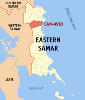
Can-avid,, officially the Municipality of Can-avid, is a 4th class municipality in the province of Eastern Samar, Philippines. According to the 2015 census, it has a population of 21,015 people.

General MacArthur, Eastern Samar Municipality in Eastern Visayas, Philippines

General MacArthur, officially the Municipality of General MacArthur, is a 5th class municipality in the province of Eastern Samar, Philippines. According to the 2015 census, it has a population of 14,550 people.

Guiuan Municipality in Eastern Visayas, Philippines

Guiuan, officially the Municipality of Guiuan, is a 2nd class municipality in the province of Eastern Samar, Philippines. According to the 2015 census, it has a population of 52,991 people.

Taft, Eastern Samar Municipality in Eastern Visayas, Philippines

Taft, officially the Municipality of Taft, is a 4th class municipality in the province of Eastern Samar, Philippines. According to the 2015 census, it has a population of 18,915 people.

Catbalogan Component City in Eastern Visayas, Philippines

Catbalogan, officially the City of Catbalogan, or simply referred to as Catbalogan City, is the capital of Samar, Philippines. According to the 2015 census, it has a population of 103,879 people.

References

  1. "Municipality". Quezon City, Philippines: Department of the Interior and Local Government. Retrieved 31 May 2013.
  2. "Province: Samar (Western Samar)". PSGC Interactive. Quezon City, Philippines: Philippine Statistics Authority . Retrieved 12 November 2016.
  3. 1 2 3 Census of Population (2015). "Region VIII (Eastern Visayas)". Total Population by Province, City, Municipality and Barangay. PSA . Retrieved 20 June 2016.
  4. "PSA releases the 2015 Municipal and City Level Poverty Estimates". Quezon City, Philippines. Retrieved 12 October 2019.
  5. https://www.traveling-up.com/exploring-the-underworld-calbiga-caves-samar/
  6. "Calbiga: Average Temperatures and Rainfall". Meteoblue. Retrieved 29 February 2020.
  7. Census of Population and Housing (2010). "Region VIII (Eastern Visayas)". Total Population by Province, City, Municipality and Barangay. NSO . Retrieved 29 June 2016.
  8. Censuses of Population (1903–2007). "Region VIII (Eastern Visayas)". Table 1. Population Enumerated in Various Censuses by Province/Highly Urbanized City: 1903 to 2007. NSO.
  9. "Province of Samar (Western Samar)". Municipality Population Data. Local Water Utilities Administration Research Division. Retrieved 17 December 2016.