Paranas, Samar

Last updated
Paranas

Wright
Municipality of Paranas
Ph locator samar paranas.png
Map of Samar with Paranas highlighted
OpenStreetMap
Paranas, Samar
Philippines location map (square).svg
Red pog.svg
Paranas
Location within the Philippines
Coordinates: 11°51′N125°07′E / 11.85°N 125.12°E / 11.85; 125.12 Coordinates: 11°51′N125°07′E / 11.85°N 125.12°E / 11.85; 125.12
Country Flag of the Philippines.svg  Philippines
Region Eastern Visayas (Region VIII)
Province Samar
District 2nd district of Samar
Barangays 44 (see Barangays)
Government
[1]
  Type Sangguniang Bayan
   Mayor Eunice Uy-Babalcon
   Vice Mayor Yolanda T. Tan
   Congressman Sharee Ann T. Tan
   Municipal Council
  Electorate22,259 voters (2019)
Area
[2]
  Total556.12 km2 (214.72 sq mi)
Population
 (2015 census) [3]
  Total30,557
  Density55/km2 (140/sq mi)
  Households
6,294
Economy
   Income class 2nd municipal income class
   Poverty incidence 39.2% (2015) [4]
  Revenue (₱)135,882,415.48 (2016)
Time zone UTC+8 (PST)
ZIP code
6716
PSGC
IDD : area code +63(0)55
Climate type tropical rainforest climate
Native languagesWaray
Tagalog

Paranas, officially the Municipality of Paranas (Waray : Bungto han Paranas; Tagalog : Bayan ng Paranas), is a 2nd class municipality in the province of Samar, Philippines. According to the 2015 census, it has a population of 30,557 people. [3]

Contents

It was formerly known as Wright named after American Governor General Luke E. Wright.

Many of the townsfolk work or attend school in nearby Catbalogan City. Trade is also prevalent with Calbayog City farther north.

A part of Paranas is devoted to a nature reserve watershed designated as such by the Department of Environment and Natural Resources.

Barangays

Paranas is politically subdivided into 44 barangays.

Climate

Climate data for Paranas, Samar
MonthJanFebMarAprMayJunJulAugSepOctNovDecYear
Average high °C (°F)27
(81)
28
(82)
28
(82)
30
(86)
30
(86)
30
(86)
29
(84)
29
(84)
29
(84)
29
(84)
28
(82)
28
(82)
29
(84)
Average low °C (°F)22
(72)
22
(72)
22
(72)
23
(73)
24
(75)
24
(75)
24
(75)
24
(75)
24
(75)
24
(75)
23
(73)
23
(73)
23
(74)
Average precipitation mm (inches)114
(4.5)
81
(3.2)
94
(3.7)
81
(3.2)
119
(4.7)
192
(7.6)
186
(7.3)
158
(6.2)
167
(6.6)
185
(7.3)
202
(8.0)
176
(6.9)
1,755
(69.2)
Average rainy days18.614.716.817.822.325.927.526.226.627.024.622.3270.3
Source: Meteoblue [5]

History

A strip of sand bordering along the coast of the Maqueda Bay, nestling at the foot of a hill which shields it from floods and storms was inhibited by a few natives who engaged in fishing and farming. As time went on, the number of people increased. More and better houses were built and a village was farming. So it attracted many people to trade with the natives and to dwell in it.

The trees along the line of sand were cut down and a street was laid. The increasing inhabitants built nipa houses on both side of the street. As the village expanded the people opened other streets toward the hill.

Shortly after the occupation of the Spaniards in Catbalogan some of them went to Wright, the newly made village. When they reached the village, the tide was low and many of the natives were along the stony coast picking and gathering shellfish and crabs. The banca headed toward the place where the people settled. One of the Spanish Officials asked for the name of the place or the village in Spanish language. The ignorant native looked boastfully at the over tall stranger. Thinking that the Spaniard was asking for the name of slippery rock which the Spaniard was apparently looking at, the native answered “Palanas”, name of the rock. The Spaniard then pronounced the word “Paranas” instead of palanas and recorded it as the name of the village. They went ashore and organized the village government and appointed its officials under the banner of Spain.

The Spanish sovereignty over the village had greatly inspired the natives. The doctrine of Christianity was introduced and the people willingly and readily accepted and believe it. Through the course of time, the village grew to the end and be one of the progressive towns along the shore of the Maqueda Bay. A Catholic church and a convent were erected and a thick high wall around the church site was constructed.

When America succeeded in overthrowing Spain during the Spanish–American War, the Philippines was ceded to her. Paranas was at the height of her glory at that time. In 1890 during the Philippine–American War the Paranasnon were one of these who showed strong resistance against the American Forces. American troops headed by General Curry came sudden and subdue the Revolutionist here in Paranas. Most of the native fled to the mountain. The revolutionist fought hard and bravely. Many American lives were lost here. In one of these encounters General Curry was lost I the midst of the forest where they were the old people of Paranas or Wright.

General Curry had been in the wilderness for three days and the man who saved him was taken to the United States with him. Due to the hospitality and kindness of the people of Paranas one of General Curry’s savior. General Curry recommended the changed of the name of the town Paranas to Wright in honor of the governor General of the Philippines at that time. Because of its location the town of Wright engage in two main industries:

  1. 1. Farming
  2. 2. Fishing

They engage in farming because on the eastern part of the areas to town are wide vast of land on the western part in a fertile ground for fishing. The wide of land are converted into rice fields both for upland and lowland rice. One unique kind of rice that is so anosmatic and palatable to the town to town to eat is the famous “Kalinayan” an upload rice that is favorable to most of the town folks. Aside from rice, fruits, vegetables; root cops are so cheap and abundant that people of Wright used to sell to other places. The biggest and surest market of these products are the capital town of Catbalogan and Bagacay, the set of the copper mine is Samar

From the Maqueda bay, fish fresh of different kinds are so plentiful that people who engaged in fishing earned enough for the family support. Aside from the fish sea shells can also be gathered from there. The famous bahong, sabuad, baliad, ponao, saringa, bocawil, and others so plentiful and more than enough for the town’s consumption.

The people of Wright are lovers of socials and they love dance the Curracha. The Summer time Club is a town organization composed of both the married and single group that usually hold its annual affair very beginning of the summer vacation.

During the American period, Paranas was renamed by the new administrators to Wright, in honour of General Wright. However, locals retained and still use the name Paranas. It absorbed the former town of San Sebastian. In 1950, the barrios of San Sebastian, Jitaasan, Dolores, Camanjagay, Bontod, Campidasa, Campiyak, Maslog, Balogo, Maropangpang, Binongtoan, and Bolwan was re-created as a town. [6]

In 1955 the sitio of Madalanot was converted into a barrio. [7]

The First Settlers of the Town of Paranas

Past Municipal Mayors of the Town of Paranas

Bruna Fabrigar

Bruna Fabrigar - (locally knowns as Bunang) is a local hero in Paranas, Samar and one of brave and courageous leaders of the famous Pulajanes Movement during the Philippine–American War.

Demographics

Population census of Paranas
YearPop.±% p.a.
1918 12,847    
1939 17,716+1.54%
1948 16,717−0.64%
1960 16,267−0.23%
1970 17,352+0.65%
1975 19,386+2.25%
1980 21,556, 22,702    
1990 22,702, 22,702    
1995 24,235    
2000 27,926+3.09%
2007 27,820−0.05%
2010 29,327+1.94%
2015 30,557+0.79%
Source: Philippine Statistics Authority [3] [8] [9] [10]

Transportation

The Pan-Philippine Highway traverses Paranas.

Domestic air travelers prefer to return to Paranas via dominant Tacloban's Daniel Z. Romualdez Airport due to the length of the runway and the accessibility of land transportation. Other options include the improved Calbayog Airport and the less utilized Catbalogan Airport (which is only ideal for smaller aircraft). International air travelers may also reach Paranas via Manila, Cebu or Davao en route to Tacloban. In the next few months, Tacloban's airport is being readied for direct international flights.

Local Beliefs

Townspeople living off the coast of Paranas believe turtles that come to die ashore are omens of danger, harbingers of typhoons and ocean-related accidents. The old fisherfolk dare not touch nor disturb these docile creatures because of this superstition. Green sea turtles and Loggerhead turtles frequent some coves off Samar to lay eggs or wade near the shallow areas to explore. Gigantic Loggerhead turtles are especially rare visitors even in the yesteryears. When they come ashore and do not lay eggs, tears flow from their eyes like humans. They would then die as the blazing sun rises and their bodies are scorched. Afterwards, fishermen go missing at sea, typhoons arrive, bancas capsize or cargo ships sink. Residents attest turtles came to die on their shores when M/V Dona Paz sank causing thousands of people to drown to their deaths.

Related Research Articles

Samar (province) Province in Eastern Visayas, Philippines

Samar, formerly named as Western Samar, is a province in the Philippines located in the Eastern Visayas region. Its capital is the city of Catbalogan. It is bordered by Northern Samar, Eastern Samar, Leyte and the Leyte Gulf, and includes several islands in the Samar Sea. Samar is connected to the island of Leyte via the San Juanico Bridge.

Balangiga, Eastern Samar Municipality in Eastern Visayas, Philippines

Balangiga, officially the Municipality of Balangiga, is a 4th class municipality in the province of Eastern Samar, Philippines. According to the 2015 census, it has a population of 14,085 people.

Babatngon Municipality in Eastern Visayas, Philippines

Babatngon, officially the Municipality of Babatngon, is a 4th class municipality in the province of Leyte, Philippines. According to the 2015 census, it has a population of 27,797 people.

Catarman, Northern Samar Municipality in Eastern Visayas, Philippines

Catarman, officially the Municipality of Catarman,, is a 1st class municipality and capital of the province of Northern Samar, Philippines. According to the 2015 census, it has a population of 94,037 people.

Calasiao Municipality in Ilocos Region, Philippines

Calasiao, officially the Municipality of Calasiao, is a 1st class municipality in the province of Pangasinan, Philippines. According to the 2015 census, it has a population of 95,154 people.

Barugo Municipality in Eastern Visayas, Philippines

Barugo, officially the Municipality of Barugo, is a 4th class municipality in the province of Leyte, Philippines. According to the 2015 census, it has a population of 32,745 people.

Calbiga Municipality in Eastern Visayas, Philippines

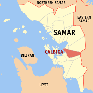
Calbiga, officially the Municipality of Calbiga, is a 4th class municipality in the province of Samar, Philippines. According to the 2015 census, it has a population of 22,982 people. The town is famous for the Langun-Gobingob Caves which is the largest cave system in the Philippines, reputed to be the second largest in Asia and the world's third largest karst formation.

Daram, Samar Municipality in Eastern Visayas, Philippines

Daram, officially the Municipality of Daram, is a 3rd class municipality in the province of Samar, Philippines. According to the 2015 census, it has a population of 42,879 people.

Jiabong Municipality in Eastern Visayas, Philippines

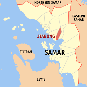
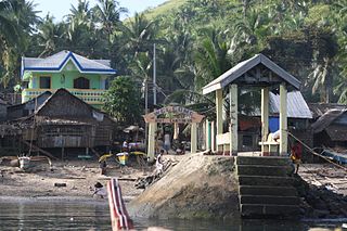
Jiabong, officially the Municipality of Jiabong, is a 5th class municipality in the province of Samar, Philippines. According to the 2015 census, it has a population of 18,342 people.

San Sebastian, Samar Municipality in Eastern Visayas, Philippines

San Sebastian, officially the Municipality of San Sebastian, is a 6th class municipality in the province of Samar, Philippines. According to the 2015 census, it has a population of 8,057 people.

Tarangnan Municipality in Eastern Visayas, Philippines

Tarangnan, officially the Municipality of Tarangnan, is a 4th class municipality in the province of Samar, Philippines. According to the 2015 census, it has a population of 24,992 people.

Zumarraga, Samar Municipality in Eastern Visayas, Philippines

Zumarraga, officially the Municipality of Zumarraga, is a 5th class island municipality in the province of Samar, Philippines. According to the 2015 census, it has a population of 16,295 people.

Allen, Northern Samar Municipality in Eastern Visayas, Philippines

Allen, officially the Municipality of Allen, is a 5th class municipality in the province of Northern Samar, Philippines. According to the 2015 census, it has a population of 25,469 people.

Lope de Vega, Northern Samar Municipality in Eastern Visayas, Philippines

Lope de Vega, officially the Municipality of Lope de Vega, is a 4th class municipality in the province of Northern Samar, Philippines. According to the 2015 census, it has a population of 14,687 people.

Palapag Municipality in Eastern Visayas, Philippines

Palapag, officially the Municipality of Palapag, is a 3rd class municipality in the province of Northern Samar, Philippines. According to the 2015 census, it has a population of 34,286 people.

Caramoan Municipality in Bicol Region, Philippines

Caramoan, officially the Municipality of Caramoan, is a 2nd class municipality in the province of Camarines Sur, Philippines. According to the 2015 census, it has a population of 47,605 people.

Borongan Component city in Eastern Visayas, Philippines

Borongan, officially the City of Borongan, is a 4th class city and capital of the province of Eastern Samar, Philippines. According to the 2015 census, it has a population of 69,297 people.

Pastrana, Leyte Municipality in Eastern Visayas, Philippines

Pastrana, officially the Municipality of Pastrana, is a 5th class municipality in the province of Leyte, Philippines. According to the 2015 census, it has a population of 18,002 people.

Catbalogan Component city in Eastern Visayas, Philippines

Catbalogan, officially the City of Catbalogan, is the capital of the province of Samar, Philippines. According to the 2015 census, it has a population of 103,879 people.

Eastern Visayas Administrative region of the Philippines

Eastern Visayas is an administrative region in the Philippines, designated as Region VIII. It consists of three main islands, Samar, Leyte and Biliran. The region has six provinces, one independent city and one highly urbanized city namely, Biliran, Leyte, Northern Samar, Samar, Eastern Samar, Southern Leyte, Ormoc and Tacloban. The highly urbanized city of Tacloban is the sole regional center. These provinces and cities occupy the easternmost islands of the Visayas group of islands.

References

  1. "Municipality". Quezon City, Philippines: Department of the Interior and Local Government. Retrieved 31 May 2013.
  2. "Province: Samar (Western Samar)". PSGC Interactive. Quezon City, Philippines: Philippine Statistics Authority . Retrieved 12 November 2016.
  3. 1 2 3 Census of Population (2015). "Region VIII (Eastern Visayas)". Total Population by Province, City, Municipality and Barangay. PSA . Retrieved 20 June 2016.
  4. "PSA releases the 2015 Municipal and City Level Poverty Estimates". Quezon City, Philippines. Retrieved 12 October 2019.
  5. "Paranas: Average Temperatures and Rainfall". Meteoblue. Retrieved 29 February 2020.
  6. "An act re-creating the municipality of San Sebastian, province of Samar". LawPH.com. Retrieved 2011-04-09.
  7. "An Act Creating the Barrio of Madalanot, in the Municipality of Wright, Province of Samar". LawPH.com. Retrieved 2011-04-11.
  8. Census of Population and Housing (2010). "Region VIII (Eastern Visayas)". Total Population by Province, City, Municipality and Barangay. NSO . Retrieved 29 June 2016.
  9. Censuses of Population (1903–2007). "Region VIII (Eastern Visayas)". Table 1. Population Enumerated in Various Censuses by Province/Highly Urbanized City: 1903 to 2007. NSO.
  10. "Province of Samar (Western Samar)". Municipality Population Data. Local Water Utilities Administration Research Division. Retrieved 17 December 2016.